![](/images/other/stat-length.png)
![Randonnée Marche Caves - Caves (11), le sentier de la Garrigue - Photo](https://media.geolcdn.com/t/1900/400/ext.pjpeg?maxdim=2&url=https%3A%2F%2Fstatic1.geolcdn.com%2Fsiteimages%2Fupload%2Ffiles%2F1553511878bg_sport_marche.png)
Caves (11), le sentier de la Garrigue
Santblasi
Utilisateur
![Longueur](/images/other/stat-length.png)
Longueur
9 km
![Altitude max](https://static1.geolcdn.com/siteimages/upload/files/1508320355ic_sort_altitude_max_24dp.png)
Altitude max
202 m
![Dénivelé positif](https://static1.geolcdn.com/siteimages/upload/files/1508320355ic_sort_den_pos_24dp.png)
Dénivelé positif
187 m
![Km-Effort](/images/other/stat-length.png)
Km-Effort
11,5 km
![Altitude min](https://static1.geolcdn.com/siteimages/upload/files/1508320355ic_sort_altitude_min_24dp.png)
Altitude min
30 m
![Dénivelé négatif](https://static1.geolcdn.com/siteimages/upload/files/1508320355ic_sort_den_neg_24dp.png)
Dénivelé négatif
167 m
![Boucle](https://static1.geolcdn.com/siteimages/upload/files/16400158638029165_repeat_loop_refresh_sync_direction_icon.png)
Boucle
Non
Date de création :
2024-09-24 07:08:55.489
Dernière modification :
2024-09-24 16:05:42.705
![Marche](https://static1.geolcdn.com/sitytour/trail-icons/101.png)
3h30
Difficulté : Moyen
![Scannez ce code QR pour ouvrir la randonnée dans l'application SityTrail](https://capi.geolives.com/qq0zvz2zws4bq2lad0pu/sitytour/trails/4200719/qr.png?size=200)
Application GPS de randonnée GRATUITE
À propos
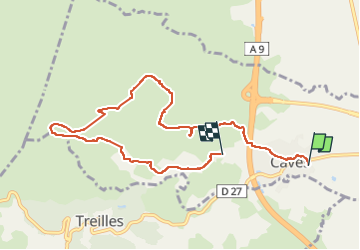
Randonnée Marche de 9 km à découvrir à Occitanie, Aude, Caves. Cette randonnée est proposée par Santblasi.
Description
Départ parking de la mairie.
Très bon marquage (panneaux directionnels et peinture).
De nombreux points de vue mer et côteaux, garrigue, combes. Routes, pistes carrossables et sentiers, nombreux passages ombragés.
Localisation
Pays :
France
Région :
Occitanie
Département/Province :
Aude
Commune :
Caves
Localité :
Unknown
Départ:(Dec)
Départ:(UTM)
498307 ; 4753123 (31T) N.
Commentaires
Randonnées à proximité
![Randonnée Marche Leucate - mon sentier des pêcheurs - Photo](https://media.geolcdn.com/t/375/260/d041d0df-07da-4421-a9ea-d982392d3e0c.jpg&format=jpg&maxdim=2)
![Marche Marche](https://static1.geolcdn.com/sitytour/trail-icons/101.png)
mon sentier des pêcheurs
Marche
Très facile
(1)
Leucate,
Occitanie,
Aude,
France
![](/images/other/stat-length.png)
5,6 km | 6,5 km-effort
2h 7min
![](https://static1.geolcdn.com/siteimages/upload/files/16400158638029165_repeat_loop_refresh_sync_direction_icon.png)
Oui
![Randonnée Marche Leucate - Leucate village - Photo](https://media.geolcdn.com/t/375/260/ext.jpg?maxdim=2&url=https%3A%2F%2Fservices.sitytrail.com%2FGeolivesWS%2FDownloadMedia.ashx%3FTrailID%3D179085%26Media%3Df1524f36-0682-4bf6-975a-882cd23421f5.JPG)
![Marche Marche](https://static1.geolcdn.com/sitytour/trail-icons/101.png)
![Randonnée V.T.T. Leucate - Leucate sur un plateau ! - Photo](https://media.geolcdn.com/t/375/260/ext.jpg?maxdim=2&url=https%3A%2F%2Fservices.sitytrail.com%2FGeolivesWS%2FDownloadMedia.ashx%3FTrailID%3D100672%26Media%3D196_3.jpg)
![V.T.T. V.T.T.](https://static1.geolcdn.com/sitytour/trail-icons/202.png)
Leucate sur un plateau !
V.T.T.
Facile
(1)
Leucate,
Occitanie,
Aude,
France
![](/images/other/stat-length.png)
10,8 km | 12,4 km-effort
45min
![](https://static1.geolcdn.com/siteimages/upload/files/16400158638029165_repeat_loop_refresh_sync_direction_icon.png)
Non
![Randonnée Marche La Palme - La palme 17_09_2020 - Photo](https://media.geolcdn.com/t/375/260/d7f347aa-f418-4dc5-9ccc-da38c1b77565.jpg&format=jpg&maxdim=2)
![Marche Marche](https://static1.geolcdn.com/sitytour/trail-icons/101.png)
La palme 17_09_2020
Marche
Très facile
(2)
La Palme,
Occitanie,
Aude,
France
![](/images/other/stat-length.png)
7,5 km | 8,9 km-effort
1h 51min
![](https://static1.geolcdn.com/siteimages/upload/files/16400158638029165_repeat_loop_refresh_sync_direction_icon.png)
Oui
![Randonnée V.T.T. Leucate - VTT Leucate La Palme - Photo](https://media.geolcdn.com/t/375/260/f6afc4d0-f8dc-4d8d-bdc2-3236cac7bfec.jpg&format=jpg&maxdim=2)
![V.T.T. V.T.T.](https://static1.geolcdn.com/sitytour/trail-icons/202.png)
VTT Leucate La Palme
V.T.T.
Facile
(1)
Leucate,
Occitanie,
Aude,
France
![](/images/other/stat-length.png)
29 km | 32 km-effort
2h 10min
![](https://static1.geolcdn.com/siteimages/upload/files/16400158638029165_repeat_loop_refresh_sync_direction_icon.png)
Oui
![Randonnée Marche Leucate - plateau leucate - sud est - Photo](https://media.geolcdn.com/t/375/260/fc551c80-a7a1-459f-83d9-ef8bc94cafd9.jpg&format=jpg&maxdim=2)
![Marche Marche](https://static1.geolcdn.com/sitytour/trail-icons/101.png)
plateau leucate - sud est
Marche
Facile
Leucate,
Occitanie,
Aude,
France
![](/images/other/stat-length.png)
11,1 km | 13 km-effort
3h 23min
![](https://static1.geolcdn.com/siteimages/upload/files/16400158638029165_repeat_loop_refresh_sync_direction_icon.png)
Oui
![Randonnée Marche Leucate - leucate - cap des frères (sentier des bergers) -la franqui (sentier des guetteurs) - leucate (se tier des vignerons) - Photo](https://media.geolcdn.com/t/375/260/5389bc4c-6ebc-475a-8eed-23be4124a740.jpg&format=jpg&maxdim=2)
![Marche Marche](https://static1.geolcdn.com/sitytour/trail-icons/101.png)
leucate - cap des frères (sentier des bergers) -la franqui (sentier des guett...
Marche
Difficile
Leucate,
Occitanie,
Aude,
France
![](/images/other/stat-length.png)
10,6 km | 12,5 km-effort
4h 22min
![](https://static1.geolcdn.com/siteimages/upload/files/16400158638029165_repeat_loop_refresh_sync_direction_icon.png)
Oui
![Randonnée Marche Leucate - Leucate-plateau- A/sentier du vigneronx et R/ sentier du berger - Photo](https://media.geolcdn.com/t/375/260/ext.jpg?maxdim=2&url=https%3A%2F%2Fstatic1.geolcdn.com%2Fsiteimages%2Fupload%2Ffiles%2F1553511878bg_sport_marche.png)
![Marche Marche](https://static1.geolcdn.com/sitytour/trail-icons/101.png)
Leucate-plateau- A/sentier du vigneronx et R/ sentier du berger
Marche
Facile
(1)
Leucate,
Occitanie,
Aude,
France
![](/images/other/stat-length.png)
10,1 km | 12,3 km-effort
2h 47min
![](https://static1.geolcdn.com/siteimages/upload/files/16400158638029165_repeat_loop_refresh_sync_direction_icon.png)
Oui
![Randonnée Marche Leucate - Leucate château falaise - Photo](https://media.geolcdn.com/t/375/260/3cce4778-81ed-4254-af5e-b0b5f1ccbabf.jpg&format=jpg&maxdim=2)
![Marche Marche](https://static1.geolcdn.com/sitytour/trail-icons/101.png)
Leucate château falaise
Marche
Très facile
Leucate,
Occitanie,
Aude,
France
![](/images/other/stat-length.png)
15,2 km | 17,8 km-effort
3h 31min
![](https://static1.geolcdn.com/siteimages/upload/files/16400158638029165_repeat_loop_refresh_sync_direction_icon.png)
Oui