![](/images/other/stat-length.png)
![Randonnée Marche Buno-Bonnevaux - Buno-Bonneveaux - Polissoir de Grimery - Photo](https://media.geolcdn.com/t/1900/400/fb45abfa-aec4-48f6-b6e7-2e3f4580f3ae.jpg&format=pjpeg&maxdim=2)
Buno-Bonneveaux - Polissoir de Grimery
guydu41
Utilisateur
![Longueur](/images/other/stat-length.png)
![Altitude max](https://static1.geolcdn.com/siteimages/upload/files/1508320355ic_sort_altitude_max_24dp.png)
![Dénivelé positif](https://static1.geolcdn.com/siteimages/upload/files/1508320355ic_sort_den_pos_24dp.png)
![Km-Effort](/images/other/stat-length.png)
![Altitude min](https://static1.geolcdn.com/siteimages/upload/files/1508320355ic_sort_altitude_min_24dp.png)
![Dénivelé négatif](https://static1.geolcdn.com/siteimages/upload/files/1508320355ic_sort_den_neg_24dp.png)
![Boucle](https://static1.geolcdn.com/siteimages/upload/files/16400158638029165_repeat_loop_refresh_sync_direction_icon.png)
![Marche](https://static1.geolcdn.com/sitytour/trail-icons/101.png)
2h00
Difficulté : Moyen
![Scannez ce code QR pour ouvrir la randonnée dans l'application SityTrail](https://capi.geolives.com/qq0zvz2zws4bq2lad0pu/sitytour/trails/4195465/qr.png?size=200)
Application GPS de randonnée GRATUITE
À propos
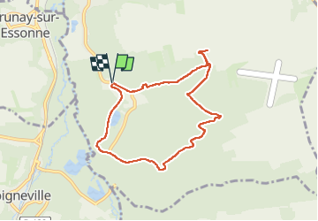
Randonnée Marche de 7,5 km à découvrir à Île-de-France, Essonne, Buno-Bonnevaux. Cette randonnée est proposée par guydu41.
Description
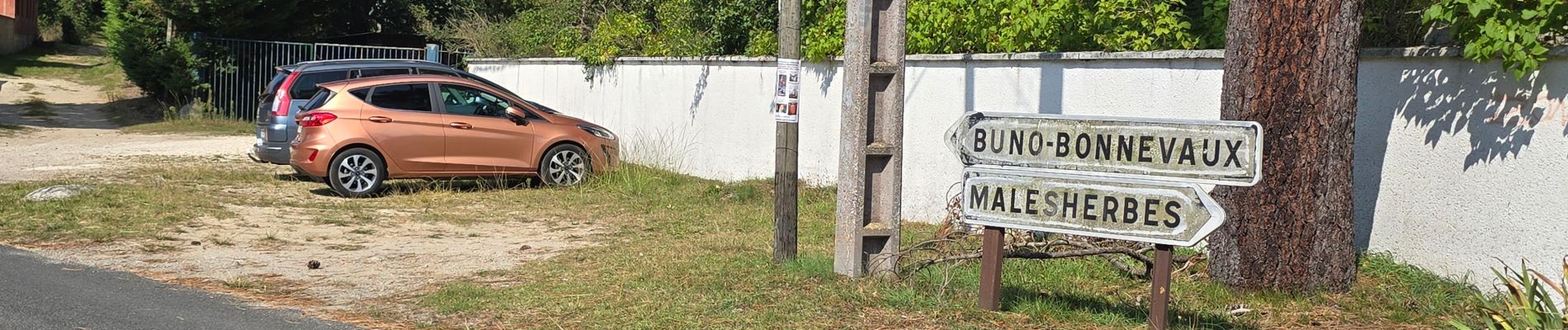
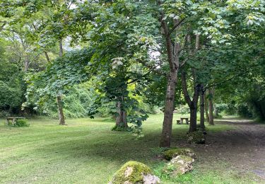
Le circuit en sens horaire commence depuis un petit parking au Hameau de Chantambre, 8 Route de Malesherbes, 91720 Buno-Bonnevaux.
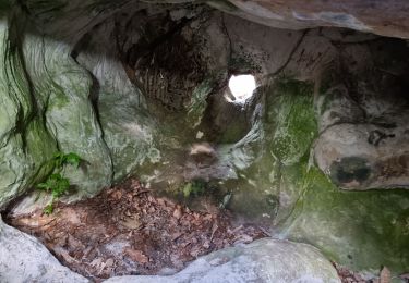
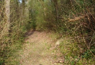
Dans la vallée boisée de Vautretion il chemine sur des sentiers étroits, tortueux, embroussaillés, longeant plusieurs chaos rocheux pour remonter sur le haut du côteau.
L’approche du mégalithe se fait par un chemin puis un sentier envahi par les ronces pour arriver en bordure d’un champ (sécateur fortement recommandé).
Sur le haut du plateau, il faut longer un champ ceinturé par une petite clôture électrique jusqu’au Polissoir de Grimery situé à la lisière du bois.
Remarque importante : Respectez la clôture, les surfaces cultivées et ne marchez pas dans le champ.
Reprendre le même chemin pour redescendre dans la vallée puis le quitter en empruntant des chemins larges et entretenus descendant vers la Grande Vallée puis vers la vallée de l'Essonne jusqu'à Chantambre.
Localisation
Commentaires
Randonnées à proximité
![Randonnée Marche Buno-Bonnevaux - Buno-Bonnevaux - Photo](https://media.geolcdn.com/t/375/260/e394442e-ae33-4b53-86f2-60fa2b279771.jpg&format=jpg&maxdim=2)
![Marche Marche](https://static1.geolcdn.com/sitytour/trail-icons/101.png)
Marche
![](/images/other/stat-length.png)
![](https://static1.geolcdn.com/siteimages/upload/files/16400158638029165_repeat_loop_refresh_sync_direction_icon.png)
![Randonnée Marche Maisse - De Maisse à La Fertè Alais via Boutigny - Photo](https://media.geolcdn.com/t/375/260/ext.jpg?maxdim=2&url=https%3A%2F%2Fstatic1.geolcdn.com%2Fsiteimages%2Fupload%2Ffiles%2F1553511878bg_sport_marche.png)
![Marche Marche](https://static1.geolcdn.com/sitytour/trail-icons/101.png)
Marche
![](/images/other/stat-length.png)
![](https://static1.geolcdn.com/siteimages/upload/files/16400158638029165_repeat_loop_refresh_sync_direction_icon.png)
![Randonnée Marche Buno-Bonnevaux - Buneau-Bonnevaux Menhir de la pierre droite - Photo](https://media.geolcdn.com/t/375/260/2f306896-f313-4a5f-a380-c29ec6b616bc.jpg&format=jpg&maxdim=2)
![Marche Marche](https://static1.geolcdn.com/sitytour/trail-icons/101.png)
Marche
![](/images/other/stat-length.png)
![](https://static1.geolcdn.com/siteimages/upload/files/16400158638029165_repeat_loop_refresh_sync_direction_icon.png)
![Randonnée sport Buno-Bonnevaux - Sob 2 buno briarres - Photo](https://media.geolcdn.com/t/375/260/a7cbaf0f-1a82-49bb-af31-e1517606af56.jpg&format=jpg&maxdim=2)
sport
![](/images/other/stat-length.png)
![](https://static1.geolcdn.com/siteimages/upload/files/16400158638029165_repeat_loop_refresh_sync_direction_icon.png)
![Randonnée Marche Buno-Bonnevaux - buno bonneveau - Photo](https://media.geolcdn.com/t/375/260/ext.jpg?maxdim=2&url=https%3A%2F%2Fservices.sitytrail.com%2FGeolivesWS%2FDownloadMedia.ashx%3FTrailID%3D262814%26Media%3Dfix__20140402184301.jpg)
![Marche Marche](https://static1.geolcdn.com/sitytour/trail-icons/101.png)
Marche
![](/images/other/stat-length.png)
![](https://static1.geolcdn.com/siteimages/upload/files/16400158638029165_repeat_loop_refresh_sync_direction_icon.png)
![Randonnée Marche Buno-Bonnevaux - Buno Bonnevaux 2024 - Photo](https://media.geolcdn.com/t/375/260/ext.jpg?maxdim=2&url=https%3A%2F%2Fstatic1.geolcdn.com%2Fsiteimages%2Fupload%2Ffiles%2F1553511878bg_sport_marche.png)
![Marche Marche](https://static1.geolcdn.com/sitytour/trail-icons/101.png)
Marche
![](/images/other/stat-length.png)
![](https://static1.geolcdn.com/siteimages/upload/files/16400158638029165_repeat_loop_refresh_sync_direction_icon.png)
![Randonnée V.T.T. Prunay-sur-Essonne - VTT 25 juin 2024 - Photo](https://media.geolcdn.com/t/375/260/ext.jpg?maxdim=2&url=https%3A%2F%2Fstatic1.geolcdn.com%2Fsiteimages%2Fupload%2Ffiles%2F1524743154velo.jpg)
![V.T.T. V.T.T.](https://static1.geolcdn.com/sitytour/trail-icons/202.png)
V.T.T.
![](/images/other/stat-length.png)
![](https://static1.geolcdn.com/siteimages/upload/files/16400158638029165_repeat_loop_refresh_sync_direction_icon.png)
![Randonnée Canoë - kayak Prunay-sur-Essonne - 16 jun 2024 - Photo](https://media.geolcdn.com/t/375/260/ext.jpg?maxdim=2&url=https%3A%2F%2Fsecurestorage.geolives.com%2Fsitytour%2Ftrail-bg%2Fdefault.jpg)
![Canoë - kayak Canoë - kayak](https://static1.geolcdn.com/sitytour/trail-icons/703.png)
Canoë - kayak
![](/images/other/stat-length.png)
![](https://static1.geolcdn.com/siteimages/upload/files/16400158638029165_repeat_loop_refresh_sync_direction_icon.png)
![Randonnée V.T.T. Prunay-sur-Essonne - 17 oct 2923 - Photo](https://media.geolcdn.com/t/375/260/3019feff-c938-49ae-abcd-cf77e0080557.jpg&format=jpg&maxdim=2)
![V.T.T. V.T.T.](https://static1.geolcdn.com/sitytour/trail-icons/202.png)
V.T.T.
![](/images/other/stat-length.png)
![](https://static1.geolcdn.com/siteimages/upload/files/16400158638029165_repeat_loop_refresh_sync_direction_icon.png)