![](/images/other/stat-length.png)
![Randonnée Marche Chavenay - 2024-09-24 Chavenay/arches du puit carrier - Photo](https://media.geolcdn.com/t/1900/400/ext.pjpeg?maxdim=2&url=https%3A%2F%2Fstatic1.geolcdn.com%2Fsiteimages%2Fupload%2Ffiles%2F1553511878bg_sport_marche.png)
2024-09-24 Chavenay/arches du puit carrier
Rando MLC
Utilisateur
![Longueur](/images/other/stat-length.png)
Longueur
6,1 km
![Altitude max](https://static1.geolcdn.com/siteimages/upload/files/1508320355ic_sort_altitude_max_24dp.png)
Altitude max
117 m
![Dénivelé positif](https://static1.geolcdn.com/siteimages/upload/files/1508320355ic_sort_den_pos_24dp.png)
Dénivelé positif
88 m
![Km-Effort](/images/other/stat-length.png)
Km-Effort
7,2 km
![Altitude min](https://static1.geolcdn.com/siteimages/upload/files/1508320355ic_sort_altitude_min_24dp.png)
Altitude min
73 m
![Dénivelé négatif](https://static1.geolcdn.com/siteimages/upload/files/1508320355ic_sort_den_neg_24dp.png)
Dénivelé négatif
84 m
![Boucle](https://static1.geolcdn.com/siteimages/upload/files/16400158638029165_repeat_loop_refresh_sync_direction_icon.png)
Boucle
Oui
Date de création :
2024-09-17 17:06:06.202
Dernière modification :
2024-09-26 13:53:27.698
![Marche](https://static1.geolcdn.com/sitytour/trail-icons/101.png)
1h38
Difficulté : Moyen
![Scannez ce code QR pour ouvrir la randonnée dans l'application SityTrail](https://capi.geolives.com/qq0zvz2zws4bq2lad0pu/sitytour/trails/4193402/qr.png?size=200)
Application GPS de randonnée GRATUITE
À propos
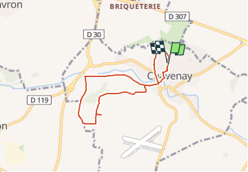
Randonnée Marche de 6,1 km à découvrir à Île-de-France, Yvelines, Chavenay. Cette randonnée est proposée par Rando MLC.
Description
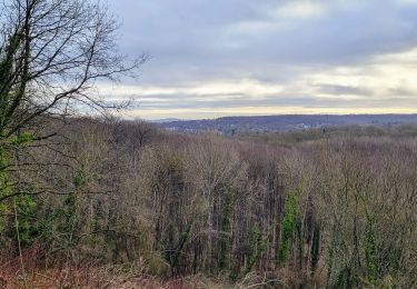
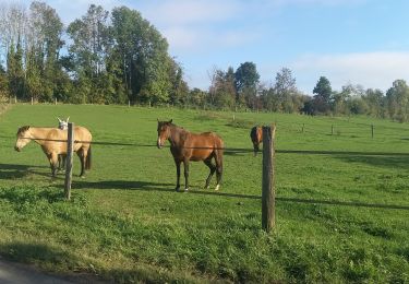
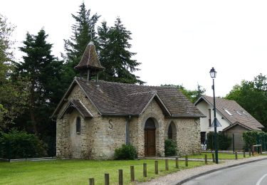
balade du mardi. Beaux points de vue sur Chavenay. Passage par l'église, le lavoir, les arches du puit carrier, le ru de Gally et l'étang de pêche.
Durée 1h50, vitesse de balade.
Localisation
Pays :
France
Région :
Île-de-France
Département/Province :
Yvelines
Commune :
Chavenay
Localité :
Unknown
Départ:(Dec)
Départ:(UTM)
425712 ; 5411853 (31U) N.
Commentaires
Randonnées à proximité
![Randonnée Marche L'Étang-la-Ville - GRP CV-IDF 02R L'Étang-la-Ville à Poissy - Photo](https://media.geolcdn.com/t/375/260/5b76ffb0-032e-4c30-9eff-c534da0117fa.jpg&format=jpg&maxdim=2)
![Marche Marche](https://static1.geolcdn.com/sitytour/trail-icons/101.png)
GRP CV-IDF 02R L'Étang-la-Ville à Poissy
Marche
Difficile
(1)
L'Étang-la-Ville,
Île-de-France,
Yvelines,
France
![](/images/other/stat-length.png)
10,7 km | 13,7 km-effort
3h 6min
![](https://static1.geolcdn.com/siteimages/upload/files/16400158638029165_repeat_loop_refresh_sync_direction_icon.png)
Non
![Randonnée Marche Plaisir - Plaisir et forêt de Ste Apolline - Photo](https://media.geolcdn.com/t/375/260/ext.jpg?maxdim=2&url=https%3A%2F%2Fservices.sitytrail.com%2FGeolivesWS%2FDownloadMedia.ashx%3FTrailID%3D317587%26Media%3D16850_6.jpg)
![Marche Marche](https://static1.geolcdn.com/sitytour/trail-icons/101.png)
Plaisir et forêt de Ste Apolline
Marche
Moyen
(2)
Plaisir,
Île-de-France,
Yvelines,
France
![](/images/other/stat-length.png)
12,7 km | 15,4 km-effort
2h 30min
![](https://static1.geolcdn.com/siteimages/upload/files/16400158638029165_repeat_loop_refresh_sync_direction_icon.png)
Oui
![Randonnée Marche Chambourcy - Ballade autour du golf de Chambourcy - Photo](https://media.geolcdn.com/t/375/260/ec912980-2058-4871-9f73-872617e204cc.jpg&format=jpg&maxdim=2)
![Marche Marche](https://static1.geolcdn.com/sitytour/trail-icons/101.png)
Ballade autour du golf de Chambourcy
Marche
Moyen
(1)
Chambourcy,
Île-de-France,
Yvelines,
France
![](/images/other/stat-length.png)
8,5 km | 10,6 km-effort
1h 55min
![](https://static1.geolcdn.com/siteimages/upload/files/16400158638029165_repeat_loop_refresh_sync_direction_icon.png)
Oui
![Randonnée Marche L'Étang-la-Ville - Gare de St Nom - Boucle nocturne Gr ~2h 8,5km - Photo](https://media.geolcdn.com/t/375/260/ext.jpg?maxdim=2&url=https%3A%2F%2Fstatic1.geolcdn.com%2Fsiteimages%2Fupload%2Ffiles%2F1553511878bg_sport_marche.png)
![Marche Marche](https://static1.geolcdn.com/sitytour/trail-icons/101.png)
Gare de St Nom - Boucle nocturne Gr ~2h 8,5km
Marche
Facile
(1)
L'Étang-la-Ville,
Île-de-France,
Yvelines,
France
![](/images/other/stat-length.png)
24 km | 28 km-effort
12h 14min
![](https://static1.geolcdn.com/siteimages/upload/files/16400158638029165_repeat_loop_refresh_sync_direction_icon.png)
Non
![Randonnée A pied L'Étang-la-Ville - Le tour du Grand Paris par le GR1 Etape 2 - Saint Nom la Bretèche - Triel sur Seine - Photo](https://media.geolcdn.com/t/375/260/1683ad58-8376-4601-9416-cabd4c0df082.jpg&format=jpg&maxdim=2)
![A pied A pied](https://static1.geolcdn.com/sitytour/trail-icons/100.png)
Le tour du Grand Paris par le GR1 Etape 2 - Saint Nom la Bretèche - Triel sur...
A pied
Difficile
L'Étang-la-Ville,
Île-de-France,
Yvelines,
France
![](/images/other/stat-length.png)
31 km | 36 km-effort
8h 16min
![](https://static1.geolcdn.com/siteimages/upload/files/16400158638029165_repeat_loop_refresh_sync_direction_icon.png)
Non
![Marche Marche](https://static1.geolcdn.com/sitytour/trail-icons/101.png)
2024-11-12-Rennemoulin-fontaine de Maltoute
Marche
Moyen
Rennemoulin,
Île-de-France,
Yvelines,
France
![](/images/other/stat-length.png)
6,6 km | 7,8 km-effort
1h 47min
![](https://static1.geolcdn.com/siteimages/upload/files/16400158638029165_repeat_loop_refresh_sync_direction_icon.png)
Oui
![Randonnée A pied Chavenay - PR - Photo](https://media.geolcdn.com/t/375/260/f8e6bd7a-5875-409f-a50f-40b8535a7dfc.jpeg&format=jpg&maxdim=2)
![A pied A pied](https://static1.geolcdn.com/sitytour/trail-icons/100.png)
![Randonnée Marche Chambourcy - Chambourcy - Photo](https://media.geolcdn.com/t/375/260/efbf95e6-3390-4a1a-ba61-bac933d8c681.jpg&format=jpg&maxdim=2)
![Marche Marche](https://static1.geolcdn.com/sitytour/trail-icons/101.png)
Chambourcy
Marche
Facile
Chambourcy,
Île-de-France,
Yvelines,
France
![](/images/other/stat-length.png)
9 km | 11,6 km-effort
3h 3min
![](https://static1.geolcdn.com/siteimages/upload/files/16400158638029165_repeat_loop_refresh_sync_direction_icon.png)
Oui
![Randonnée Marche L'Étang-la-Ville - Forêt de Marly - Photo](https://media.geolcdn.com/t/375/260/2acaf939-1c04-4175-a4e2-9c6944adf1a1.jpg&format=jpg&maxdim=2)
![Marche Marche](https://static1.geolcdn.com/sitytour/trail-icons/101.png)
Forêt de Marly
Marche
Facile
L'Étang-la-Ville,
Île-de-France,
Yvelines,
France
![](/images/other/stat-length.png)
6,8 km | 8,5 km-effort
2h 1min
![](https://static1.geolcdn.com/siteimages/upload/files/16400158638029165_repeat_loop_refresh_sync_direction_icon.png)
Oui