Randonnée Marche Saint-Symphorien - SAINT SYMPHORIEN 12km - Photo
 fanthou
fanthou

Utilisateur

© OpenStreetMap contributors
Longueur
Longueur
12,5 km
Altitude max
Altitude max
181 m
Dénivelé positif
Dénivelé positif
103 m
Km-Effort
Km-Effort  
13,9 km
Altitude min
Altitude min
140 m
Dénivelé négatif
Dénivelé négatif
103 m
Boucle
Boucle
Oui
Date de création :
2024-09-16 17:32:38.041
Dernière modification :
2024-09-16 17:33:08.547

(0 Avis)

Marche
Marche
3h08
Difficulté : Difficile

Scannez ce code QR pour ouvrir la randonnée dans l'application SityTrail

Application GPS de randonnée GRATUITE

Logo SityTrail SityTrail

IGN / Instituts géographiques

Télécharger SityTrail sur l'App Store Télécharger SityTrail sur Google Play

Logo SityTrail SityTrail World

Le monde est à vous

Télécharger SityTrail sur l'App Store Télécharger SityTrail sur Google Play Télécharger SityTrail sur Huawei AppGallery

À propos

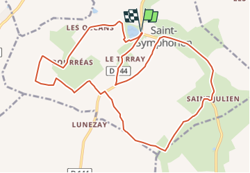
Randonnée Marche de 12,5 km à découvrir à Centre-Val de Loire, Cher, Saint-Symphorien. Cette randonnée est proposée par fanthou.

Profil altimétrique

Points d'intérêt

Point d'intérêt Saint-Symphorien - Faire le tour de l'étang pour rejoindre les Océans - Photo
fanthou
Point d'intérêt Saint-Symphorien - Croisement en T - Photo
fanthou
SAINT-SYMPHORIEN 
Point d'intérêt Saint-Symphorien - Les Occans - Photo
fanthou
SAINT-SYMPHORIEN 
Point d'intérêt Saint-Symphorien - Bourreas - Photo
fanthou
SAINT-SYMPHORIEN 
Point d'intérêt Saint-Symphorien - Sortie de Bourréas - Photo
fanthou
SAINT-SYMPHORIEN 
Point d'intérêt Saint-Symphorien - Petite route - Photo
fanthou
SAINT-SYMPHORIEN 
Point d'intérêt Saint-Symphorien - Croisement de routes en T - Photo
fanthou
SAINT-SYMPHORIEN 
Point d'intérêt Saint-Symphorien - Départ de chemin - Photo
fanthou
SAINT-SYMPHORIEN 
Point d'intérêt Saint-Symphorien - Chemin entre deux champs - Photo
fanthou
SAINT-SYMPHORIEN 
Point d'intérêt Saint-Symphorien - Rejoindre la côte 164 - Photo
fanthou
SAINT-SYMPHORIEN 
Point d'intérêt Saint-Symphorien - Intersection - Photo
fanthou
SAINT-SYMPHORIEN 
Point d'intérêt Saint-Symphorien - Gîte de St Julien - Photo
fanthou
SAINT-SYMPHORIEN 
Point d'intérêt Saint-Symphorien - Saint-Julien - Photo
fanthou
SAINT-SYMPHORIEN 
Point d'intérêt Saint-Symphorien - Bourg de St Symphorien - Photo
fanthou
SAINT-SYMPHORIEN 
Point d'intérêt Saint-Symphorien - Intersection - Photo
fanthou
SAINT-SYMPHORIEN 
Point d'intérêt Saint-Symphorien - Route indiquant Les Barges - Photo
fanthou
SAINT-SYMPHORIEN 
Point d'intérêt Saint-Symphorien - Route - Les Barges - Photo
fanthou
SAINT-SYMPHORIEN 
Point d'intérêt Saint-Symphorien - Le Terray - Photo
fanthou
SAINT-SYMPHORIEN 

Localisation

Pays :
France
Région :
Centre-Val de Loire
Département/Province :
Cher
Commune :
Saint-Symphorien
Localité :
Unknown
Départ:(Dec)
Départ:(UTM)
447047 ; 5184624 (31T) N.

Randonnées à proximité

Randonnée Marche Châteauneuf-sur-Cher - Le Cher majestueux à Châteauneuf sur Cher - Photo
Marche
tracegps

Marche

Difficile
(1)
Châteauneuf-sur-Cher, Centre-Val de Loire, Cher, France
23 km | 25 km-effort
5h 30min
Oui
Randonnée Cheval Châteauneuf-sur-Cher - Le Cher majestueux à Châteauneuf sur Cher - Photo
Cheval
tracegps

Cheval

Difficile
(1)
Châteauneuf-sur-Cher, Centre-Val de Loire, Cher, France
23 km | 25 km-effort
4h 0min
Oui
Randonnée V.T.T. Châteauneuf-sur-Cher - Le Cher majestueux à Châteauneuf sur Cher - Photo
V.T.T.
tracegps

V.T.T.

Difficile
Châteauneuf-sur-Cher, Centre-Val de Loire, Cher, France
23 km | 25 km-effort
2h 30min
Oui
Randonnée Trail Châteauneuf-sur-Cher - Châteauneuf sur cher - Photo
Trail
levequejef

Trail

Très facile
Châteauneuf-sur-Cher, Centre-Val de Loire, Cher, France
17,7 km | 20 km-effort
2h 17min
Oui
Randonnée Marche Venesmes - VENESMES 15km - Photo
Marche
fanthou

Marche

Difficile
Venesmes, Centre-Val de Loire, Cher, France
14,6 km | 16,3 km-effort
3h 42min
Oui
Randonnée Marche Châteauneuf-sur-Cher - CHATEAUNEUF SUR CHER 13km - Photo
Marche
fanthou

Marche

Difficile
Châteauneuf-sur-Cher, Centre-Val de Loire, Cher, France
13,4 km | 14,7 km-effort
3h 20min
Oui
Randonnée Marche Chambon - CHAMBON 9km - Photo
Marche
fanthou

Marche

Moyen
Chambon, Centre-Val de Loire, Cher, France
8,9 km | 9,9 km-effort
2h 15min
Oui
Randonnée Moto-cross Châteauneuf-sur-Cher - 2024-02 enduro venesme avec Cyril - Photo
Moto-cross
Crazytob

Moto-cross

Facile
Châteauneuf-sur-Cher, Centre-Val de Loire, Cher, France
33 km | 37 km-effort
1h 40min
Non
Randonnée Course à pied Châteauneuf-sur-Cher - château neuf sur cher  - Photo
Course à pied
levequejef

Course à pied

Très facile
Châteauneuf-sur-Cher, Centre-Val de Loire, Cher, France
23 km | 25 km-effort
3h 3min
Oui


Fermer
Mes abonnements