![](/images/other/stat-length.png)
![Randonnée Marche Goven - Circuit de l'Ermitage - Photo](https://media.geolcdn.com/t/1900/400/ext.pjpeg?maxdim=2&url=https%3A%2F%2Fstatic1.geolcdn.com%2Fsiteimages%2Fupload%2Ffiles%2F1553511878bg_sport_marche.png)
Circuit de l'Ermitage
Marie therese Marteau
Utilisateur
![Longueur](/images/other/stat-length.png)
Longueur
11,5 km
![Altitude max](https://static1.geolcdn.com/siteimages/upload/files/1508320355ic_sort_altitude_max_24dp.png)
Altitude max
117 m
![Dénivelé positif](https://static1.geolcdn.com/siteimages/upload/files/1508320355ic_sort_den_pos_24dp.png)
Dénivelé positif
140 m
![Km-Effort](/images/other/stat-length.png)
Km-Effort
13,4 km
![Altitude min](https://static1.geolcdn.com/siteimages/upload/files/1508320355ic_sort_altitude_min_24dp.png)
Altitude min
64 m
![Dénivelé négatif](https://static1.geolcdn.com/siteimages/upload/files/1508320355ic_sort_den_neg_24dp.png)
Dénivelé négatif
141 m
![Boucle](https://static1.geolcdn.com/siteimages/upload/files/16400158638029165_repeat_loop_refresh_sync_direction_icon.png)
Boucle
Oui
Date de création :
2024-09-15 12:17:35.134
Dernière modification :
2024-09-15 12:21:24.375
![Marche](https://static1.geolcdn.com/sitytour/trail-icons/101.png)
3h02
Difficulté : Difficile
![Scannez ce code QR pour ouvrir la randonnée dans l'application SityTrail](https://capi.geolives.com/qq0zvz2zws4bq2lad0pu/sitytour/trails/4190550/qr.png?size=200)
Application GPS de randonnée GRATUITE
À propos
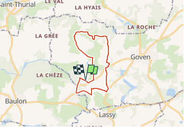
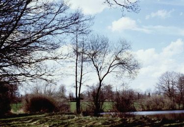
Randonnée Marche de 11,5 km à découvrir à Bretagne, Ille-et-Vilaine, Goven. Cette randonnée est proposée par Marie therese Marteau.
Description
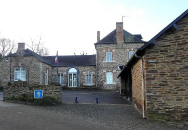
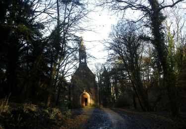
Point de départ, sur le parking près de La Chapelle de l'Ermitage
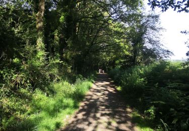
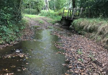
Direction la Denilais et La Chapelle de l'Hermitage
Localisation
Pays :
France
Région :
Bretagne
Département/Province :
Ille-et-Vilaine
Commune :
Goven
Localité :
Unknown
Départ:(Dec)
Départ:(UTM)
583242 ; 5316306 (30T) N.
Commentaires
Randonnées à proximité
![Randonnée Marche Lassy - canut - Photo](https://media.geolcdn.com/t/375/260/b8ca55a7-8b29-4af0-83f9-f3092173f4b9.jpg&format=jpg&maxdim=2)
![Marche Marche](https://static1.geolcdn.com/sitytour/trail-icons/101.png)
canut
Marche
Très facile
(1)
Lassy,
Bretagne,
Ille-et-Vilaine,
France
![](/images/other/stat-length.png)
3,6 km | 4,5 km-effort
57min
![](https://static1.geolcdn.com/siteimages/upload/files/16400158638029165_repeat_loop_refresh_sync_direction_icon.png)
Oui
![Randonnée Marche Lassy - Les landes de lassy - Photo](https://media.geolcdn.com/t/375/260/ext.jpg?maxdim=2&url=https%3A%2F%2Fstatic1.geolcdn.com%2Fsiteimages%2Fupload%2Ffiles%2F1553511878bg_sport_marche.png)
![Marche Marche](https://static1.geolcdn.com/sitytour/trail-icons/101.png)
Les landes de lassy
Marche
Facile
(2)
Lassy,
Bretagne,
Ille-et-Vilaine,
France
![](/images/other/stat-length.png)
8,7 km | 10,7 km-effort
2h 20min
![](https://static1.geolcdn.com/siteimages/upload/files/16400158638029165_repeat_loop_refresh_sync_direction_icon.png)
Oui
![Randonnée A pied Lassy - Circuit des Landes - Photo](https://media.geolcdn.com/t/375/260/7dd3c174-fffa-4d0a-9a6a-d8f005eae851.jpeg&format=jpg&maxdim=2)
![A pied A pied](https://static1.geolcdn.com/sitytour/trail-icons/100.png)
Circuit des Landes
A pied
Facile
Lassy,
Bretagne,
Ille-et-Vilaine,
France
![](/images/other/stat-length.png)
8,8 km | 10,9 km-effort
2h 28min
![](https://static1.geolcdn.com/siteimages/upload/files/16400158638029165_repeat_loop_refresh_sync_direction_icon.png)
Oui
![Randonnée A pied Lassy - Circuit des Ruisseaux - Photo](https://media.geolcdn.com/t/375/260/c6412dfd-75e1-4d50-a2a4-3347aade2a27.jpeg&format=jpg&maxdim=2)
![A pied A pied](https://static1.geolcdn.com/sitytour/trail-icons/100.png)
Circuit des Ruisseaux
A pied
Facile
Lassy,
Bretagne,
Ille-et-Vilaine,
France
![](/images/other/stat-length.png)
9,9 km | 12 km-effort
2h 44min
![](https://static1.geolcdn.com/siteimages/upload/files/16400158638029165_repeat_loop_refresh_sync_direction_icon.png)
Non
![Randonnée Cheval Lassy - Vallée du Ritoir et du Canut - Lassy - Photo](https://media.geolcdn.com/t/375/260/ext.jpg?maxdim=2&url=https%3A%2F%2Fservices.sitytrail.com%2FGeolivesWS%2FDownloadMedia.ashx%3FTrailID%3D317599%26Media%3D16867_3.jpg)
![Cheval Cheval](https://static1.geolcdn.com/sitytour/trail-icons/300.png)
Vallée du Ritoir et du Canut - Lassy
Cheval
Très difficile
(1)
Lassy,
Bretagne,
Ille-et-Vilaine,
France
![](/images/other/stat-length.png)
66 km | 78 km-effort
6h 30min
![](https://static1.geolcdn.com/siteimages/upload/files/16400158638029165_repeat_loop_refresh_sync_direction_icon.png)
Non
![Randonnée A pied Goven - La Lande de Caffort - Photo](https://media.geolcdn.com/t/375/260/ext.jpg?maxdim=2&url=https%3A%2F%2Fstatic1.geolcdn.com%2Fsiteimages%2Fupload%2Ffiles%2F1545311037marcheuse_200dpi.jpg)
![A pied A pied](https://static1.geolcdn.com/sitytour/trail-icons/100.png)
La Lande de Caffort
A pied
Facile
Goven,
Bretagne,
Ille-et-Vilaine,
France
![](/images/other/stat-length.png)
11,4 km | 13,2 km-effort
3h 0min
![](https://static1.geolcdn.com/siteimages/upload/files/16400158638029165_repeat_loop_refresh_sync_direction_icon.png)
Oui
![Randonnée Marche Baulon - 28.09.2019 - De Baulon-ouest à Maxent - Photo](https://media.geolcdn.com/t/375/260/76bdde4b-813d-4d31-9b59-f38b205d8ab9.jpg&format=jpg&maxdim=2)
![Marche Marche](https://static1.geolcdn.com/sitytour/trail-icons/101.png)
28.09.2019 - De Baulon-ouest à Maxent
Marche
Difficile
Baulon,
Bretagne,
Ille-et-Vilaine,
France
![](/images/other/stat-length.png)
30 km | 35 km-effort
8h 3min
![](https://static1.geolcdn.com/siteimages/upload/files/16400158638029165_repeat_loop_refresh_sync_direction_icon.png)
Oui
![Randonnée Marche Bréal-sous-Montfort - breal montfort13 11 22 - Photo](https://media.geolcdn.com/t/375/260/ext.jpg?maxdim=2&url=https%3A%2F%2Fstatic1.geolcdn.com%2Fsiteimages%2Fupload%2Ffiles%2F1553511878bg_sport_marche.png)
![Marche Marche](https://static1.geolcdn.com/sitytour/trail-icons/101.png)
breal montfort13 11 22
Marche
Moyen
Bréal-sous-Montfort,
Bretagne,
Ille-et-Vilaine,
France
![](/images/other/stat-length.png)
7,7 km | 8,6 km-effort
2h 22min
![](https://static1.geolcdn.com/siteimages/upload/files/16400158638029165_repeat_loop_refresh_sync_direction_icon.png)
Non
![Randonnée V.T.T. Goven - goven - Photo](https://media.geolcdn.com/t/375/260/49e21261-f5a3-4feb-b6dc-e8d458c15142.jpg&format=jpg&maxdim=2)
![V.T.T. V.T.T.](https://static1.geolcdn.com/sitytour/trail-icons/202.png)