![](/images/other/stat-length.png)
![Randonnée Marche Sixt-Fer-à-Cheval - Le tour des Fiz : J3 - Photo](https://media.geolcdn.com/t/1900/400/9c7228c0-b1d1-422d-97b7-6cc678ab62a3.jpg&format=pjpeg&maxdim=2)
Le tour des Fiz : J3
Greg813
Utilisateur
![Longueur](/images/other/stat-length.png)
Longueur
10,8 km
![Altitude max](https://static1.geolcdn.com/siteimages/upload/files/1508320355ic_sort_altitude_max_24dp.png)
Altitude max
2350 m
![Dénivelé positif](https://static1.geolcdn.com/siteimages/upload/files/1508320355ic_sort_den_pos_24dp.png)
Dénivelé positif
619 m
![Km-Effort](/images/other/stat-length.png)
Km-Effort
21 km
![Altitude min](https://static1.geolcdn.com/siteimages/upload/files/1508320355ic_sort_altitude_min_24dp.png)
Altitude min
1234 m
![Dénivelé négatif](https://static1.geolcdn.com/siteimages/upload/files/1508320355ic_sort_den_neg_24dp.png)
Dénivelé négatif
1140 m
![Boucle](https://static1.geolcdn.com/siteimages/upload/files/16400158638029165_repeat_loop_refresh_sync_direction_icon.png)
Boucle
Non
Date de création :
2024-09-10 05:28:16.692
Dernière modification :
2024-09-15 07:31:37.991
![Marche](https://static1.geolcdn.com/sitytour/trail-icons/101.png)
3h24
Difficulté : Moyen
![Scannez ce code QR pour ouvrir la randonnée dans l'application SityTrail](https://capi.geolives.com/qq0zvz2zws4bq2lad0pu/sitytour/trails/4185144/qr.png?size=200)
Application GPS de randonnée GRATUITE
À propos
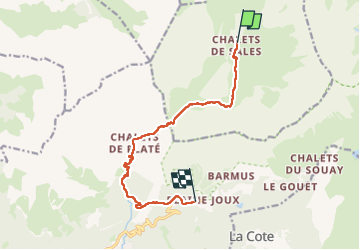
Randonnée Marche de 10,8 km à découvrir à Auvergne-Rhône-Alpes, Haute-Savoie, Sixt-Fer-à-Cheval. Cette randonnée est proposée par Greg813.
Description
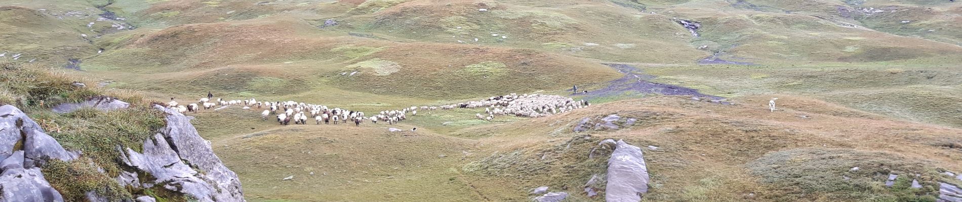
Trek de 3 jours dans le massif des Fiz.
Etape 3 : Du refuge de Sales à Plaine Joux, par le désert de Platé et le col de la Portette.
Localisation
Pays :
France
Région :
Auvergne-Rhône-Alpes
Département/Province :
Haute-Savoie
Commune :
Sixt-Fer-à-Cheval
Localité :
Unknown
Départ:(Dec)
Départ:(UTM)
325939 ; 5095292 (32T) N.
Commentaires
Randonnées à proximité
![Randonnée Marche Passy - Tour des Ayères - Passy Plaine-Joux - Photo](https://media.geolcdn.com/t/375/260/ext.jpg?maxdim=2&url=https%3A%2F%2Fservices.sitytrail.com%2FGeolivesWS%2FDownloadMedia.ashx%3FTrailID%3D172972%26Media%3D14459_6.jpg)
![Marche Marche](https://static1.geolcdn.com/sitytour/trail-icons/101.png)
Tour des Ayères - Passy Plaine-Joux
Marche
Moyen
(6)
Passy,
Auvergne-Rhône-Alpes,
Haute-Savoie,
France
![](/images/other/stat-length.png)
9 km | 14,3 km-effort
2h 30min
![](https://static1.geolcdn.com/siteimages/upload/files/16400158638029165_repeat_loop_refresh_sync_direction_icon.png)
Oui
![Randonnée Marche Passy - J10 - R8 - Plaine Joux - Les Ayères - Lac Vert - Photo](https://media.geolcdn.com/t/375/260/9c4651a9-0301-4065-a6bf-57814595ef3e.jpg&format=jpg&maxdim=2)
![Marche Marche](https://static1.geolcdn.com/sitytour/trail-icons/101.png)
J10 - R8 - Plaine Joux - Les Ayères - Lac Vert
Marche
Moyen
(1)
Passy,
Auvergne-Rhône-Alpes,
Haute-Savoie,
France
![](/images/other/stat-length.png)
10,5 km | 16,1 km-effort
3h 4min
![](https://static1.geolcdn.com/siteimages/upload/files/16400158638029165_repeat_loop_refresh_sync_direction_icon.png)
Oui
![Randonnée Marche Passy - Plaine Joux Barmus Ayères Lac Vert - Photo](https://media.geolcdn.com/t/375/260/231e6d97-0ab1-4400-9dc1-f2b1dbc1d2c1.jpg&format=jpg&maxdim=2)
![Marche Marche](https://static1.geolcdn.com/sitytour/trail-icons/101.png)
Plaine Joux Barmus Ayères Lac Vert
Marche
Très facile
(1)
Passy,
Auvergne-Rhône-Alpes,
Haute-Savoie,
France
![](/images/other/stat-length.png)
7,6 km | 12,2 km-effort
2h 18min
![](https://static1.geolcdn.com/siteimages/upload/files/16400158638029165_repeat_loop_refresh_sync_direction_icon.png)
Oui
![Randonnée Marche Sixt-Fer-à-Cheval - Lac d'Anterne - Photo](https://media.geolcdn.com/t/375/260/ext.jpg?maxdim=2&url=https%3A%2F%2Fservices.sitytrail.com%2FGeolivesWS%2FDownloadMedia.ashx%3FTrailID%3D219373%26Media%3Dfix__20130905155735.jpg)
![Marche Marche](https://static1.geolcdn.com/sitytour/trail-icons/101.png)
Lac d'Anterne
Marche
Moyen
(1)
Sixt-Fer-à-Cheval,
Auvergne-Rhône-Alpes,
Haute-Savoie,
France
![](/images/other/stat-length.png)
19,8 km | 37 km-effort
5h 9min
![](https://static1.geolcdn.com/siteimages/upload/files/16400158638029165_repeat_loop_refresh_sync_direction_icon.png)
Oui
![Randonnée Marche Magland - belvédère d Aulp - Photo](https://media.geolcdn.com/t/375/260/3d7c42d4-f0a9-4769-9285-e47bef46b3ca.jpg&format=jpg&maxdim=2)
![Marche Marche](https://static1.geolcdn.com/sitytour/trail-icons/101.png)
belvédère d Aulp
Marche
Difficile
Magland,
Auvergne-Rhône-Alpes,
Haute-Savoie,
France
![](/images/other/stat-length.png)
7,7 km | 14,1 km-effort
4h 2min
![](https://static1.geolcdn.com/siteimages/upload/files/16400158638029165_repeat_loop_refresh_sync_direction_icon.png)
Oui
![Randonnée Marche Sixt-Fer-à-Cheval - 2020-08-15 Marche Refuge Grenairon Le Mont Buet Les Fonts Salvagny - Photo](https://media.geolcdn.com/t/375/260/e7db8eb5-0ce5-4100-b4bb-95b4993ccdfd.jpg&format=jpg&maxdim=2)
![Marche Marche](https://static1.geolcdn.com/sitytour/trail-icons/101.png)
2020-08-15 Marche Refuge Grenairon Le Mont Buet Les Fonts Salvagny
Marche
Très facile
Sixt-Fer-à-Cheval,
Auvergne-Rhône-Alpes,
Haute-Savoie,
France
![](/images/other/stat-length.png)
20 km | 40 km-effort
12h 24min
![](https://static1.geolcdn.com/siteimages/upload/files/16400158638029165_repeat_loop_refresh_sync_direction_icon.png)
Non
![Randonnée Marche Passy - Plaine Joux-Passage du derochoir-Col de Portette-Platé - Photo](https://media.geolcdn.com/t/375/260/a1a5c98a-bca0-41f5-b9f9-06d73967e2da.jpg&format=jpg&maxdim=2)
![Marche Marche](https://static1.geolcdn.com/sitytour/trail-icons/101.png)
Plaine Joux-Passage du derochoir-Col de Portette-Platé
Marche
Difficile
Passy,
Auvergne-Rhône-Alpes,
Haute-Savoie,
France
![](/images/other/stat-length.png)
14,4 km | 30 km-effort
6h 42min
![](https://static1.geolcdn.com/siteimages/upload/files/16400158638029165_repeat_loop_refresh_sync_direction_icon.png)
Oui
![Randonnée Marche Passy - J27 - R25 - 🍂🍁 Plaine-Joux - Les Ayères - Lac Vert 🍁🍂
- Photo](https://media.geolcdn.com/t/375/260/b4952294-3c09-42c8-ac3d-e0aea2d811d5.jpg&format=jpg&maxdim=2)
![Marche Marche](https://static1.geolcdn.com/sitytour/trail-icons/101.png)
J27 - R25 - 🍂🍁 Plaine-Joux - Les Ayères - Lac Vert 🍁🍂
Marche
Moyen
Passy,
Auvergne-Rhône-Alpes,
Haute-Savoie,
France
![](/images/other/stat-length.png)
10 km | 15,5 km-effort
2h 52min
![](https://static1.geolcdn.com/siteimages/upload/files/16400158638029165_repeat_loop_refresh_sync_direction_icon.png)
Oui
![Randonnée Marche Passy - Le tour des Fiz : J2 - Photo](https://media.geolcdn.com/t/375/260/939b6d9f-8ec5-49fa-ac5f-683b426f45bd.jpg&format=jpg&maxdim=2)
![Marche Marche](https://static1.geolcdn.com/sitytour/trail-icons/101.png)
Le tour des Fiz : J2
Marche
Difficile
Passy,
Auvergne-Rhône-Alpes,
Haute-Savoie,
France
![](/images/other/stat-length.png)
15,7 km | 31 km-effort
4h 41min
![](https://static1.geolcdn.com/siteimages/upload/files/16400158638029165_repeat_loop_refresh_sync_direction_icon.png)
Non