![](/images/other/stat-length.png)
![Randonnée Marche Bettancourt-la-Ferrée - Bett stade Bernard - Photo](https://media.geolcdn.com/t/1900/400/ext.pjpeg?maxdim=2&url=https%3A%2F%2Fstatic1.geolcdn.com%2Fsiteimages%2Fupload%2Ffiles%2F1553511878bg_sport_marche.png)
Bett stade Bernard
Monique KOVAC
Utilisateur
![Longueur](/images/other/stat-length.png)
Longueur
8,9 km
![Altitude max](https://static1.geolcdn.com/siteimages/upload/files/1508320355ic_sort_altitude_max_24dp.png)
Altitude max
203 m
![Dénivelé positif](https://static1.geolcdn.com/siteimages/upload/files/1508320355ic_sort_den_pos_24dp.png)
Dénivelé positif
93 m
![Km-Effort](/images/other/stat-length.png)
Km-Effort
10,1 km
![Altitude min](https://static1.geolcdn.com/siteimages/upload/files/1508320355ic_sort_altitude_min_24dp.png)
Altitude min
155 m
![Dénivelé négatif](https://static1.geolcdn.com/siteimages/upload/files/1508320355ic_sort_den_neg_24dp.png)
Dénivelé négatif
93 m
![Boucle](https://static1.geolcdn.com/siteimages/upload/files/16400158638029165_repeat_loop_refresh_sync_direction_icon.png)
Boucle
Oui
Date de création :
2024-09-09 11:48:30.0
Dernière modification :
2024-09-09 14:35:52.998
![Marche](https://static1.geolcdn.com/sitytour/trail-icons/101.png)
2h46
Difficulté : Inconnu
![Scannez ce code QR pour ouvrir la randonnée dans l'application SityTrail](https://capi.geolives.com/qq0zvz2zws4bq2lad0pu/sitytour/trails/4184061/qr.png?size=200)
Application GPS de randonnée GRATUITE
À propos
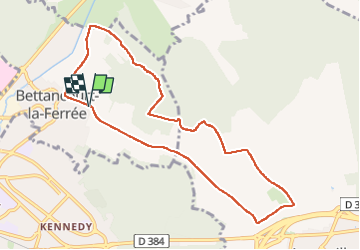
Randonnée Marche de 8,9 km à découvrir à Grand Est, Haute-Marne, Bettancourt-la-Ferrée. Cette randonnée est proposée par Monique KOVAC.
Description
Averses pluie. Chemin blanc caillouteux. Puis sentiers bois, retour sortie Chancenay descente du bois, voie cyclable, retour par cimetière.
Localisation
Pays :
France
Région :
Grand Est
Département/Province :
Haute-Marne
Commune :
Bettancourt-la-Ferrée
Localité :
Unknown
Départ:(Dec)
Départ:(UTM)
645848 ; 5390714 (31U) N.
Commentaires
Randonnées à proximité
![Randonnée Marche Ancerville - anceevilleforet de valtiermont - Photo](https://media.geolcdn.com/t/375/260/de42919c-f09a-46b1-b203-99237f391569.jpg&format=jpg&maxdim=2)
![Marche Marche](https://static1.geolcdn.com/sitytour/trail-icons/101.png)
anceevilleforet de valtiermont
Marche
Facile
Ancerville,
Grand Est,
Meuse,
France
![](/images/other/stat-length.png)
9,1 km | 10,5 km-effort
2h 46min
![](https://static1.geolcdn.com/siteimages/upload/files/16400158638029165_repeat_loop_refresh_sync_direction_icon.png)
Oui
![Randonnée Vélo de route Saint-Dizier - St Dizier/La Bresse - Photo](https://media.geolcdn.com/t/375/260/ext.jpg?maxdim=2&url=https%3A%2F%2Fstatic1.geolcdn.com%2Fsiteimages%2Fupload%2Ffiles%2F1524743154velo.jpg)
![Vélo de route Vélo de route](https://static1.geolcdn.com/sitytour/trail-icons/201.png)
St Dizier/La Bresse
Vélo de route
Saint-Dizier,
Grand Est,
Haute-Marne,
France
![](/images/other/stat-length.png)
182 km | 210 km-effort
3h 3min
![](https://static1.geolcdn.com/siteimages/upload/files/16400158638029165_repeat_loop_refresh_sync_direction_icon.png)
Non
![Randonnée Marche Ancerville - Ancerville Chevreuils Annick - Photo](https://media.geolcdn.com/t/375/260/ext.jpg?maxdim=2&url=https%3A%2F%2Fstatic1.geolcdn.com%2Fsiteimages%2Fupload%2Ffiles%2F1553511878bg_sport_marche.png)
![Marche Marche](https://static1.geolcdn.com/sitytour/trail-icons/101.png)
Ancerville Chevreuils Annick
Marche
Ancerville,
Grand Est,
Meuse,
France
![](/images/other/stat-length.png)
8,8 km | 10,3 km-effort
2h 33min
![](https://static1.geolcdn.com/siteimages/upload/files/16400158638029165_repeat_loop_refresh_sync_direction_icon.png)
Oui
![Randonnée Marche Saint-Dizier - Seule dimanche matin - Photo](https://media.geolcdn.com/t/375/260/ext.jpg?maxdim=2&url=https%3A%2F%2Fstatic1.geolcdn.com%2Fsiteimages%2Fupload%2Ffiles%2F1553511878bg_sport_marche.png)
![Marche Marche](https://static1.geolcdn.com/sitytour/trail-icons/101.png)
Seule dimanche matin
Marche
Saint-Dizier,
Grand Est,
Haute-Marne,
France
![](/images/other/stat-length.png)
9,8 km | 10,5 km-effort
3h 27min
![](https://static1.geolcdn.com/siteimages/upload/files/16400158638029165_repeat_loop_refresh_sync_direction_icon.png)
Oui
![Randonnée Marche Bettancourt-la-Ferrée - Bettancourt cimetière petite marche - Photo](https://media.geolcdn.com/t/375/260/ext.jpg?maxdim=2&url=https%3A%2F%2Fstatic1.geolcdn.com%2Fsiteimages%2Fupload%2Ffiles%2F1553511878bg_sport_marche.png)
![Marche Marche](https://static1.geolcdn.com/sitytour/trail-icons/101.png)
Bettancourt cimetière petite marche
Marche
Bettancourt-la-Ferrée,
Grand Est,
Haute-Marne,
France
![](/images/other/stat-length.png)
6,5 km | 7,9 km-effort
2h 1min
![](https://static1.geolcdn.com/siteimages/upload/files/16400158638029165_repeat_loop_refresh_sync_direction_icon.png)
Oui
![Randonnée Marche Chancenay - Chancenay stade petite marche - Photo](https://media.geolcdn.com/t/375/260/ext.jpg?maxdim=2&url=https%3A%2F%2Fstatic1.geolcdn.com%2Fsiteimages%2Fupload%2Ffiles%2F1553511878bg_sport_marche.png)
![Marche Marche](https://static1.geolcdn.com/sitytour/trail-icons/101.png)
Chancenay stade petite marche
Marche
Chancenay,
Grand Est,
Haute-Marne,
France
![](/images/other/stat-length.png)
6 km | 6,8 km-effort
2h 6min
![](https://static1.geolcdn.com/siteimages/upload/files/16400158638029165_repeat_loop_refresh_sync_direction_icon.png)
Oui
![Randonnée Marche Chancenay - Chancenay écoles Dominique belle marche brumeux pas de pluie - Photo](https://media.geolcdn.com/t/375/260/ext.jpg?maxdim=2&url=https%3A%2F%2Fstatic1.geolcdn.com%2Fsiteimages%2Fupload%2Ffiles%2F1553511878bg_sport_marche.png)
![Marche Marche](https://static1.geolcdn.com/sitytour/trail-icons/101.png)
Chancenay écoles Dominique belle marche brumeux pas de pluie
Marche
Chancenay,
Grand Est,
Haute-Marne,
France
![](/images/other/stat-length.png)
10,6 km | 12,3 km-effort
3h 3min
![](https://static1.geolcdn.com/siteimages/upload/files/16400158638029165_repeat_loop_refresh_sync_direction_icon.png)
Oui
![Randonnée Marche Saint-Dizier - Stade Nadine belle marche - Photo](https://media.geolcdn.com/t/375/260/ext.jpg?maxdim=2&url=https%3A%2F%2Fstatic1.geolcdn.com%2Fsiteimages%2Fupload%2Ffiles%2F1553511878bg_sport_marche.png)
![Marche Marche](https://static1.geolcdn.com/sitytour/trail-icons/101.png)
Stade Nadine belle marche
Marche
Saint-Dizier,
Grand Est,
Haute-Marne,
France
![](/images/other/stat-length.png)
9,4 km | 10,9 km-effort
2h 40min
![](https://static1.geolcdn.com/siteimages/upload/files/16400158638029165_repeat_loop_refresh_sync_direction_icon.png)
Oui
![Randonnée Marche Saint-Dizier - Marnaval église Claude - Photo](https://media.geolcdn.com/t/375/260/ext.jpg?maxdim=2&url=https%3A%2F%2Fstatic1.geolcdn.com%2Fsiteimages%2Fupload%2Ffiles%2F1553511878bg_sport_marche.png)
![Marche Marche](https://static1.geolcdn.com/sitytour/trail-icons/101.png)
Marnaval église Claude
Marche
Saint-Dizier,
Grand Est,
Haute-Marne,
France
![](/images/other/stat-length.png)
8,3 km | 10,3 km-effort
2h 43min
![](https://static1.geolcdn.com/siteimages/upload/files/16400158638029165_repeat_loop_refresh_sync_direction_icon.png)
Oui