![](/images/other/stat-length.png)
![Randonnée Marche Saint-Quentin-en-Tourmont - MARQUENTERRE: reconnaissance / départ du tour (16 Km) via la plage... - Photo](https://media.geolcdn.com/t/1900/400/47670b32-50c3-447c-807e-3b4b373f6a4d.jpg&format=pjpeg&maxdim=2)
MARQUENTERRE: reconnaissance / départ du tour (16 Km) via la plage...
djeepee74
Utilisateur
![Longueur](/images/other/stat-length.png)
Longueur
6,4 km
![Altitude max](https://static1.geolcdn.com/siteimages/upload/files/1508320355ic_sort_altitude_max_24dp.png)
Altitude max
13 m
![Dénivelé positif](https://static1.geolcdn.com/siteimages/upload/files/1508320355ic_sort_den_pos_24dp.png)
Dénivelé positif
26 m
![Km-Effort](/images/other/stat-length.png)
Km-Effort
6,7 km
![Altitude min](https://static1.geolcdn.com/siteimages/upload/files/1508320355ic_sort_altitude_min_24dp.png)
Altitude min
5 m
![Dénivelé négatif](https://static1.geolcdn.com/siteimages/upload/files/1508320355ic_sort_den_neg_24dp.png)
Dénivelé négatif
26 m
![Boucle](https://static1.geolcdn.com/siteimages/upload/files/16400158638029165_repeat_loop_refresh_sync_direction_icon.png)
Boucle
Oui
Date de création :
2024-09-04 16:03:32.917
Dernière modification :
2024-09-08 13:35:44.984
![Marche](https://static1.geolcdn.com/sitytour/trail-icons/101.png)
1h31
Difficulté : Moyen
![Scannez ce code QR pour ouvrir la randonnée dans l'application SityTrail](https://capi.geolives.com/qq0zvz2zws4bq2lad0pu/sitytour/trails/4179101/qr.png?size=200)
Application GPS de randonnée GRATUITE
À propos
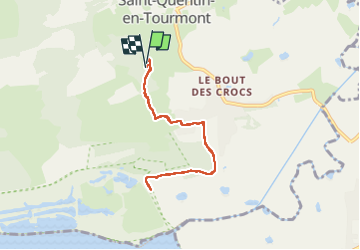
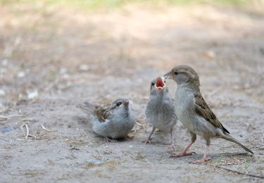
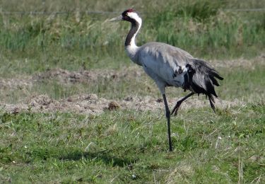
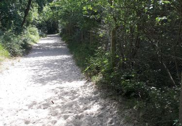
Randonnée Marche de 6,4 km à découvrir à Hauts-de-France, Somme, Saint-Quentin-en-Tourmont. Cette randonnée est proposée par djeepee74.
Description
A/R ... live du 20240904
Tous les chemins ou sentiers du lieu-dit " la Mouillerette " sont privés et en espace fermé, clôturant le "Parc du Marquenterre".
Localisation
Pays :
France
Région :
Hauts-de-France
Département/Province :
Somme
Commune :
Saint-Quentin-en-Tourmont
Localité :
Unknown
Départ:(Dec)
Départ:(UTM)
399361 ; 5570167 (31U) N.
Commentaires
Randonnées à proximité
![Randonnée Marche Le Crotoy - LP80_LaMaye_Reserve-du-Marquenterre_6km - Photo](https://media.geolcdn.com/t/375/260/cef91e86-689f-4bd7-8591-33e387b29cb5.jpg&format=jpg&maxdim=2)
![Marche Marche](https://static1.geolcdn.com/sitytour/trail-icons/101.png)
LP80_LaMaye_Reserve-du-Marquenterre_6km
Marche
Moyen
(2)
Le Crotoy,
Hauts-de-France,
Somme,
France
![](/images/other/stat-length.png)
6 km | 6,1 km-effort
1h 23min
![](https://static1.geolcdn.com/siteimages/upload/files/16400158638029165_repeat_loop_refresh_sync_direction_icon.png)
Oui
![Randonnée Marche Quend - Le Colombier - Photo](https://media.geolcdn.com/t/375/260/ext.jpg?maxdim=2&url=https%3A%2F%2Fservices.sitytrail.com%2FGeolivesWS%2FDownloadMedia.ashx%3FTrailID%3D108606%26Media%3D1514_1.jpg)
![Marche Marche](https://static1.geolcdn.com/sitytour/trail-icons/101.png)
Le Colombier
Marche
Difficile
(2)
Quend,
Hauts-de-France,
Somme,
France
![](/images/other/stat-length.png)
9,9 km | 10,5 km-effort
3h 19min
![](https://static1.geolcdn.com/siteimages/upload/files/16400158638029165_repeat_loop_refresh_sync_direction_icon.png)
Oui
![Randonnée Marche Saint-Quentin-en-Tourmont - Les crocs - Saint Quentin en Tourmont - Photo](https://media.geolcdn.com/t/375/260/ext.jpg?maxdim=2&url=https%3A%2F%2Fservices.sitytrail.com%2FGeolivesWS%2FDownloadMedia.ashx%3FTrailID%3D108604%26Media%3D1512_1.jpg)
![Marche Marche](https://static1.geolcdn.com/sitytour/trail-icons/101.png)
Les crocs - Saint Quentin en Tourmont
Marche
Difficile
(4)
Saint-Quentin-en-Tourmont,
Hauts-de-France,
Somme,
France
![](/images/other/stat-length.png)
15,8 km | 16,9 km-effort
5h 30min
![](https://static1.geolcdn.com/siteimages/upload/files/16400158638029165_repeat_loop_refresh_sync_direction_icon.png)
Oui
![Randonnée Cheval Le Crotoy - de la Maye vers marquenterre - Photo](https://media.geolcdn.com/t/375/260/ext.jpg?maxdim=2&url=https%3A%2F%2Fstatic1.geolcdn.com%2Fsiteimages%2Fupload%2Ffiles%2F1524743154cheval.jpg)
![Cheval Cheval](https://static1.geolcdn.com/sitytour/trail-icons/300.png)
de la Maye vers marquenterre
Cheval
Très facile
(4)
Le Crotoy,
Hauts-de-France,
Somme,
France
![](/images/other/stat-length.png)
20 km | 21 km-effort
2h 43min
![](https://static1.geolcdn.com/siteimages/upload/files/16400158638029165_repeat_loop_refresh_sync_direction_icon.png)
Non
![Randonnée Marche Le Crotoy - La Maille - Pointe de St Quentin - Photo](https://media.geolcdn.com/t/375/260/3398be8c-4fd8-4935-b428-3382873060ae.jpg&format=jpg&maxdim=2)
![Marche Marche](https://static1.geolcdn.com/sitytour/trail-icons/101.png)
La Maille - Pointe de St Quentin
Marche
Moyen
Le Crotoy,
Hauts-de-France,
Somme,
France
![](/images/other/stat-length.png)
9 km | 9,1 km-effort
4h 30min
![](https://static1.geolcdn.com/siteimages/upload/files/16400158638029165_repeat_loop_refresh_sync_direction_icon.png)
Oui
![Randonnée Marche Quend - dixk-mônchaux - Photo](https://media.geolcdn.com/t/375/260/0c33e945-d50d-4b4a-bef0-ad25dd476496.jpg&format=jpg&maxdim=2)
![Marche Marche](https://static1.geolcdn.com/sitytour/trail-icons/101.png)
dixk-mônchaux
Marche
Moyen
Quend,
Hauts-de-France,
Somme,
France
![](/images/other/stat-length.png)
11,4 km | 12 km-effort
2h 17min
![](https://static1.geolcdn.com/siteimages/upload/files/16400158638029165_repeat_loop_refresh_sync_direction_icon.png)
Non
![Randonnée A pied Quend - Le Colombier - Photo](https://media.geolcdn.com/t/375/260/716ce54f-89a0-4335-b6e0-2d178a29836d.jpeg&format=jpg&maxdim=2)
![A pied A pied](https://static1.geolcdn.com/sitytour/trail-icons/100.png)
Le Colombier
A pied
Facile
Quend,
Hauts-de-France,
Somme,
France
![](/images/other/stat-length.png)
9,9 km | 10,4 km-effort
2h 22min
![](https://static1.geolcdn.com/siteimages/upload/files/16400158638029165_repeat_loop_refresh_sync_direction_icon.png)
Oui
![Randonnée A pied - Les Crocs - Photo](https://media.geolcdn.com/t/375/260/edc33d6b-f7f4-4df4-988f-507b11ec46ba.jpeg&format=jpg&maxdim=2)
![A pied A pied](https://static1.geolcdn.com/sitytour/trail-icons/100.png)
![Randonnée Marche Saint-Quentin-en-Tourmont - chemin du littoral - Photo](https://media.geolcdn.com/t/375/260/f76ad346-696d-4bdc-b9e1-ffa0c4856a8a.jpg&format=jpg&maxdim=2)
![Marche Marche](https://static1.geolcdn.com/sitytour/trail-icons/101.png)
chemin du littoral
Marche
Moyen
Saint-Quentin-en-Tourmont,
Hauts-de-France,
Somme,
France
![](/images/other/stat-length.png)
6,5 km | 7,3 km-effort
2h 13min
![](https://static1.geolcdn.com/siteimages/upload/files/16400158638029165_repeat_loop_refresh_sync_direction_icon.png)
Oui