![](/images/other/stat-length.png)
![Randonnée A pied Espenel - Espenel de la Drome au col du grand pres - Photo](https://media.geolcdn.com/t/1900/400/17336f50-d28b-47d5-9d84-1ae67f524838.jpg&format=pjpeg&maxdim=2)
Espenel de la Drome au col du grand pres
Mich&Agnès
Utilisateur
![Longueur](/images/other/stat-length.png)
Longueur
6,6 km
![Altitude max](https://static1.geolcdn.com/siteimages/upload/files/1508320355ic_sort_altitude_max_24dp.png)
Altitude max
577 m
![Dénivelé positif](https://static1.geolcdn.com/siteimages/upload/files/1508320355ic_sort_den_pos_24dp.png)
Dénivelé positif
306 m
![Km-Effort](/images/other/stat-length.png)
Km-Effort
10,7 km
![Altitude min](https://static1.geolcdn.com/siteimages/upload/files/1508320355ic_sort_altitude_min_24dp.png)
Altitude min
275 m
![Dénivelé négatif](https://static1.geolcdn.com/siteimages/upload/files/1508320355ic_sort_den_neg_24dp.png)
Dénivelé négatif
306 m
![Boucle](https://static1.geolcdn.com/siteimages/upload/files/16400158638029165_repeat_loop_refresh_sync_direction_icon.png)
Boucle
Oui
Date de création :
2024-08-28 16:45:26.801
Dernière modification :
2024-08-28 17:12:10.852
![A pied](https://static1.geolcdn.com/sitytour/trail-icons/100.png)
2h25
Difficulté : Facile
![Scannez ce code QR pour ouvrir la randonnée dans l'application SityTrail](https://capi.geolives.com/qq0zvz2zws4bq2lad0pu/sitytour/trails/4171643/qr.png?size=200)
Application GPS de randonnée GRATUITE
À propos
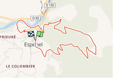
Randonnée A pied de 6,6 km à découvrir à Auvergne-Rhône-Alpes, Drôme, Espenel. Cette randonnée est proposée par Mich&Agnès.
Description
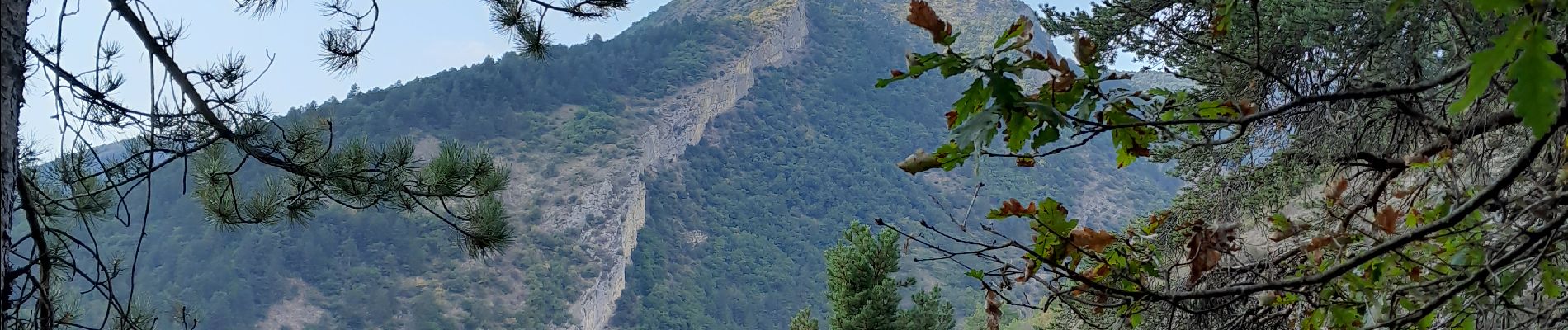
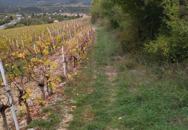
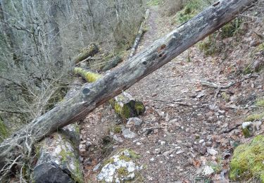
Balade en descendant tremper les pieds dans la Drôme (attention nous sommes remontés le long de la voie de chemin de fer : pas conseillé!), puis un tour sur les hauteur en face du village jusqu'au col du grand prés.
Localisation
Pays :
France
Région :
Auvergne-Rhône-Alpes
Département/Province :
Drôme
Commune :
Espenel
Localité :
Unknown
Départ:(Dec)
Départ:(UTM)
677156 ; 4950326 (31T) N.
Commentaires
Randonnées à proximité
![Randonnée Marche Saillans - Saillans Chapelle St Christophe 14km. - Photo](https://media.geolcdn.com/t/375/260/dbc3dc28-619e-4ea9-9959-103bf755836c.jpg&format=jpg&maxdim=2)
![Marche Marche](https://static1.geolcdn.com/sitytour/trail-icons/101.png)
Saillans Chapelle St Christophe 14km.
Marche
Moyen
(1)
Saillans,
Auvergne-Rhône-Alpes,
Drôme,
France
![](/images/other/stat-length.png)
14,1 km | 20 km-effort
4h 42min
![](https://static1.geolcdn.com/siteimages/upload/files/16400158638029165_repeat_loop_refresh_sync_direction_icon.png)
Oui
![Randonnée Marche Vercheny - Vercheny Chateau du Barry 14 km - Photo](https://media.geolcdn.com/t/375/260/519ec2eb-eec0-4702-a29a-2c5cd69166ae.jpg&format=jpg&maxdim=2)
![Marche Marche](https://static1.geolcdn.com/sitytour/trail-icons/101.png)
Vercheny Chateau du Barry 14 km
Marche
Moyen
(1)
Vercheny,
Auvergne-Rhône-Alpes,
Drôme,
France
![](/images/other/stat-length.png)
14,2 km | 23 km-effort
5h 11min
![](https://static1.geolcdn.com/siteimages/upload/files/16400158638029165_repeat_loop_refresh_sync_direction_icon.png)
Oui
![Randonnée V.T.T. Saillans - Grande Traversée des PréAlpes à VTT : variante Saillans - Montmorin - Photo](https://media.geolcdn.com/t/375/260/ext.jpg?maxdim=2&url=https%3A%2F%2Fservices.sitytrail.com%2FGeolivesWS%2FDownloadMedia.ashx%3FTrailID%3D102178%26Media%3D2569_1.jpg)
![V.T.T. V.T.T.](https://static1.geolcdn.com/sitytour/trail-icons/202.png)
Grande Traversée des PréAlpes à VTT : variante Saillans - Montmorin
V.T.T.
Très difficile
(1)
Saillans,
Auvergne-Rhône-Alpes,
Drôme,
France
![](/images/other/stat-length.png)
74 km | 113 km-effort
11h 0min
![](https://static1.geolcdn.com/siteimages/upload/files/16400158638029165_repeat_loop_refresh_sync_direction_icon.png)
Non
![Randonnée Marche Aurel - Vercors - Vercheny Combe Noire - Photo](https://media.geolcdn.com/t/375/260/ext.jpg?maxdim=2&url=https%3A%2F%2Fstatic1.geolcdn.com%2Fsiteimages%2Fupload%2Ffiles%2F1553511878bg_sport_marche.png)
![Marche Marche](https://static1.geolcdn.com/sitytour/trail-icons/101.png)
Vercors - Vercheny Combe Noire
Marche
Très facile
(1)
Aurel,
Auvergne-Rhône-Alpes,
Drôme,
France
![](/images/other/stat-length.png)
8,7 km | 12,7 km-effort
2h 55min
![](https://static1.geolcdn.com/siteimages/upload/files/16400158638029165_repeat_loop_refresh_sync_direction_icon.png)
Oui
![Randonnée Marche Saillans - 26 gaudichard zel - Photo](https://media.geolcdn.com/t/375/260/b5e022d8-7c23-4271-85bc-1b741ca6ca0c.jpg&format=jpg&maxdim=2)
![Marche Marche](https://static1.geolcdn.com/sitytour/trail-icons/101.png)
26 gaudichard zel
Marche
Moyen
Saillans,
Auvergne-Rhône-Alpes,
Drôme,
France
![](/images/other/stat-length.png)
18,2 km | 32 km-effort
7h 42min
![](https://static1.geolcdn.com/siteimages/upload/files/16400158638029165_repeat_loop_refresh_sync_direction_icon.png)
Oui
![Randonnée Marche La Chaudière - les 3becs et arches - Photo](https://media.geolcdn.com/t/375/260/97464636-1260-4d97-b592-83a9cda2a983.jpg&format=jpg&maxdim=2)
![Marche Marche](https://static1.geolcdn.com/sitytour/trail-icons/101.png)
les 3becs et arches
Marche
Difficile
La Chaudière,
Auvergne-Rhône-Alpes,
Drôme,
France
![](/images/other/stat-length.png)
15,3 km | 31 km-effort
5h 10min
![](https://static1.geolcdn.com/siteimages/upload/files/16400158638029165_repeat_loop_refresh_sync_direction_icon.png)
Oui
![Randonnée Marche Aurel - 26 aurel col de la grave rimon - Photo](https://media.geolcdn.com/t/375/260/3b53d616-3161-41d6-9a3c-e7c5766755ef.jpg&format=jpg&maxdim=2)
![Marche Marche](https://static1.geolcdn.com/sitytour/trail-icons/101.png)
26 aurel col de la grave rimon
Marche
Facile
Aurel,
Auvergne-Rhône-Alpes,
Drôme,
France
![](/images/other/stat-length.png)
14,6 km | 25 km-effort
6h 4min
![](https://static1.geolcdn.com/siteimages/upload/files/16400158638029165_repeat_loop_refresh_sync_direction_icon.png)
Non
![Randonnée Marche Saillans - 26 saillans gaudichard - Photo](https://media.geolcdn.com/t/375/260/1830d641-d56f-4240-ac55-b631a71b01c6.jpg&format=jpg&maxdim=2)
![Marche Marche](https://static1.geolcdn.com/sitytour/trail-icons/101.png)
26 saillans gaudichard
Marche
Moyen
Saillans,
Auvergne-Rhône-Alpes,
Drôme,
France
![](/images/other/stat-length.png)
16,2 km | 28 km-effort
6h 25min
![](https://static1.geolcdn.com/siteimages/upload/files/16400158638029165_repeat_loop_refresh_sync_direction_icon.png)
Non
![Randonnée Marche Chastel-Arnaud - montagne de Farraud - Photo](https://media.geolcdn.com/t/375/260/f18555a4-364f-4c22-b353-208a3bb34108.jpg&format=jpg&maxdim=2)
![Marche Marche](https://static1.geolcdn.com/sitytour/trail-icons/101.png)
montagne de Farraud
Marche
Moyen
Chastel-Arnaud,
Auvergne-Rhône-Alpes,
Drôme,
France
![](/images/other/stat-length.png)
14,7 km | 26 km-effort
4h 22min
![](https://static1.geolcdn.com/siteimages/upload/files/16400158638029165_repeat_loop_refresh_sync_direction_icon.png)
Oui