![](/images/other/stat-length.png)
![Randonnée Marche Plogoff - Plogoff - Pointe du Raz - Pte de Brezellec 26km - Photo](https://media.geolcdn.com/t/1900/400/ext.pjpeg?maxdim=2&url=https%3A%2F%2Fstatic1.geolcdn.com%2Fsiteimages%2Fupload%2Ffiles%2F1553511878bg_sport_marche.png)
Plogoff - Pointe du Raz - Pte de Brezellec 26km
thonyc
Utilisateur GUIDE
![Longueur](/images/other/stat-length.png)
Longueur
26 km
![Altitude max](https://static1.geolcdn.com/siteimages/upload/files/1508320355ic_sort_altitude_max_24dp.png)
Altitude max
79 m
![Dénivelé positif](https://static1.geolcdn.com/siteimages/upload/files/1508320355ic_sort_den_pos_24dp.png)
Dénivelé positif
558 m
![Km-Effort](/images/other/stat-length.png)
Km-Effort
34 km
![Altitude min](https://static1.geolcdn.com/siteimages/upload/files/1508320355ic_sort_altitude_min_24dp.png)
Altitude min
5 m
![Dénivelé négatif](https://static1.geolcdn.com/siteimages/upload/files/1508320355ic_sort_den_neg_24dp.png)
Dénivelé négatif
559 m
![Boucle](https://static1.geolcdn.com/siteimages/upload/files/16400158638029165_repeat_loop_refresh_sync_direction_icon.png)
Boucle
Oui
Date de création :
2024-08-19 08:45:47.139
Dernière modification :
2024-08-19 09:04:20.827
![Marche](https://static1.geolcdn.com/sitytour/trail-icons/101.png)
7h36
Difficulté : Difficile
![Scannez ce code QR pour ouvrir la randonnée dans l'application SityTrail](https://capi.geolives.com/qq0zvz2zws4bq2lad0pu/sitytour/trails/4160514/qr.png?size=200)
Application GPS de randonnée GRATUITE
À propos
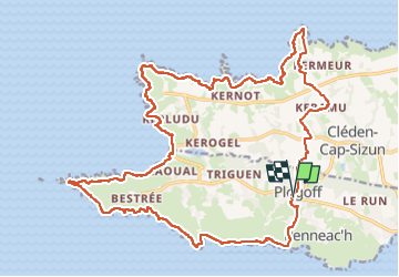
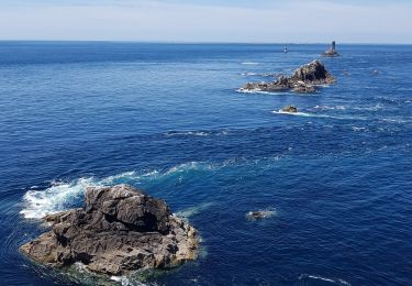
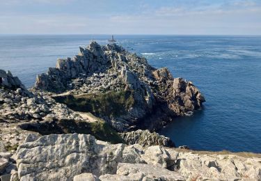
Randonnée Marche de 26 km à découvrir à Bretagne, Finistère, Plogoff. Cette randonnée est proposée par thonyc.
Description
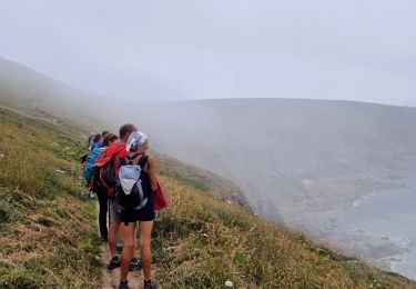
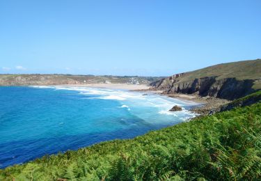
Randonnée de deux jours effectuée en février 2018. Magnifiques paysages de falaises escarpée et dentelée. Retour par des sentiers creux du cap Sizun.
Localisation
Pays :
France
Région :
Bretagne
Département/Province :
Finistère
Commune :
Plogoff
Localité :
Unknown
Départ:(Dec)
Départ:(UTM)
375698 ; 5321731 (30U) N.
Commentaires
Randonnées à proximité
![Randonnée Marche Cléden-Cap-Sizun - GR34 Pointe de Brézelec -- Cléden-Cap-Sizun (Pointe du Raz) - Photo](https://media.geolcdn.com/t/375/260/c8e4b333-f389-409b-a569-fa6f65a7aa66.jpg&format=jpg&maxdim=2)
![Marche Marche](https://static1.geolcdn.com/sitytour/trail-icons/101.png)
GR34 Pointe de Brézelec -- Cléden-Cap-Sizun (Pointe du Raz)
Marche
Très difficile
Cléden-Cap-Sizun,
Bretagne,
Finistère,
France
![](/images/other/stat-length.png)
23 km | 30 km-effort
6h 54min
![](https://static1.geolcdn.com/siteimages/upload/files/16400158638029165_repeat_loop_refresh_sync_direction_icon.png)
Non
![Randonnée Marche Plogoff - TREK RCY GR34 J4 2022 Pointe du Raz/ baie des trépassés - Photo](https://media.geolcdn.com/t/375/260/5d2c6731-b703-4e85-be24-5e5d9a1ced82.jpg&format=jpg&maxdim=2)
![Marche Marche](https://static1.geolcdn.com/sitytour/trail-icons/101.png)
TREK RCY GR34 J4 2022 Pointe du Raz/ baie des trépassés
Marche
Facile
Plogoff,
Bretagne,
Finistère,
France
![](/images/other/stat-length.png)
13,9 km | 18,3 km-effort
3h 42min
![](https://static1.geolcdn.com/siteimages/upload/files/16400158638029165_repeat_loop_refresh_sync_direction_icon.png)
Non
![Randonnée Marche Cléden-Cap-Sizun - Pointe du Van - Pointe du Raz par le GR34 - 13.5km 310m 4h10 (40mn) - 2019 09 04 - Photo](https://media.geolcdn.com/t/375/260/06129bcd-1428-4839-9879-17e65208fdf9.jpg&format=jpg&maxdim=2)
![Marche Marche](https://static1.geolcdn.com/sitytour/trail-icons/101.png)
Pointe du Van - Pointe du Raz par le GR34 - 13.5km 310m 4h10 (40mn) - 2019 09 04
Marche
Moyen
Cléden-Cap-Sizun,
Bretagne,
Finistère,
France
![](/images/other/stat-length.png)
13,5 km | 17,6 km-effort
4h 10min
![](https://static1.geolcdn.com/siteimages/upload/files/16400158638029165_repeat_loop_refresh_sync_direction_icon.png)
Oui
![Randonnée Marche Plogoff - la pointe du Raz - Photo](https://media.geolcdn.com/t/375/260/106b0dee-166f-4747-926b-7aeac04a59f3.jpg&format=jpg&maxdim=2)
![Marche Marche](https://static1.geolcdn.com/sitytour/trail-icons/101.png)
la pointe du Raz
Marche
Difficile
Plogoff,
Bretagne,
Finistère,
France
![](/images/other/stat-length.png)
5,3 km | 7 km-effort
2h 56min
![](https://static1.geolcdn.com/siteimages/upload/files/16400158638029165_repeat_loop_refresh_sync_direction_icon.png)
Oui
![Randonnée Marche Plogoff - plogoff loual - Photo](https://media.geolcdn.com/t/375/260/ext.jpg?maxdim=2&url=https%3A%2F%2Fstatic1.geolcdn.com%2Fsiteimages%2Fupload%2Ffiles%2F1553511878bg_sport_marche.png)
![Marche Marche](https://static1.geolcdn.com/sitytour/trail-icons/101.png)
plogoff loual
Marche
Facile
(1)
Plogoff,
Bretagne,
Finistère,
France
![](/images/other/stat-length.png)
4,1 km | 5 km-effort
1h 8min
![](https://static1.geolcdn.com/siteimages/upload/files/16400158638029165_repeat_loop_refresh_sync_direction_icon.png)
Oui
![Randonnée Marche Plogoff - la pointe du raz Bretagne - Photo](https://media.geolcdn.com/t/375/260/ext.jpg?maxdim=2&url=https%3A%2F%2Fstatic1.geolcdn.com%2Fsiteimages%2Fupload%2Ffiles%2F1553511878bg_sport_marche.png)
![Marche Marche](https://static1.geolcdn.com/sitytour/trail-icons/101.png)
la pointe du raz Bretagne
Marche
Très facile
(1)
Plogoff,
Bretagne,
Finistère,
France
![](/images/other/stat-length.png)
6,8 km | 9 km-effort
2h 19min
![](https://static1.geolcdn.com/siteimages/upload/files/16400158638029165_repeat_loop_refresh_sync_direction_icon.png)
Oui
![Randonnée Marche Cléden-Cap-Sizun - point du van - Photo](https://media.geolcdn.com/t/375/260/ext.jpg?maxdim=2&url=https%3A%2F%2Fstatic1.geolcdn.com%2Fsiteimages%2Fupload%2Ffiles%2F1553511878bg_sport_marche.png)
![Marche Marche](https://static1.geolcdn.com/sitytour/trail-icons/101.png)
point du van
Marche
Moyen
(1)
Cléden-Cap-Sizun,
Bretagne,
Finistère,
France
![](/images/other/stat-length.png)
10,6 km | 13,9 km-effort
Inconnu
![](https://static1.geolcdn.com/siteimages/upload/files/16400158638029165_repeat_loop_refresh_sync_direction_icon.png)
Oui
![Randonnée Marche Cléden-Cap-Sizun - Gr34 Cléden-Cap-Sizun -- Audierne - Photo](https://media.geolcdn.com/t/375/260/5b525b84-6ac9-4943-b831-b8f433338692.jpg&format=jpg&maxdim=2)
![Marche Marche](https://static1.geolcdn.com/sitytour/trail-icons/101.png)
Gr34 Cléden-Cap-Sizun -- Audierne
Marche
Très difficile
Cléden-Cap-Sizun,
Bretagne,
Finistère,
France
![](/images/other/stat-length.png)
21 km | 25 km-effort
5h 36min
![](https://static1.geolcdn.com/siteimages/upload/files/16400158638029165_repeat_loop_refresh_sync_direction_icon.png)
Non
![Randonnée Marche Cléden-Cap-Sizun - POINTE DU RAZ - Photo](https://media.geolcdn.com/t/375/260/50bf8e99-98ae-4340-8c1b-eb502686b93f.jpg&format=jpg&maxdim=2)
![Marche Marche](https://static1.geolcdn.com/sitytour/trail-icons/101.png)
POINTE DU RAZ
Marche
Facile
Cléden-Cap-Sizun,
Bretagne,
Finistère,
France
![](/images/other/stat-length.png)
15,7 km | 20 km-effort
4h 38min
![](https://static1.geolcdn.com/siteimages/upload/files/16400158638029165_repeat_loop_refresh_sync_direction_icon.png)
Oui