Randonnée Marche West Cork - Allihies - Castletownbere - Photo

Allihies - Castletownbere

 Geert H.
Geert H.

Utilisateur

© OpenStreetMap contributors
Longueur
Longueur
15,4 km
Altitude max
Altitude max
297 m
Dénivelé positif
Dénivelé positif
510 m
Km-Effort
Km-Effort  
22 km
Altitude min
Altitude min
4 m
Dénivelé négatif
Dénivelé négatif
556 m
Boucle
Boucle
Non
Date de création :
2024-08-18 08:53:33.259
Dernière modification :
2024-08-23 10:20:38.932

(0 Avis)

Marche
Marche
3h44
Difficulté : Difficile

Scannez ce code QR pour ouvrir la randonnée dans l'application SityTrail

Application GPS de randonnée GRATUITE

Logo SityTrail SityTrail

IGN / Instituts géographiques

Télécharger SityTrail sur l'App Store Télécharger SityTrail sur Google Play

Logo SityTrail SityTrail World

Le monde est à vous

Télécharger SityTrail sur l'App Store Télécharger SityTrail sur Google Play Télécharger SityTrail sur Huawei AppGallery

À propos

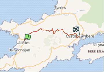
Randonnée Marche de 15,4 km à découvrir à Inconnu, County Cork, West Cork. Cette randonnée est proposée par Geert H..

Description

The abandoned copper mines of Allihies, where copper mining was carried out for centuries, are the
central theme of today's hike. Although mining ceased in the mid-19th century, it continues to dominate the area to this day.

Profil altimétrique

Photos

Points d'intérêt

Point d'intérêt West Cork - POI sans nom - Photo
Geert H.
WEST CORK 

Localisation

Pays :
Irlande
Région :
Inconnu
Département/Province :
County Cork
Commune :
West Cork
Localité :
Coulagh
Départ:(UTM)
427740 ; 5721587 (29U) N.

Randonnées à proximité

Randonnée Marche West Cork - Ballydonegan Loop Allihies - Photo
Marche
mlmoroneybb

Marche

Difficile
West Cork, Inconnu, County Cork, Irlande
17,9 km | 24 km-effort
Inconnu
Oui


Fermer
Mes abonnements