Randonnée A pied Maintenon - visite historique de Maintenon  - Photo

visite historique de Maintenon

 GOELERANDO2
GOELERANDO2

Utilisateur

© OpenStreetMap contributors
Longueur
Longueur
1,2 km
Altitude max
Altitude max
109 m
Dénivelé positif
Dénivelé positif
8 m
Km-Effort
Km-Effort  
1,3 km
Altitude min
Altitude min
101 m
Dénivelé négatif
Dénivelé négatif
3 m
Boucle
Boucle
Non
Date de création :
2024-08-14 13:54:27.876
Dernière modification :
2024-08-14 14:04:49.052

(0 Avis)

A pied
A pied
18m
Difficulté : Facile
Marche
Marche
18m
Difficulté : Facile

Scannez ce code QR pour ouvrir la randonnée dans l'application SityTrail

Application GPS de randonnée GRATUITE

Logo SityTrail SityTrail

IGN / Instituts géographiques

Télécharger SityTrail sur l'App Store Télécharger SityTrail sur Google Play

Logo SityTrail SityTrail World

Le monde est à vous

Télécharger SityTrail sur l'App Store Télécharger SityTrail sur Google Play Télécharger SityTrail sur Huawei AppGallery

À propos

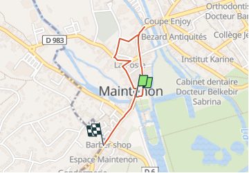
Randonnée A pied de 1,2 km à découvrir à Centre-Val de Loire, Eure-et-Loir, Maintenon. Cette randonnée est proposée par GOELERANDO2.

Description

suivre les balises historiques au départ du croisement des rues pierre Curie et  la rue  de Gallardon en directino du Château.

Profil altimétrique

Localisation

Pays :
France
Région :
Centre-Val de Loire
Département/Province :
Eure-et-Loir
Commune :
Maintenon
Localité :
Unknown
Départ:(UTM)
395106 ; 5382444 (31U) N.

Randonnées à proximité

Randonnée V.T.T. Maintenon - Bois et vallées - Maintenon - Photo
V.T.T.
tracegps

V.T.T.

Facile
(1)
Maintenon, Centre-Val de Loire, Eure-et-Loir, France
12,7 km | 14,7 km-effort
1h 0min
Oui
Randonnée Marche Saint-Piat - 20200611St Piat - Photo
Marche
Jeanclaudebic

Marche

Très facile
(1)
Saint-Piat, Centre-Val de Loire, Eure-et-Loir, France
10,6 km | 12,5 km-effort
2h 8min
Oui
Randonnée Marche Maintenon - maintenon - Photo
Marche
topophil

Marche

Très facile
(1)
Maintenon, Centre-Val de Loire, Eure-et-Loir, France
14 km | 16,3 km-effort
3h 5min
Oui
Randonnée Marche Maintenon - Bois et vallées - Maintenon - Photo
Marche
tracegps

Marche

Difficile
(3)
Maintenon, Centre-Val de Loire, Eure-et-Loir, France
12,7 km | 14,7 km-effort
3h 10min
Oui
Randonnée Marche Maintenon - Maintenon APL - Photo
Marche
jctbis

Marche

Moyen
Maintenon, Centre-Val de Loire, Eure-et-Loir, France
11,5 km | 12,8 km-effort
2h 38min
Oui
Randonnée sport Saint-Piat - Parcours Thierry, Geille Saint-Piat - Photo
sport
ezola

sport

Très facile
Saint-Piat, Centre-Val de Loire, Eure-et-Loir, France
23 km | 27 km-effort
Inconnu
Oui
Randonnée V.T.T. Hanches - hanches Droue sur Drouette st Hilarion - Photo
V.T.T.
topophil

V.T.T.

Difficile
Hanches, Centre-Val de Loire, Eure-et-Loir, France
31 km | 36 km-effort
3h 12min
Oui
Randonnée Marche nordique Saint-Piat - APL St Piat  - Photo
Marche nordique
jctbis

Marche nordique

Facile
Saint-Piat, Centre-Val de Loire, Eure-et-Loir, France
9,6 km | 11,5 km-effort
2h 1min
Oui
Randonnée Marche Maintenon - Maintenon Reco du 04 08 2022 - Photo
Marche
christianbossavy

Marche

Très facile
Maintenon, Centre-Val de Loire, Eure-et-Loir, France
8,1 km | 8,7 km-effort
2h 2min
Oui


Fermer
Mes abonnements