![](/images/other/stat-length.png)
![Randonnée Marche Samoëns - Refuge de la Golèse et refuge de Bostan en boucle - Photo](https://media.geolcdn.com/t/1900/400/ext.pjpeg?maxdim=2&url=https%3A%2F%2Fstatic1.geolcdn.com%2Fsiteimages%2Fupload%2Ffiles%2F1553511878bg_sport_marche.png)
Refuge de la Golèse et refuge de Bostan en boucle
Chabard
Utilisateur
![Longueur](/images/other/stat-length.png)
Longueur
11,7 km
![Altitude max](https://static1.geolcdn.com/siteimages/upload/files/1508320355ic_sort_altitude_max_24dp.png)
Altitude max
1864 m
![Dénivelé positif](https://static1.geolcdn.com/siteimages/upload/files/1508320355ic_sort_den_pos_24dp.png)
Dénivelé positif
788 m
![Km-Effort](/images/other/stat-length.png)
Km-Effort
22 km
![Altitude min](https://static1.geolcdn.com/siteimages/upload/files/1508320355ic_sort_altitude_min_24dp.png)
Altitude min
1111 m
![Dénivelé négatif](https://static1.geolcdn.com/siteimages/upload/files/1508320355ic_sort_den_neg_24dp.png)
Dénivelé négatif
783 m
![Boucle](https://static1.geolcdn.com/siteimages/upload/files/16400158638029165_repeat_loop_refresh_sync_direction_icon.png)
Boucle
Oui
Date de création :
2024-08-13 06:40:43.0
Dernière modification :
2024-08-13 17:22:43.59
![Marche](https://static1.geolcdn.com/sitytour/trail-icons/101.png)
5h01
Difficulté : Très difficile
![Scannez ce code QR pour ouvrir la randonnée dans l'application SityTrail](https://capi.geolives.com/qq0zvz2zws4bq2lad0pu/sitytour/trails/4154182/qr.png?size=200)
Application GPS de randonnée GRATUITE
À propos
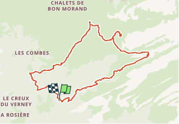
Randonnée Marche de 11,7 km à découvrir à Auvergne-Rhône-Alpes, Haute-Savoie, Samoëns. Cette randonnée est proposée par Chabard.
Description
Départ du parking des Allamands
Le Crêt Vosy
Les Chavonnes
La Batsaz
Col et refuge de Golèse
Les Lagots
Refuge de Bostan
Retour aux allamands
Localisation
Pays :
France
Région :
Auvergne-Rhône-Alpes
Département/Province :
Haute-Savoie
Commune :
Samoëns
Localité :
Unknown
Départ:(Dec)
Départ:(UTM)
326143 ; 5108988 (32T) N.
Commentaires
Randonnées à proximité
![Randonnée Marche Samoëns - Samoens . gorges des tines - retour - Photo](https://media.geolcdn.com/t/375/260/9ca94656-f570-41a8-90f6-cc5f5e98fa82.jpg&format=jpg&maxdim=2)
![Marche Marche](https://static1.geolcdn.com/sitytour/trail-icons/101.png)
Samoens . gorges des tines - retour
Marche
Très facile
Samoëns,
Auvergne-Rhône-Alpes,
Haute-Savoie,
France
![](/images/other/stat-length.png)
9,6 km | 12,9 km-effort
4h 1min
![](https://static1.geolcdn.com/siteimages/upload/files/16400158638029165_repeat_loop_refresh_sync_direction_icon.png)
Oui
![Randonnée Marche Samoëns - La Tête de Bostan - Photo](https://media.geolcdn.com/t/375/260/ext.jpg?maxdim=2&url=https%3A%2F%2Fstatic1.geolcdn.com%2Fsiteimages%2Fupload%2Ffiles%2F1553511878bg_sport_marche.png)
![Marche Marche](https://static1.geolcdn.com/sitytour/trail-icons/101.png)
La Tête de Bostan
Marche
Moyen
(2)
Samoëns,
Auvergne-Rhône-Alpes,
Haute-Savoie,
France
![](/images/other/stat-length.png)
14,9 km | 32 km-effort
6h 32min
![](https://static1.geolcdn.com/siteimages/upload/files/16400158638029165_repeat_loop_refresh_sync_direction_icon.png)
Oui
![Randonnée Ski de randonnée Samoëns - 2025-01-30 Sortie Ski de Rando Col de la Golese - Photo](https://media.geolcdn.com/t/375/260/5172d417-9875-43d9-89bb-031c8ee85781.jpg&format=jpg&maxdim=2)
![Ski de randonnée Ski de randonnée](https://static1.geolcdn.com/sitytour/trail-icons/503.png)
2025-01-30 Sortie Ski de Rando Col de la Golese
Ski de randonnée
Très facile
Samoëns,
Auvergne-Rhône-Alpes,
Haute-Savoie,
France
![](/images/other/stat-length.png)
8,5 km | 15,8 km-effort
Inconnu
![](https://static1.geolcdn.com/siteimages/upload/files/16400158638029165_repeat_loop_refresh_sync_direction_icon.png)
Oui
![Randonnée Marche Verchaix - col de joux plane - Photo](https://media.geolcdn.com/t/375/260/f5f22de2-b8d8-4ec7-857b-352656491634.jpg&format=jpg&maxdim=2)
![Marche Marche](https://static1.geolcdn.com/sitytour/trail-icons/101.png)
col de joux plane
Marche
Moyen
Verchaix,
Auvergne-Rhône-Alpes,
Haute-Savoie,
France
![](/images/other/stat-length.png)
10,5 km | 20 km-effort
6h 9min
![](https://static1.geolcdn.com/siteimages/upload/files/16400158638029165_repeat_loop_refresh_sync_direction_icon.png)
Oui
![Randonnée Marche Samoëns - La tête de Bostan - Photo](https://media.geolcdn.com/t/375/260/c42830f7-a262-4abd-8f00-d269896222b2.jpg&format=jpg&maxdim=2)
![Marche Marche](https://static1.geolcdn.com/sitytour/trail-icons/101.png)
La tête de Bostan
Marche
Très difficile
Samoëns,
Auvergne-Rhône-Alpes,
Haute-Savoie,
France
![](/images/other/stat-length.png)
15,7 km | 31 km-effort
5h 58min
![](https://static1.geolcdn.com/siteimages/upload/files/16400158638029165_repeat_loop_refresh_sync_direction_icon.png)
Oui
![Randonnée Marche Samoëns - SAMOENS: LES ALLAMANDS - BOSTAN (CHALETS - REFUGE - COL - TETE) - GOLESE - Photo](https://media.geolcdn.com/t/375/260/c5ba1cee-0408-4163-a2ab-ac65d7121802.jpg&format=jpg&maxdim=2)
![Marche Marche](https://static1.geolcdn.com/sitytour/trail-icons/101.png)
SAMOENS: LES ALLAMANDS - BOSTAN (CHALETS - REFUGE - COL - TETE) - GOLESE
Marche
Difficile
Samoëns,
Auvergne-Rhône-Alpes,
Haute-Savoie,
France
![](/images/other/stat-length.png)
17,3 km | 35 km-effort
6h 52min
![](https://static1.geolcdn.com/siteimages/upload/files/16400158638029165_repeat_loop_refresh_sync_direction_icon.png)
Oui
![Randonnée Marche Samoëns - les chalets du Bémont et cascade du Nant d Ant - Photo](https://media.geolcdn.com/t/375/260/70ac3ce4-77a9-4b40-b9e3-5a1ff6333052.jpg&format=jpg&maxdim=2)
![Marche Marche](https://static1.geolcdn.com/sitytour/trail-icons/101.png)
les chalets du Bémont et cascade du Nant d Ant
Marche
Moyen
Samoëns,
Auvergne-Rhône-Alpes,
Haute-Savoie,
France
![](/images/other/stat-length.png)
6,7 km | 10,5 km-effort
2h 10min
![](https://static1.geolcdn.com/siteimages/upload/files/16400158638029165_repeat_loop_refresh_sync_direction_icon.png)
Non
![Randonnée Marche Samoëns - SAMOENS: LAC DES CHAMBRES - Photo](https://media.geolcdn.com/t/375/260/cd8f3e5f-51d1-4c9a-9456-e0bd19938b89.jpg&format=jpg&maxdim=2)
![Marche Marche](https://static1.geolcdn.com/sitytour/trail-icons/101.png)
SAMOENS: LAC DES CHAMBRES
Marche
Difficile
Samoëns,
Auvergne-Rhône-Alpes,
Haute-Savoie,
France
![](/images/other/stat-length.png)
14,2 km | 31 km-effort
6h 11min
![](https://static1.geolcdn.com/siteimages/upload/files/16400158638029165_repeat_loop_refresh_sync_direction_icon.png)
Oui
![Randonnée Marche Samoëns - SAMOENS: BOSTAN - GOLESE - Photo](https://media.geolcdn.com/t/375/260/6d485ceb-76c9-494d-ab79-683ad7388c0a.jpg&format=jpg&maxdim=2)
![Marche Marche](https://static1.geolcdn.com/sitytour/trail-icons/101.png)
SAMOENS: BOSTAN - GOLESE
Marche
Difficile
Samoëns,
Auvergne-Rhône-Alpes,
Haute-Savoie,
France
![](/images/other/stat-length.png)
12,8 km | 24 km-effort
4h 51min
![](https://static1.geolcdn.com/siteimages/upload/files/16400158638029165_repeat_loop_refresh_sync_direction_icon.png)
Oui