![](/images/other/stat-length.png)
![Randonnée Marche Anhée - Marche Adeps à Anhée - Photo](https://media.geolcdn.com/t/1900/400/d1ccbdfc-5a69-4474-90f4-353194a0e2a1.jpg&format=pjpeg&maxdim=2)
Marche Adeps à Anhée
Desrumaux
Utilisateur GUIDE
![Longueur](/images/other/stat-length.png)
Longueur
9,6 km
![Altitude max](https://static1.geolcdn.com/siteimages/upload/files/1508320355ic_sort_altitude_max_24dp.png)
Altitude max
216 m
![Dénivelé positif](https://static1.geolcdn.com/siteimages/upload/files/1508320355ic_sort_den_pos_24dp.png)
Dénivelé positif
170 m
![Km-Effort](/images/other/stat-length.png)
Km-Effort
11,8 km
![Altitude min](https://static1.geolcdn.com/siteimages/upload/files/1508320355ic_sort_altitude_min_24dp.png)
Altitude min
84 m
![Dénivelé négatif](https://static1.geolcdn.com/siteimages/upload/files/1508320355ic_sort_den_neg_24dp.png)
Dénivelé négatif
170 m
![Boucle](https://static1.geolcdn.com/siteimages/upload/files/16400158638029165_repeat_loop_refresh_sync_direction_icon.png)
Boucle
Oui
Date de création :
2024-08-13 08:48:15.838
Dernière modification :
2024-08-13 09:21:17.441
![Marche](https://static1.geolcdn.com/sitytour/trail-icons/101.png)
2h41
Difficulté : Moyen
![Scannez ce code QR pour ouvrir la randonnée dans l'application SityTrail](https://capi.geolives.com/qq0zvz2zws4bq2lad0pu/sitytour/trails/4153751/qr.png?size=200)
Application GPS de randonnée GRATUITE
À propos
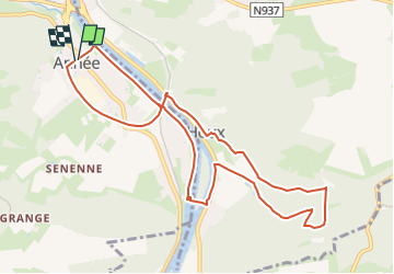
Randonnée Marche de 9,6 km à découvrir à Wallonie, Namur, Anhée. Cette randonnée est proposée par Desrumaux.
Description
Jolie balade en Val de Meuse inspirée de la marche Adeps de ce dimanche 11 aout organisée par le Royal Anhée Football Club mais avec le départ sur la place d'Anhée.
Bravo aux organisateurs.
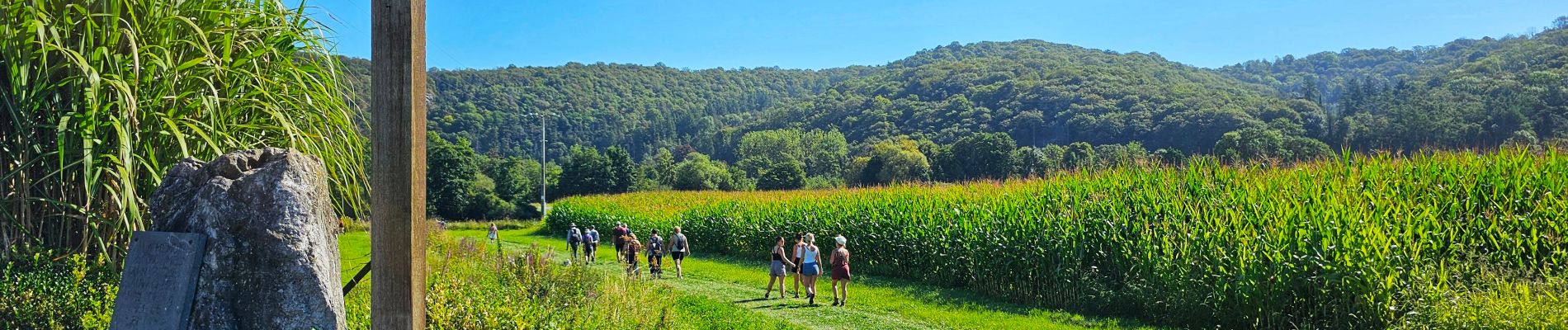
Localisation
Pays :
Belgique
Région :
Wallonie
Département/Province :
Namur
Commune :
Anhée
Localité :
Unknown
Départ:(Dec)
Départ:(UTM)
633708 ; 5574830 (31U) N.
Commentaires
Randonnées à proximité
![Marche Marche](https://static1.geolcdn.com/sitytour/trail-icons/101.png)
RB-Na-21_Mont
Marche
Très difficile
(6)
Yvoir,
Wallonie,
Namur,
Belgique
![](/images/other/stat-length.png)
22 km | 30 km-effort
6h 51min
![](https://static1.geolcdn.com/siteimages/upload/files/16400158638029165_repeat_loop_refresh_sync_direction_icon.png)
Oui
![Randonnée Marche Yvoir - RB-Na-03_Houx - Photo](https://media.geolcdn.com/t/375/260/ext.jpg?maxdim=2&url=https%3A%2F%2Fservices.sitytrail.com%2FGeolivesWS%2FDownloadMedia.ashx%3FTrailID%3D179628%26Media%3D8266bb1a-850d-41b8-8bad-8e0bd7c82bf9.jpg)
![Marche Marche](https://static1.geolcdn.com/sitytour/trail-icons/101.png)
RB-Na-03_Houx
Marche
Difficile
(11)
Yvoir,
Wallonie,
Namur,
Belgique
![](/images/other/stat-length.png)
22 km | 30 km-effort
7h 1min
![](https://static1.geolcdn.com/siteimages/upload/files/16400158638029165_repeat_loop_refresh_sync_direction_icon.png)
Oui
![Randonnée Marche Yvoir - RL-GG-38_Godinne_Dinant - Photo](https://media.geolcdn.com/t/375/260/4b7f8162-b405-4557-afe1-7567462c4aff.jpg&format=jpg&maxdim=2)
![Marche Marche](https://static1.geolcdn.com/sitytour/trail-icons/101.png)
RL-GG-38_Godinne_Dinant
Marche
Très difficile
(6)
Yvoir,
Wallonie,
Namur,
Belgique
![](/images/other/stat-length.png)
19,5 km | 27 km-effort
6h 13min
![](https://static1.geolcdn.com/siteimages/upload/files/16400158638029165_repeat_loop_refresh_sync_direction_icon.png)
Non
![Randonnée Marche Anhée - RF-Na-05 Annevoie, côté Jardins_Grande-boucle - Photo](https://media.geolcdn.com/t/375/260/ext.jpg?maxdim=2&url=https%3A%2F%2Fservices.sitytrail.com%2FGeolivesWS%2FDownloadMedia.ashx%3FTrailID%3D545753%26Media%3D5d973c83-4a6c-40fc-a026-25de6c754887.JPG)
![Marche Marche](https://static1.geolcdn.com/sitytour/trail-icons/101.png)
RF-Na-05 Annevoie, côté Jardins_Grande-boucle
Marche
Moyen
(11)
Anhée,
Wallonie,
Namur,
Belgique
![](/images/other/stat-length.png)
11,3 km | 14,5 km-effort
3h 6min
![](https://static1.geolcdn.com/siteimages/upload/files/16400158638029165_repeat_loop_refresh_sync_direction_icon.png)
Oui
![Randonnée Marche Anhée - RF-Na-05 Annevoie, côté Jardins_Petite-boucle - Photo](https://media.geolcdn.com/t/375/260/ext.jpg?maxdim=2&url=https%3A%2F%2Fservices.sitytrail.com%2FGeolivesWS%2FDownloadMedia.ashx%3FTrailID%3D545751%26Media%3D5d973c83-4a6c-40fc-a026-25de6c754887.JPG)
![Marche Marche](https://static1.geolcdn.com/sitytour/trail-icons/101.png)
RF-Na-05 Annevoie, côté Jardins_Petite-boucle
Marche
Facile
(7)
Anhée,
Wallonie,
Namur,
Belgique
![](/images/other/stat-length.png)
7,4 km | 10 km-effort
2h 7min
![](https://static1.geolcdn.com/siteimages/upload/files/16400158638029165_repeat_loop_refresh_sync_direction_icon.png)
Oui
![Marche Marche](https://static1.geolcdn.com/sitytour/trail-icons/101.png)
RB-Na-21_Mont_via-racc
Marche
Très difficile
(4)
Yvoir,
Wallonie,
Namur,
Belgique
![](/images/other/stat-length.png)
18,6 km | 25 km-effort
5h 43min
![](https://static1.geolcdn.com/siteimages/upload/files/16400158638029165_repeat_loop_refresh_sync_direction_icon.png)
Oui
![Randonnée Marche Yvoir - D'Yvoir à Evrehailles - Photo](https://media.geolcdn.com/t/375/260/ext.jpg?maxdim=2&url=https%3A%2F%2Fservices.sitytrail.com%2FGeolivesWS%2FDownloadMedia.ashx%3FTrailID%3D406377%26Media%3Ddbb536c7-63fc-4c6a-9524-770626f70bd4.JPG)
![Marche Marche](https://static1.geolcdn.com/sitytour/trail-icons/101.png)
D'Yvoir à Evrehailles
Marche
Facile
(2)
Yvoir,
Wallonie,
Namur,
Belgique
![](/images/other/stat-length.png)
9,9 km | 13,2 km-effort
2h 51min
![](https://static1.geolcdn.com/siteimages/upload/files/16400158638029165_repeat_loop_refresh_sync_direction_icon.png)
Oui
![Randonnée Marche Yvoir - De Godinne à Rivière par le point de vue des 7 Meuses - Photo](https://media.geolcdn.com/t/375/260/ext.jpg?maxdim=2&url=https%3A%2F%2Fservices.sitytrail.com%2FGeolivesWS%2FDownloadMedia.ashx%3FTrailID%3D374647%26Media%3D6a6b12ee-c73f-4592-aaf1-131be9d78f80.JPG)
![Marche Marche](https://static1.geolcdn.com/sitytour/trail-icons/101.png)
De Godinne à Rivière par le point de vue des 7 Meuses
Marche
Facile
(5)
Yvoir,
Wallonie,
Namur,
Belgique
![](/images/other/stat-length.png)
8,5 km | 11,6 km-effort
2h 30min
![](https://static1.geolcdn.com/siteimages/upload/files/16400158638029165_repeat_loop_refresh_sync_direction_icon.png)
Oui
![Randonnée Marche Dinant - Balade à Bouvignes - Photo](https://media.geolcdn.com/t/375/260/ext.jpg?maxdim=2&url=https%3A%2F%2Fservices.sitytrail.com%2FGeolivesWS%2FDownloadMedia.ashx%3FTrailID%3D223072%26Media%3D8dae2923-6a84-4680-856b-d65e95092209.JPG)
![Marche Marche](https://static1.geolcdn.com/sitytour/trail-icons/101.png)
Balade à Bouvignes
Marche
Facile
(3)
Dinant,
Wallonie,
Namur,
Belgique
![](/images/other/stat-length.png)
4,8 km | 7,2 km-effort
1h 34min
![](https://static1.geolcdn.com/siteimages/upload/files/16400158638029165_repeat_loop_refresh_sync_direction_icon.png)
Oui