![](/images/other/stat-length.png)
![Randonnée Marche Waldbillig - Müllerthal W7 par la déviation - Photo](https://media.geolcdn.com/t/1900/400/8d10e05b-8c1b-4794-a2ae-2af84a59d337.jpg&format=pjpeg&maxdim=2)
Müllerthal W7 par la déviation
mumu.larandonneuse
Utilisateur GUIDE
![Longueur](/images/other/stat-length.png)
![Altitude max](https://static1.geolcdn.com/siteimages/upload/files/1508320355ic_sort_altitude_max_24dp.png)
![Dénivelé positif](https://static1.geolcdn.com/siteimages/upload/files/1508320355ic_sort_den_pos_24dp.png)
![Km-Effort](/images/other/stat-length.png)
![Altitude min](https://static1.geolcdn.com/siteimages/upload/files/1508320355ic_sort_altitude_min_24dp.png)
![Dénivelé négatif](https://static1.geolcdn.com/siteimages/upload/files/1508320355ic_sort_den_neg_24dp.png)
![Boucle](https://static1.geolcdn.com/siteimages/upload/files/16400158638029165_repeat_loop_refresh_sync_direction_icon.png)
![Marche](https://static1.geolcdn.com/sitytour/trail-icons/101.png)
2h46
Difficulté : Moyen
![Scannez ce code QR pour ouvrir la randonnée dans l'application SityTrail](https://capi.geolives.com/qq0zvz2zws4bq2lad0pu/sitytour/trails/4153330/qr.png?size=200)
Application GPS de randonnée GRATUITE
À propos
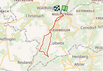
Randonnée Marche de 11,3 km à découvrir à Inconnu, Canton Echternach, Waldbillig. Cette randonnée est proposée par mumu.larandonneuse.
Description
Déviation en cours en 08/2024.
▪︎ Heringer Millen
Ce moulin superbement restauré du 17e siècle abrite un musée des moulins, une information touristique, une grande roue de moulin toujours en fonction et un ancien four en pierre de bois où le pain est fabriqué maison.
▪︎ Kalktuffquell
Au site de la source de tuffeau dans la vallée de l’Ernz Noire, l’eau calcaire très claire coule du rocher dans le petit bassin.
Le flamboiement des couleurs de l’eau et des roches ainsi que la diversité des mousses sont particulièrement impressionnants.
▪︎ Passage en bois d’une longueur de 600 m qui longe l’Ernz Noire
▪︎ La cascade du "Schiessentümpel", un lieu très photogénique du Müllerthal.
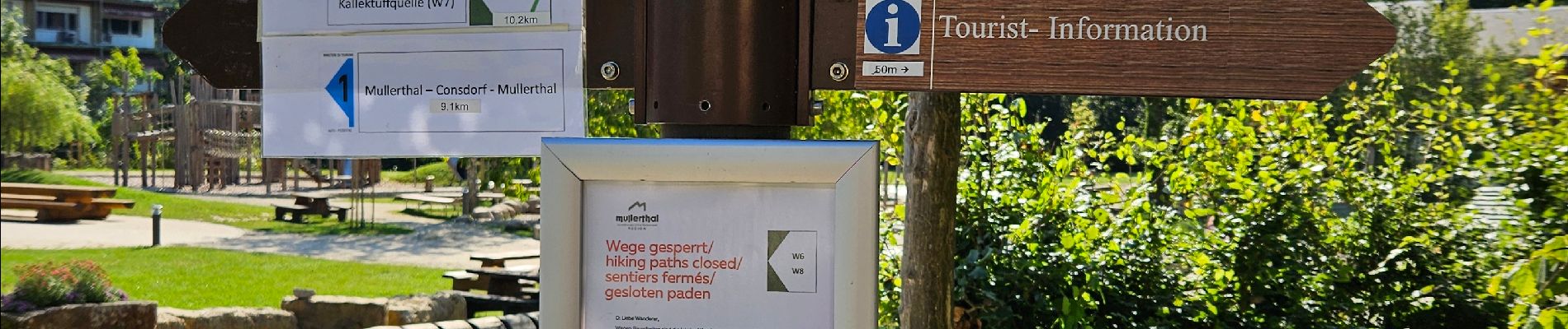
ℹ️ https://www.mullerthal-trail.lu/fr/fiche/walking/sentier-local-w7
Localisation
Commentaires
Randonnées à proximité
![Randonnée Marche Waldbillig - Haller - Sentier_local_-_W4 - Photo](https://media.geolcdn.com/t/375/260/d315698e-faa8-4cbd-932a-8a7221249730.jpg&format=jpg&maxdim=2)
![Marche Marche](https://static1.geolcdn.com/sitytour/trail-icons/101.png)
Marche
![](/images/other/stat-length.png)
![](https://static1.geolcdn.com/siteimages/upload/files/16400158638029165_repeat_loop_refresh_sync_direction_icon.png)
![Randonnée Marche Consdorf - Consdorf - C6 - Photo](https://media.geolcdn.com/t/375/260/1a93b691-9fc1-4ff8-ae1a-57fcf6e1418e.jpg&format=jpg&maxdim=2)
![Marche Marche](https://static1.geolcdn.com/sitytour/trail-icons/101.png)
Marche
![](/images/other/stat-length.png)
![](https://static1.geolcdn.com/siteimages/upload/files/16400158638029165_repeat_loop_refresh_sync_direction_icon.png)
![Randonnée Marche Consdorf - Consdorf - C2 (Müllerthal) - Photo](https://media.geolcdn.com/t/375/260/0cc79ac2-8683-4672-970a-cfe76e408507.jpg&format=jpg&maxdim=2)
![Marche Marche](https://static1.geolcdn.com/sitytour/trail-icons/101.png)
Marche
![](/images/other/stat-length.png)
![](https://static1.geolcdn.com/siteimages/upload/files/16400158638029165_repeat_loop_refresh_sync_direction_icon.png)
![Randonnée Marche Consdorf - Consdorf - Mullerthal - Photo](https://media.geolcdn.com/t/375/260/43e83e22-9e28-4a45-bf58-3588aa9e8a2f.jpg&format=jpg&maxdim=2)
![Marche Marche](https://static1.geolcdn.com/sitytour/trail-icons/101.png)
Marche
![](/images/other/stat-length.png)
![](https://static1.geolcdn.com/siteimages/upload/files/16400158638029165_repeat_loop_refresh_sync_direction_icon.png)
![Randonnée Marche Berdorf - Berdorf - B2 - Müllerthal - Photo](https://media.geolcdn.com/t/375/260/517daf86-eb8b-412e-9a7e-d0a346807e81.jpg&format=jpg&maxdim=2)
![Marche Marche](https://static1.geolcdn.com/sitytour/trail-icons/101.png)
Marche
![](/images/other/stat-length.png)
![](https://static1.geolcdn.com/siteimages/upload/files/16400158638029165_repeat_loop_refresh_sync_direction_icon.png)
![Randonnée Marche Beaufort - Beaufort - B1 - Photo](https://media.geolcdn.com/t/375/260/9b40ebf8-55f0-408d-8504-76ef1490c879.jpg&format=jpg&maxdim=2)
![Marche Marche](https://static1.geolcdn.com/sitytour/trail-icons/101.png)
Marche
![](/images/other/stat-length.png)
![](https://static1.geolcdn.com/siteimages/upload/files/16400158638029165_repeat_loop_refresh_sync_direction_icon.png)
![Randonnée Marche Waldbillig - Mullerthal randonnée magnifique - Photo](https://media.geolcdn.com/t/375/260/3f58fb00-23e0-4e5f-be44-94a05c44c601.jpg&format=jpg&maxdim=2)
![Marche Marche](https://static1.geolcdn.com/sitytour/trail-icons/101.png)
Marche
![](/images/other/stat-length.png)
![](https://static1.geolcdn.com/siteimages/upload/files/16400158638029165_repeat_loop_refresh_sync_direction_icon.png)
![Randonnée Marche Consdorf - Consdorf - Sentier local C1 - Photo](https://media.geolcdn.com/t/375/260/67bec963-192a-46c1-a89d-070dac0d9ebc.jpg&format=jpg&maxdim=2)
![Marche Marche](https://static1.geolcdn.com/sitytour/trail-icons/101.png)
Marche
![](/images/other/stat-length.png)
![](https://static1.geolcdn.com/siteimages/upload/files/16400158638029165_repeat_loop_refresh_sync_direction_icon.png)
![Randonnée Marche Berdorf - Berdorf - B8 - Müllerthal - Photo](https://media.geolcdn.com/t/375/260/7a8870ac-d558-4a39-b7c2-bdeb26e936c0.jpg&format=jpg&maxdim=2)
![Marche Marche](https://static1.geolcdn.com/sitytour/trail-icons/101.png)
Marche
![](/images/other/stat-length.png)
![](https://static1.geolcdn.com/siteimages/upload/files/16400158638029165_repeat_loop_refresh_sync_direction_icon.png)