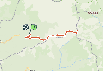
![](/images/other/stat-length.png)
![Randonnée Marche Guagno - I Pinzi Corbini - Photo](https://media.geolcdn.com/t/1900/400/dac2991b-5d9d-4554-8edc-bf67ed4dc007.jpg&format=pjpeg&maxdim=2)
I Pinzi Corbini
bozo1970
Utilisateur
![Longueur](/images/other/stat-length.png)
![Altitude max](https://static1.geolcdn.com/siteimages/upload/files/1508320355ic_sort_altitude_max_24dp.png)
![Dénivelé positif](https://static1.geolcdn.com/siteimages/upload/files/1508320355ic_sort_den_pos_24dp.png)
![Km-Effort](/images/other/stat-length.png)
![Altitude min](https://static1.geolcdn.com/siteimages/upload/files/1508320355ic_sort_altitude_min_24dp.png)
![Dénivelé négatif](https://static1.geolcdn.com/siteimages/upload/files/1508320355ic_sort_den_neg_24dp.png)
![Boucle](https://static1.geolcdn.com/siteimages/upload/files/16400158638029165_repeat_loop_refresh_sync_direction_icon.png)
![Marche](https://static1.geolcdn.com/sitytour/trail-icons/101.png)
9h05
Difficulté : Très difficile
![Scannez ce code QR pour ouvrir la randonnée dans l'application SityTrail](https://capi.geolives.com/qq0zvz2zws4bq2lad0pu/sitytour/trails/4153250/qr.png?size=200)
Application GPS de randonnée GRATUITE
À propos
Randonnée Marche de 17 km à découvrir à Corse, Corse-du-Sud, Guagno. Cette randonnée est proposée par bozo1970.
Description
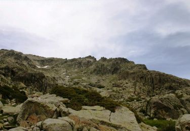
Départ des citernes DFCI Guagno 2 au bout de la piste (défoncée)
Montée par une ancienne piste forestière puis le sentier des bergeries de Baccialojo
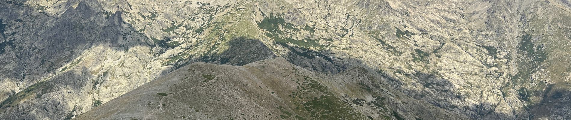
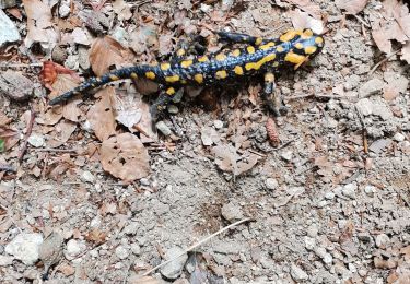
Petite via ferrata pour accéder au nid du Gypaète Barbu avec quelques anciennes carcasses
Quelques cairns ça et là, sentier très sale, aucun passage
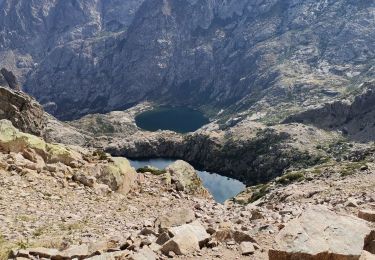
Sources de Giardine en 1h55’ 3km850 et D 550
Bocca Forca en 2h22’ 4km850 et D 750
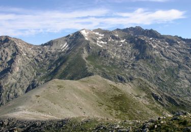
Bergeries de Baccialojo en3h 6km320 et D 800
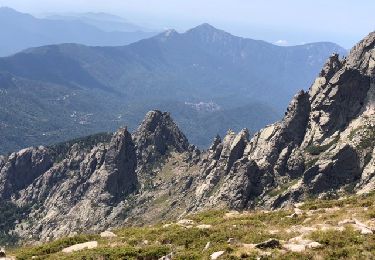
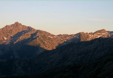
Sommet en 5h, 8km600 et D 946m
Chèvres, brebis, vaches et randonneurs sur la variante du GR 20
A/R en 9h05’ 17km700 et D 1150m
Localisation
Commentaires
Randonnées à proximité
![Randonnée Marche Venaco - Petra Piana Vizzavona - Photo](https://media.geolcdn.com/t/375/260/ee1ebeb9-649c-4232-ade0-293436696fb5.jpg&format=jpg&maxdim=2)
![Marche Marche](https://static1.geolcdn.com/sitytour/trail-icons/101.png)
Marche
![](/images/other/stat-length.png)
![](https://static1.geolcdn.com/siteimages/upload/files/16400158638029165_repeat_loop_refresh_sync_direction_icon.png)
![Randonnée Marche Venaco - GR20 Etape 8 Petra Piana Onda - Photo](https://media.geolcdn.com/t/375/260/6df182bf-90ab-4dfc-9e23-468bc3ea3254.jpg&format=jpg&maxdim=2)
![Marche Marche](https://static1.geolcdn.com/sitytour/trail-icons/101.png)
Marche
![](/images/other/stat-length.png)
![](https://static1.geolcdn.com/siteimages/upload/files/16400158638029165_repeat_loop_refresh_sync_direction_icon.png)
![Randonnée Marche Venaco - GR20 CORSE ÉTAPE 8 - Photo](https://media.geolcdn.com/t/375/260/7fa778c3-c157-4273-a3e6-32f6bc68aeba.jpg&format=jpg&maxdim=2)
![Marche Marche](https://static1.geolcdn.com/sitytour/trail-icons/101.png)
Marche
![](/images/other/stat-length.png)
![](https://static1.geolcdn.com/siteimages/upload/files/16400158638029165_repeat_loop_refresh_sync_direction_icon.png)
![Randonnée Marche Orto - GR20 Corse étape 7 - Photo](https://media.geolcdn.com/t/375/260/e392c43d-f359-40e7-8ed2-e2de79c97eaf.jpg&format=jpg&maxdim=2)
![Marche Marche](https://static1.geolcdn.com/sitytour/trail-icons/101.png)
Marche
![](/images/other/stat-length.png)
![](https://static1.geolcdn.com/siteimages/upload/files/16400158638029165_repeat_loop_refresh_sync_direction_icon.png)
![Randonnée Marche Guagno - À Soglia - Photo](https://media.geolcdn.com/t/375/260/67d365a2-9731-43fc-be2a-548459b265e0.jpeg&format=jpg&maxdim=2)
![Marche Marche](https://static1.geolcdn.com/sitytour/trail-icons/101.png)
Marche
![](/images/other/stat-length.png)
![](https://static1.geolcdn.com/siteimages/upload/files/16400158638029165_repeat_loop_refresh_sync_direction_icon.png)
![Randonnée Marche Venaco - GR 20® du refuge de Petra Piana au refuge de L'Onda par les crêtes - Photo](https://media.geolcdn.com/t/375/260/ext.jpg?maxdim=2&url=https%3A%2F%2Fservices.sitytrail.com%2FGeolivesWS%2FDownloadMedia.ashx%3FTrailID%3D316733%26Media%3D4647_1.jpg)
![Marche Marche](https://static1.geolcdn.com/sitytour/trail-icons/101.png)
Marche
![](/images/other/stat-length.png)
![](https://static1.geolcdn.com/siteimages/upload/files/16400158638029165_repeat_loop_refresh_sync_direction_icon.png)
![Randonnée Marche Venaco - GR 20® du refuge de Petra Piana au refuge de L'Onda - Photo](https://media.geolcdn.com/t/375/260/ext.jpg?maxdim=2&url=https%3A%2F%2Fservices.sitytrail.com%2FGeolivesWS%2FDownloadMedia.ashx%3FTrailID%3D316732%26Media%3D4646_1.jpg)
![Marche Marche](https://static1.geolcdn.com/sitytour/trail-icons/101.png)
Marche
![](/images/other/stat-length.png)
![](https://static1.geolcdn.com/siteimages/upload/files/16400158638029165_repeat_loop_refresh_sync_direction_icon.png)
![Randonnée Marche Venaco - GR 20® Laison du refuge de Petra Piana à Guagnu - Photo](https://media.geolcdn.com/t/375/260/ext.jpg?maxdim=2&url=https%3A%2F%2Fservices.sitytrail.com%2FGeolivesWS%2FDownloadMedia.ashx%3FTrailID%3D316731%26Media%3D4645_1.jpg)
![Marche Marche](https://static1.geolcdn.com/sitytour/trail-icons/101.png)
Marche
![](/images/other/stat-length.png)
![](https://static1.geolcdn.com/siteimages/upload/files/16400158638029165_repeat_loop_refresh_sync_direction_icon.png)
![Randonnée Marche Orto - Lac de creno - Photo](https://media.geolcdn.com/t/375/260/ext.jpg?maxdim=2&url=https%3A%2F%2Fstatic1.geolcdn.com%2Fsiteimages%2Fupload%2Ffiles%2F1553511878bg_sport_marche.png)
![Marche Marche](https://static1.geolcdn.com/sitytour/trail-icons/101.png)