Randonnée Marche Waldbillig - Haller - Sentier_local_-_W4 - Photo

Haller - Sentier_local_-_W4

 mumu.larandonneuse
mumu.larandonneuse

Utilisateur GUIDE

© OpenStreetMap contributors
Longueur
Longueur
6,2 km
Altitude max
Altitude max
366 m
Dénivelé positif
Dénivelé positif
117 m
Km-Effort
Km-Effort  
7,8 km
Altitude min
Altitude min
273 m
Dénivelé négatif
Dénivelé négatif
117 m
Boucle
Boucle
Oui
Date de création :
2024-08-10 13:10:00.606
Dernière modification :
2024-08-11 14:03:23.34

(1 Avis)

Marche
Marche
1h45
Difficulté : Moyen

Scannez ce code QR pour ouvrir la randonnée dans l'application SityTrail

Application GPS de randonnée GRATUITE

Logo SityTrail SityTrail

IGN / Instituts géographiques

Télécharger SityTrail sur l'App Store Télécharger SityTrail sur Google Play

Logo SityTrail SityTrail World

Le monde est à vous

Télécharger SityTrail sur l'App Store Télécharger SityTrail sur Google Play Télécharger SityTrail sur Huawei AppGallery

À propos

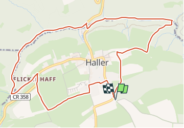
Randonnée Marche de 6,2 km à découvrir à Inconnu, Canton Echternach, Waldbillig. Cette randonnée est proposée par mumu.larandonneuse.

Description

Sentier varié offrant forêts, rochers, eau et champs, adapté aux familles.

Cette belle randonnée de presque 6 km prend son départ dans le pittoresque village de Haller. Sur des sentiers faciles, cette randonnée offre un mélange de rochers et de prés. Tout d'abord, le chemin serpente à travers la vallée sauvage et romantique de Hallerbach et passe devant l'ancien moulin. Vous longez ensuite des formations rocheuses impressionnantes  telles que "Ellerlee".

Le chemin du retour passe à côté de champs et prairies, puis par le centre du village pour revenir au point de départ.

Le circuit convient aux familles, mais n'est pas adapté aux poussettes.

ℹ️ https://www.mullerthal-trail.lu/fr/fiche/walking/sentier-local-w4
.

Profil altimétrique

Photos

Localisation

Pays :
Luxembourg
Région :
Inconnu
Département/Province :
Canton Echternach
Commune :
Waldbillig
Localité :
Unknown
Départ:(UTM)
304758 ; 5521668 (32U) N.

Commentaires

Veuillez vous connecter pour laisser un commentaire ou une note


Magnifique balade, facile pour les familles.


Randonnées à proximité

Randonnée Marche Consdorf - Consdorf - C6 - Photo
Marche
GUIDE
mumu.larandonneuse

Marche

Moyen
(1)
Consdorf, Inconnu, Canton Echternach, Luxembourg
5,8 km | 7,3 km-effort
1h 39min
Oui
Randonnée Marche Consdorf - Consdorf - C2 (Müllerthal) - Photo
Marche
GUIDE
mumu.larandonneuse

Marche

Facile
(1)
Consdorf, Inconnu, Canton Echternach, Luxembourg
4,2 km | 5,5 km-effort
1h 15min
Oui
Randonnée Marche Consdorf - Consdorf - Mullerthal - Photo
Marche
GUIDE
mumu.larandonneuse

Marche

Moyen
(2)
Consdorf, Inconnu, Canton Echternach, Luxembourg
9 km | 12,3 km-effort
2h 48min
Oui
Randonnée Marche Berdorf - Berdorf - B2 - Müllerthal - Photo
Marche
GUIDE
mumu.larandonneuse

Marche

Moyen
(2)
Berdorf, Inconnu, Canton Echternach, Luxembourg
6,7 km | 8,5 km-effort
1h 35min
Oui
Randonnée Marche Beaufort - Beaufort - B1 - Photo
Marche
GUIDE
mumu.larandonneuse

Marche

Moyen
(1)
Beaufort, Inconnu, Canton Echternach, Luxembourg
10,6 km | 13,6 km-effort
3h 5min
Oui
Randonnée Marche Beaufort - Mullerthal - Extra Tour B - Photo
Marche
GUIDE
mumu.larandonneuse

Marche

Moyen
(2)
Beaufort, Inconnu, Canton Echternach, Luxembourg
12,9 km | 16,8 km-effort
3h 48min
Oui
Randonnée Marche Consdorf - Consdorf - Sentier local C1  - Photo
Marche
GUIDE
mumu.larandonneuse

Marche

Facile
(1)
Consdorf, Inconnu, Canton Echternach, Luxembourg
1,9 km | 2,5 km-effort
34min
Oui
Randonnée Marche Berdorf - Berdorf - B8 - Müllerthal - Photo
Marche
GUIDE
mumu.larandonneuse

Marche

Moyen
(2)
Berdorf, Inconnu, Canton Echternach, Luxembourg
11,7 km | 15 km-effort
3h 24min
Oui
Randonnée Marche Waldbillig - Mullerthal randonnée magnifique - Photo
Marche
Alfredy

Marche

Difficile
(4)
Waldbillig, Inconnu, Canton Echternach, Luxembourg
9,3 km | 12,9 km-effort
4h 21min
Oui


Fermer
Mes abonnements