![](/images/other/stat-length.png)
![Randonnée Marche Locmaria - Locmaria - Photo](https://media.geolcdn.com/t/1900/400/ext.pjpeg?maxdim=2&url=https%3A%2F%2Fstatic1.geolcdn.com%2Fsiteimages%2Fupload%2Ffiles%2F1553511878bg_sport_marche.png)
Locmaria
benoitrando
Utilisateur
![Longueur](/images/other/stat-length.png)
Longueur
2,2 km
![Altitude max](https://static1.geolcdn.com/siteimages/upload/files/1508320355ic_sort_altitude_max_24dp.png)
Altitude max
56 m
![Dénivelé positif](https://static1.geolcdn.com/siteimages/upload/files/1508320355ic_sort_den_pos_24dp.png)
Dénivelé positif
64 m
![Km-Effort](/images/other/stat-length.png)
Km-Effort
3 km
![Altitude min](https://static1.geolcdn.com/siteimages/upload/files/1508320355ic_sort_altitude_min_24dp.png)
Altitude min
11 m
![Dénivelé négatif](https://static1.geolcdn.com/siteimages/upload/files/1508320355ic_sort_den_neg_24dp.png)
Dénivelé négatif
27 m
![Boucle](https://static1.geolcdn.com/siteimages/upload/files/16400158638029165_repeat_loop_refresh_sync_direction_icon.png)
Boucle
Non
Date de création :
2024-08-07 08:19:07.706
Dernière modification :
2024-08-07 09:06:04.451
![Marche](https://static1.geolcdn.com/sitytour/trail-icons/101.png)
36m
Difficulté : Difficile
![Scannez ce code QR pour ouvrir la randonnée dans l'application SityTrail](https://capi.geolives.com/qq0zvz2zws4bq2lad0pu/sitytour/trails/4147317/qr.png?size=200)
Application GPS de randonnée GRATUITE
À propos
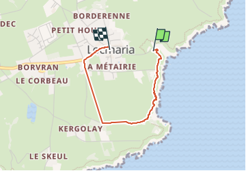
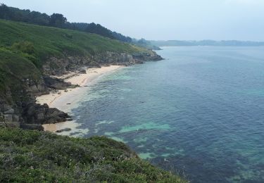
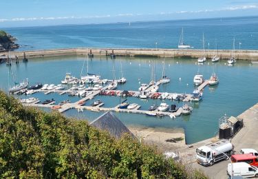
Randonnée Marche de 2,2 km à découvrir à Bretagne, Morbihan, Locmaria. Cette randonnée est proposée par benoitrando.
Description
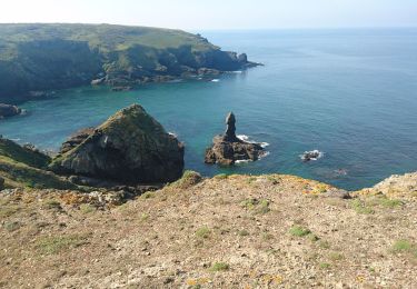
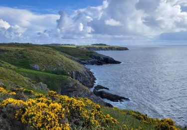
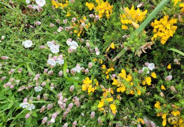
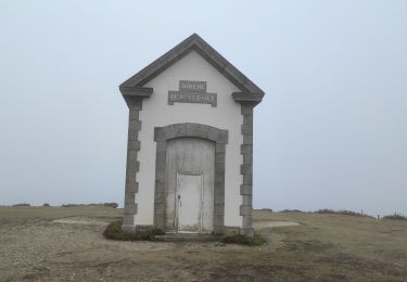
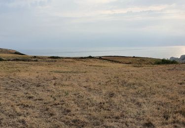
le sentier cotier est difficile il monte et descends de manière assez directe. Bien à echauffer chevilles et genoux. Parcouru avec des chaussures bateau sans difficultés mais lentement.... très bon pour s entraîner au trail
Localisation
Pays :
France
Région :
Bretagne
Département/Province :
Morbihan
Commune :
Locmaria
Localité :
Unknown
Départ:(Dec)
Départ:(UTM)
494182 ; 5237825 (30T) N.
Commentaires
Randonnées à proximité
![Randonnée Marche Locmaria - 4-Locmaria - Le Palais à Belle Île en mer - Photo](https://media.geolcdn.com/t/375/260/5b5376cc-5057-4f4d-b255-68cd89349ca0.jpg&format=jpg&maxdim=2)
![Marche Marche](https://static1.geolcdn.com/sitytour/trail-icons/101.png)
4-Locmaria - Le Palais à Belle Île en mer
Marche
Facile
Locmaria,
Bretagne,
Morbihan,
France
![](/images/other/stat-length.png)
16,7 km | 22 km-effort
3h 30min
![](https://static1.geolcdn.com/siteimages/upload/files/16400158638029165_repeat_loop_refresh_sync_direction_icon.png)
Non
![Randonnée Marche Locmaria - Belle-Île lokmaria 2019 - Photo](https://media.geolcdn.com/t/375/260/f2d42b8a-e839-468c-b303-bc39b2703316.jpg&format=jpg&maxdim=2)
![Marche Marche](https://static1.geolcdn.com/sitytour/trail-icons/101.png)
Belle-Île lokmaria 2019
Marche
Facile
Locmaria,
Bretagne,
Morbihan,
France
![](/images/other/stat-length.png)
12,4 km | 15,8 km-effort
4h 44min
![](https://static1.geolcdn.com/siteimages/upload/files/16400158638029165_repeat_loop_refresh_sync_direction_icon.png)
Non
![Randonnée Autre activité Locmaria - pointe du skeul - Photo](https://media.geolcdn.com/t/375/260/ext.jpg?maxdim=2&url=https%3A%2F%2Fstatic1.geolcdn.com%2Fsiteimages%2Fupload%2Ffiles%2F1545311037marcheuse_200dpi.jpg)
![Autre activité Autre activité](https://static1.geolcdn.com/sitytour/trail-icons/900.png)
pointe du skeul
Autre activité
Moyen
(1)
Locmaria,
Bretagne,
Morbihan,
France
![](/images/other/stat-length.png)
4,7 km | 5,8 km-effort
1h 15min
![](https://static1.geolcdn.com/siteimages/upload/files/16400158638029165_repeat_loop_refresh_sync_direction_icon.png)
Oui
![Randonnée Marche Locmaria - Locmaria - Le Palais 18 km - Photo](https://media.geolcdn.com/t/375/260/f6cfcf95-8530-45dc-b194-c5252bea21e1.jpg&format=jpg&maxdim=2)
![Marche Marche](https://static1.geolcdn.com/sitytour/trail-icons/101.png)
Locmaria - Le Palais 18 km
Marche
Très difficile
Locmaria,
Bretagne,
Morbihan,
France
![](/images/other/stat-length.png)
17,7 km | 22 km-effort
5h 11min
![](https://static1.geolcdn.com/siteimages/upload/files/16400158638029165_repeat_loop_refresh_sync_direction_icon.png)
Non
![Randonnée Marche Locmaria - Locmaria à Le Palais - Photo](https://media.geolcdn.com/t/375/260/b901e575-0542-4297-a70f-1b5407ca713b.jpg&format=jpg&maxdim=2)
![Marche Marche](https://static1.geolcdn.com/sitytour/trail-icons/101.png)
Locmaria à Le Palais
Marche
Moyen
Locmaria,
Bretagne,
Morbihan,
France
![](/images/other/stat-length.png)
15,5 km | 19,3 km-effort
1h 59min
![](https://static1.geolcdn.com/siteimages/upload/files/16400158638029165_repeat_loop_refresh_sync_direction_icon.png)
Non
![Randonnée Marche Locmaria - GR 340 - 4ème étape Le Grand Cosquet - Port Coton - Photo](https://media.geolcdn.com/t/375/260/42e305e8-9fa5-4467-86a2-4f422a00ba42.jpg&format=jpg&maxdim=2)
![Marche Marche](https://static1.geolcdn.com/sitytour/trail-icons/101.png)
GR 340 - 4ème étape Le Grand Cosquet - Port Coton
Marche
Difficile
Locmaria,
Bretagne,
Morbihan,
France
![](/images/other/stat-length.png)
17,8 km | 22 km-effort
5h 16min
![](https://static1.geolcdn.com/siteimages/upload/files/16400158638029165_repeat_loop_refresh_sync_direction_icon.png)
Non
![Randonnée Marche Locmaria - de la croix rouge au Skeul en passant par Keroulep - Photo](https://media.geolcdn.com/t/375/260/5992c98a-ee74-4a97-a537-9c64cd9723cf.jpg&format=jpg&maxdim=2)
![Marche Marche](https://static1.geolcdn.com/sitytour/trail-icons/101.png)
de la croix rouge au Skeul en passant par Keroulep
Marche
Très facile
Locmaria,
Bretagne,
Morbihan,
France
![](/images/other/stat-length.png)
6,3 km | 7,1 km-effort
1h 34min
![](https://static1.geolcdn.com/siteimages/upload/files/16400158638029165_repeat_loop_refresh_sync_direction_icon.png)
Oui
![Randonnée Marche Locmaria - GR340 BELLE-ILE Jour 4 de Locmaria retour Le Palais - Photo](https://media.geolcdn.com/t/375/260/69be104d-cf12-4de1-b15d-828ebd641573.jpg&format=jpg&maxdim=2)
![Marche Marche](https://static1.geolcdn.com/sitytour/trail-icons/101.png)
GR340 BELLE-ILE Jour 4 de Locmaria retour Le Palais
Marche
Difficile
Locmaria,
Bretagne,
Morbihan,
France
![](/images/other/stat-length.png)
16 km | 21 km-effort
3h 36min
![](https://static1.geolcdn.com/siteimages/upload/files/16400158638029165_repeat_loop_refresh_sync_direction_icon.png)
Non
![Randonnée Marche Locmaria - Locmaria Le palais 19 mai 2022 CA - Photo](https://media.geolcdn.com/t/375/260/fafe45df-7292-48a1-a84a-0100f2cd33b3.jpg&format=jpg&maxdim=2)
![Marche Marche](https://static1.geolcdn.com/sitytour/trail-icons/101.png)
Locmaria Le palais 19 mai 2022 CA
Marche
Très difficile
Locmaria,
Bretagne,
Morbihan,
France
![](/images/other/stat-length.png)
19,3 km | 24 km-effort
4h 58min
![](https://static1.geolcdn.com/siteimages/upload/files/16400158638029165_repeat_loop_refresh_sync_direction_icon.png)
Non