![](/images/other/stat-length.png)
![Randonnée V.T.T. Lourmarin - Lourmarin -Mourre Negre- Auribeau- AiguëBrun - Photo](https://media.geolcdn.com/t/1900/400/ext.pjpeg?maxdim=2&url=https%3A%2F%2Fstatic1.geolcdn.com%2Fsiteimages%2Fupload%2Ffiles%2F1524743154velo.jpg)
Lourmarin -Mourre Negre- Auribeau- AiguëBrun
DG01
Utilisateur
![Longueur](/images/other/stat-length.png)
![Altitude max](https://static1.geolcdn.com/siteimages/upload/files/1508320355ic_sort_altitude_max_24dp.png)
![Dénivelé positif](https://static1.geolcdn.com/siteimages/upload/files/1508320355ic_sort_den_pos_24dp.png)
![Km-Effort](/images/other/stat-length.png)
![Altitude min](https://static1.geolcdn.com/siteimages/upload/files/1508320355ic_sort_altitude_min_24dp.png)
![Dénivelé négatif](https://static1.geolcdn.com/siteimages/upload/files/1508320355ic_sort_den_neg_24dp.png)
![Boucle](https://static1.geolcdn.com/siteimages/upload/files/16400158638029165_repeat_loop_refresh_sync_direction_icon.png)
![V.T.T.](https://static1.geolcdn.com/sitytour/trail-icons/202.png)
4h12
Difficulté : Très difficile
![Scannez ce code QR pour ouvrir la randonnée dans l'application SityTrail](https://capi.geolives.com/qq0zvz2zws4bq2lad0pu/sitytour/trails/4145094/qr.png?size=200)
Application GPS de randonnée GRATUITE
À propos
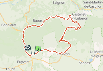
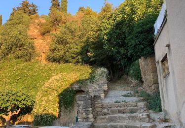
Randonnée V.T.T. de 44 km à découvrir à Provence-Alpes-Côte d'Azur, Vaucluse, Lourmarin. Cette randonnée est proposée par DG01.
Description
Depuis Cucuron, monter le DFCI (1h30 environ) jusqu’au Mourre Negre, puis descendre le chemin de Marauviere (début quelconque, mais devient ensuite un super single (2-3 passages à pied) jusqu’à Auribeau).
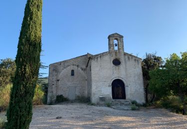
Remonter légèrement jusqu’à la chapelle pour ensuite descendre le long de L’Aigue Brun (magnifique single, mais attention aux randonneurs).
En résumé, tour absolument magnifique pour la beauté des paysages, les singles de qualité, mais exigeant.
Localisation
Commentaires
Randonnées à proximité
![Randonnée Marche Vaugines - PF-Vaugines - Cucuron - l'Ermitage - Vaugines - 17.06.2021 - Photo](https://media.geolcdn.com/t/375/260/49a6fcb0-e7e8-4e10-aa10-ef2270b11aa9.jpg&format=jpg&maxdim=2)
![Marche Marche](https://static1.geolcdn.com/sitytour/trail-icons/101.png)
Marche
![](/images/other/stat-length.png)
![](https://static1.geolcdn.com/siteimages/upload/files/16400158638029165_repeat_loop_refresh_sync_direction_icon.png)
![Randonnée Marche Cadenet - Cadenet -Lourmarin - Photo](https://media.geolcdn.com/t/375/260/f0fee848-9372-4ead-90a1-4f47846561d2.jpg&format=jpg&maxdim=2)
![Marche Marche](https://static1.geolcdn.com/sitytour/trail-icons/101.png)
Marche
![](/images/other/stat-length.png)
![](https://static1.geolcdn.com/siteimages/upload/files/16400158638029165_repeat_loop_refresh_sync_direction_icon.png)
![Marche Marche](https://static1.geolcdn.com/sitytour/trail-icons/101.png)
Marche
![](/images/other/stat-length.png)
![](https://static1.geolcdn.com/siteimages/upload/files/16400158638029165_repeat_loop_refresh_sync_direction_icon.png)
![Randonnée Marche Cadenet - PF-Cadenet - De Cadenet à Lourmarin - 3 - Photo](https://media.geolcdn.com/t/375/260/a6ee6e4b-3e12-4299-848e-3348098a84d0.jpg&format=jpg&maxdim=2)
![Marche Marche](https://static1.geolcdn.com/sitytour/trail-icons/101.png)
Marche
![](/images/other/stat-length.png)
![](https://static1.geolcdn.com/siteimages/upload/files/16400158638029165_repeat_loop_refresh_sync_direction_icon.png)
![Marche Marche](https://static1.geolcdn.com/sitytour/trail-icons/101.png)
Marche
![](/images/other/stat-length.png)
![](https://static1.geolcdn.com/siteimages/upload/files/16400158638029165_repeat_loop_refresh_sync_direction_icon.png)
![Randonnée Marche Vaugines - Vaugines - roque rousse. - Vaugines - Photo](https://media.geolcdn.com/t/375/260/6177de4a-3309-4104-9e1d-30cfd59fb2bd.jpg&format=jpg&maxdim=2)
![Marche Marche](https://static1.geolcdn.com/sitytour/trail-icons/101.png)
Marche
![](/images/other/stat-length.png)
![](https://static1.geolcdn.com/siteimages/upload/files/16400158638029165_repeat_loop_refresh_sync_direction_icon.png)
![Randonnée A pied Lourmarin - Lourmarin - Cadenet - Lourmarin - Photo](https://media.geolcdn.com/t/375/260/2d53adfc-3504-4117-a8f3-d2bec3eead0d.jpg&format=jpg&maxdim=2)
![A pied A pied](https://static1.geolcdn.com/sitytour/trail-icons/100.png)
A pied
![](/images/other/stat-length.png)
![](https://static1.geolcdn.com/siteimages/upload/files/16400158638029165_repeat_loop_refresh_sync_direction_icon.png)
![Randonnée Marche Vaugines - Luberon Vaugines Cucuron - Photo](https://media.geolcdn.com/t/375/260/6272fad2-dba5-4d24-99de-fd6c5316cc92.jpg&format=jpg&maxdim=2)
![Marche Marche](https://static1.geolcdn.com/sitytour/trail-icons/101.png)
Marche
![](/images/other/stat-length.png)
![](https://static1.geolcdn.com/siteimages/upload/files/16400158638029165_repeat_loop_refresh_sync_direction_icon.png)
![Randonnée Marche Cadenet - Cadenet Lourmarin Cadenet - Photo](https://media.geolcdn.com/t/375/260/9ae9fb37-52f2-488e-8d20-dd9900ea5cda.jpg&format=jpg&maxdim=2)
![Marche Marche](https://static1.geolcdn.com/sitytour/trail-icons/101.png)
Marche
![](/images/other/stat-length.png)
![](https://static1.geolcdn.com/siteimages/upload/files/16400158638029165_repeat_loop_refresh_sync_direction_icon.png)