![](/images/other/stat-length.png)
![Randonnée Marche Saint-Diéry - Horizons 2024 : Green Washing - Saint-Diéry - Photo](https://media.geolcdn.com/t/1900/400/f6f05842-27df-4b40-a6c4-fdecffc5a837.jpg&format=pjpeg&maxdim=2)
Horizons 2024 : Green Washing - Saint-Diéry
jagarnier
Utilisateur GUIDE
![Longueur](/images/other/stat-length.png)
![Altitude max](https://static1.geolcdn.com/siteimages/upload/files/1508320355ic_sort_altitude_max_24dp.png)
![Dénivelé positif](https://static1.geolcdn.com/siteimages/upload/files/1508320355ic_sort_den_pos_24dp.png)
![Km-Effort](/images/other/stat-length.png)
![Altitude min](https://static1.geolcdn.com/siteimages/upload/files/1508320355ic_sort_altitude_min_24dp.png)
![Dénivelé négatif](https://static1.geolcdn.com/siteimages/upload/files/1508320355ic_sort_den_neg_24dp.png)
![Boucle](https://static1.geolcdn.com/siteimages/upload/files/16400158638029165_repeat_loop_refresh_sync_direction_icon.png)
![Marche](https://static1.geolcdn.com/sitytour/trail-icons/101.png)
16m
Difficulté : Facile
![Scannez ce code QR pour ouvrir la randonnée dans l'application SityTrail](https://capi.geolives.com/qq0zvz2zws4bq2lad0pu/sitytour/trails/4144857/qr.png?size=200)
Application GPS de randonnée GRATUITE
À propos
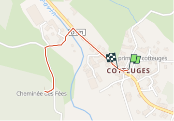
Randonnée Marche de 1,1 km à découvrir à Auvergne-Rhône-Alpes, Puy-de-Dôme, Saint-Diéry. Cette randonnée est proposée par jagarnier.
Description
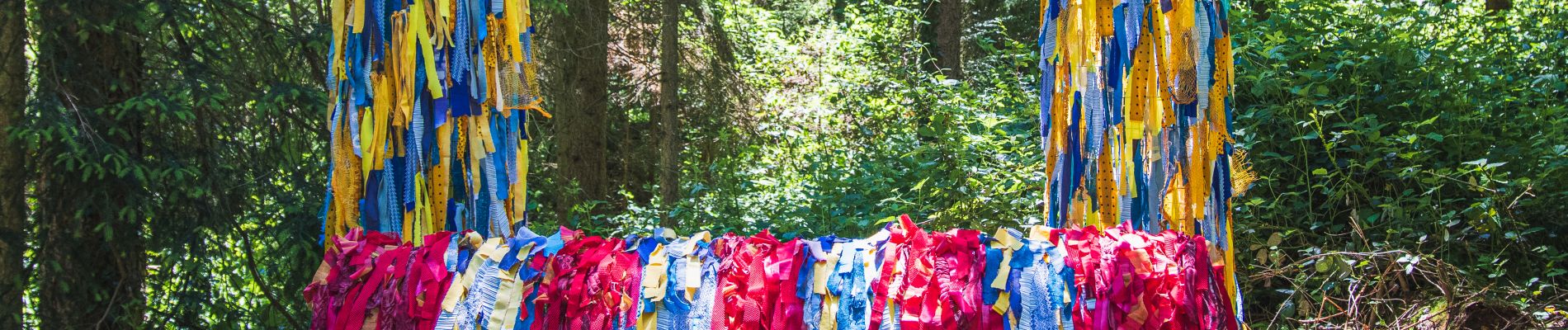
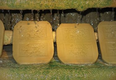
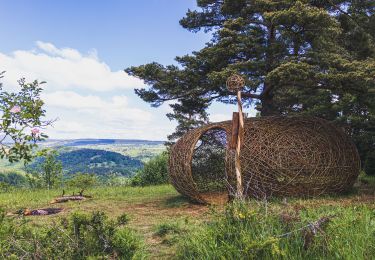
Boucle de 25 min (aller-retour) à la découverte de l'une des œuvres du Festival Horizons Arts-Nature en Sancy 2024 : Green Washing de Muro Atelier. Sur place, le parking et le parcours sont balisés Horizons.
Lave-auto perdu au milieu d'une forêt de hêtres, "Green Washing" est une installation artistique conçue à partir de matériaux réemployés qui raisonne par l'absurde et qui pointe, non sans une certaine ironie, cette volonté contemporaine de se "nettoyer par la nature".
D'autres œuvres de l'édition 2024 d'Horizons sont également disponibles sur SANCY EXPLORER.
Localisation
Commentaires
Randonnées à proximité
![Randonnée Marche Besse-et-Saint-Anastaise - Cascades de Chiloza - Photo](https://media.geolcdn.com/t/375/260/7c04b7ff-fd0b-4381-ace8-4f2ed0ec465b.jpg&format=jpg&maxdim=2)
![Marche Marche](https://static1.geolcdn.com/sitytour/trail-icons/101.png)
Marche
![](/images/other/stat-length.png)
![](https://static1.geolcdn.com/siteimages/upload/files/16400158638029165_repeat_loop_refresh_sync_direction_icon.png)
![Randonnée Marche Saint-Nectaire - Puy de Mazeires - Photo](https://media.geolcdn.com/t/375/260/ext.jpg?maxdim=2&url=https%3A%2F%2Fservices.sitytrail.com%2FGeolivesWS%2FDownloadMedia.ashx%3FTrailID%3D103283%26Media%3D5249_2.jpg)
![Marche Marche](https://static1.geolcdn.com/sitytour/trail-icons/101.png)
Marche
![](/images/other/stat-length.png)
![](https://static1.geolcdn.com/siteimages/upload/files/16400158638029165_repeat_loop_refresh_sync_direction_icon.png)
![Randonnée A pied Saint-Diéry - Le Cheix - Photo](https://media.geolcdn.com/t/375/260/cef373ab-41f4-493d-8694-97c838874352.jpeg&format=jpg&maxdim=2)
![A pied A pied](https://static1.geolcdn.com/sitytour/trail-icons/100.png)
A pied
![](/images/other/stat-length.png)
![](https://static1.geolcdn.com/siteimages/upload/files/16400158638029165_repeat_loop_refresh_sync_direction_icon.png)
![Randonnée A pied Saint-Pierre-Colamine - Ourcière - Photo](https://media.geolcdn.com/t/375/260/bc6ad20d-15b3-4cae-a501-3af9606a455d.jpeg&format=jpg&maxdim=2)
![A pied A pied](https://static1.geolcdn.com/sitytour/trail-icons/100.png)
A pied
![](/images/other/stat-length.png)
![](https://static1.geolcdn.com/siteimages/upload/files/16400158638029165_repeat_loop_refresh_sync_direction_icon.png)
![Randonnée A pied Saint-Victor-la-Rivière - Roche-Romaine - Photo](https://media.geolcdn.com/t/375/260/1195538e-2104-44a1-ae1b-35562b28c916.jpeg&format=jpg&maxdim=2)
![A pied A pied](https://static1.geolcdn.com/sitytour/trail-icons/100.png)
A pied
![](/images/other/stat-length.png)
![](https://static1.geolcdn.com/siteimages/upload/files/16400158638029165_repeat_loop_refresh_sync_direction_icon.png)
![Randonnée A pied Saurier - Le Pic de Brionnet - Photo](https://media.geolcdn.com/t/375/260/6e33ab27-c788-4f32-8c30-5bc1de6dd66f.jpeg&format=jpg&maxdim=2)
![A pied A pied](https://static1.geolcdn.com/sitytour/trail-icons/100.png)
A pied
![](/images/other/stat-length.png)
![](https://static1.geolcdn.com/siteimages/upload/files/16400158638029165_repeat_loop_refresh_sync_direction_icon.png)
![Randonnée A pied Saint-Nectaire - Le Puy d'Eraigne - Photo](https://media.geolcdn.com/t/375/260/a72e12dc-39c4-4fcd-a52d-6f8637845b30.jpeg&format=jpg&maxdim=2)
![A pied A pied](https://static1.geolcdn.com/sitytour/trail-icons/100.png)
A pied
![](/images/other/stat-length.png)
![](https://static1.geolcdn.com/siteimages/upload/files/16400158638029165_repeat_loop_refresh_sync_direction_icon.png)
![Randonnée Marche Saint-Victor-la-Rivière - Horizons 2024 : Ecrin torique - Saint-Victor-la-Rivière - Photo](https://media.geolcdn.com/t/375/260/31860f13-c7b5-4482-828f-5c2e20f5ca3f.jpg&format=jpg&maxdim=2)
![Marche Marche](https://static1.geolcdn.com/sitytour/trail-icons/101.png)
Marche
![](/images/other/stat-length.png)
![](https://static1.geolcdn.com/siteimages/upload/files/16400158638029165_repeat_loop_refresh_sync_direction_icon.png)
![Randonnée Marche Courgoul - Les-Gorges-de-Courgoul-Marcenat_T - Photo](https://media.geolcdn.com/t/375/260/78d4684c-2220-458c-aac4-f2b1ac8cba79.jpg&format=jpg&maxdim=2)
![Marche Marche](https://static1.geolcdn.com/sitytour/trail-icons/101.png)
Marche
![](/images/other/stat-length.png)
![](https://static1.geolcdn.com/siteimages/upload/files/16400158638029165_repeat_loop_refresh_sync_direction_icon.png)