


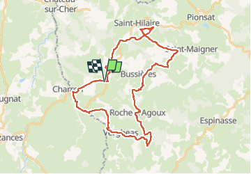

16,1 km | 21 km-effort


Utilisateur


Application GPS de randonnée GRATUITE
 SityTrail
IGN / Instituts géographiques
SityTrail World
Le monde est à vous
Randonnée V.T.T. de 37 km à découvrir à Auvergne-Rhône-Alpes, Puy-de-Dôme, Saint-Maurice-près-Pionsat. Cette randonnée est proposée par CHABASSIER.
A pied

A pied
Marche
Marche

V.T.T.

Marche
Marche
Marche
Marche