![](/images/other/stat-length.png)
![Randonnée Marche Lelin-Lapujolle - St Jacques Étape 29 réalisée - Photo](https://media.geolcdn.com/t/1900/400/ext.pjpeg?maxdim=2&url=https%3A%2F%2Fstatic1.geolcdn.com%2Fsiteimages%2Fupload%2Ffiles%2F1553511878bg_sport_marche.png)
St Jacques Étape 29 réalisée
Jean-MarieFaux
Utilisateur
![Longueur](/images/other/stat-length.png)
Longueur
24 km
![Altitude max](https://static1.geolcdn.com/siteimages/upload/files/1508320355ic_sort_altitude_max_24dp.png)
Altitude max
171 m
![Dénivelé positif](https://static1.geolcdn.com/siteimages/upload/files/1508320355ic_sort_den_pos_24dp.png)
Dénivelé positif
239 m
![Km-Effort](/images/other/stat-length.png)
Km-Effort
27 km
![Altitude min](https://static1.geolcdn.com/siteimages/upload/files/1508320355ic_sort_altitude_min_24dp.png)
Altitude min
78 m
![Dénivelé négatif](https://static1.geolcdn.com/siteimages/upload/files/1508320355ic_sort_den_neg_24dp.png)
Dénivelé négatif
206 m
![Boucle](https://static1.geolcdn.com/siteimages/upload/files/16400158638029165_repeat_loop_refresh_sync_direction_icon.png)
Boucle
Non
Date de création :
2016-03-09 00:00:00.0
Dernière modification :
2016-03-09 00:00:00.0
![Marche](https://static1.geolcdn.com/sitytour/trail-icons/101.png)
6h09
Difficulté : Très facile
![Scannez ce code QR pour ouvrir la randonnée dans l'application SityTrail](https://capi.geolives.com/qq0zvz2zws4bq2lad0pu/sitytour/trails/413974/qr.png?size=200)
Application GPS de randonnée GRATUITE
À propos
Randonnée Marche de 24 km à découvrir à Occitanie, Gers, Lelin-Lapujolle. Cette randonnée est proposée par Jean-MarieFaux.
Description
De Manciet à la D 62 en passant par Aire sur Adour. Étape très plate avant Aire sur Adour. Très beau Lac Brousseau. Retour après au longue ligne droite entre les champs de maïs
Localisation
Pays :
France
Région :
Occitanie
Département/Province :
Gers
Commune :
Lelin-Lapujolle
Localité :
Unknown
Départ:(Dec)
Départ:(UTM)
730563 ; 4844049 (30T) N.
Commentaires
Randonnées à proximité
![Marche Marche](https://static1.geolcdn.com/sitytour/trail-icons/101.png)
CC_Velay_FA_24_Lanne-Soubiran_Aire-Adour_20081109
Marche
Facile
Lanne-Soubiran,
Occitanie,
Gers,
France
![](/images/other/stat-length.png)
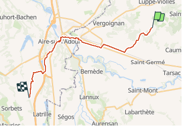
25 km | 29 km-effort
6h 15min
![](https://static1.geolcdn.com/siteimages/upload/files/16400158638029165_repeat_loop_refresh_sync_direction_icon.png)
Non
![Randonnée Marche Lelin-Lapujolle - Compostelle 2 étapes Lelin Miramont Pomps - Photo](https://media.geolcdn.com/t/375/260/ext.jpg?maxdim=2&url=https%3A%2F%2Fstatic1.geolcdn.com%2Fsiteimages%2Fupload%2Ffiles%2F1553511878bg_sport_marche.png)
![Marche Marche](https://static1.geolcdn.com/sitytour/trail-icons/101.png)
Compostelle 2 étapes Lelin Miramont Pomps
Marche
Moyen
Lelin-Lapujolle,
Occitanie,
Gers,
France
![](/images/other/stat-length.png)
78 km | 92 km-effort
15h 17min
![](https://static1.geolcdn.com/siteimages/upload/files/16400158638029165_repeat_loop_refresh_sync_direction_icon.png)
Non
![Randonnée Marche Lanne-Soubiran - Compostelle 22 1er Etape - Photo](https://media.geolcdn.com/t/375/260/ext.jpg?maxdim=2&url=https%3A%2F%2Fstatic1.geolcdn.com%2Fsiteimages%2Fupload%2Ffiles%2F1553511878bg_sport_marche.png)
![Marche Marche](https://static1.geolcdn.com/sitytour/trail-icons/101.png)
Compostelle 22 1er Etape
Marche
Facile
Lanne-Soubiran,
Occitanie,
Gers,
France
![](/images/other/stat-length.png)
18,8 km | 21 km-effort
4h 51min
![](https://static1.geolcdn.com/siteimages/upload/files/16400158638029165_repeat_loop_refresh_sync_direction_icon.png)
Non
![Randonnée Marche Lanne-Soubiran - Aire sur l'Adour - Photo](https://media.geolcdn.com/t/375/260/ext.jpg?maxdim=2&url=https%3A%2F%2Fstatic1.geolcdn.com%2Fsiteimages%2Fupload%2Ffiles%2F1553511878bg_sport_marche.png)
![Marche Marche](https://static1.geolcdn.com/sitytour/trail-icons/101.png)
Aire sur l'Adour
Marche
Facile
Lanne-Soubiran,
Occitanie,
Gers,
France
![](/images/other/stat-length.png)
22 km | 25 km-effort
9h 40min
![](https://static1.geolcdn.com/siteimages/upload/files/16400158638029165_repeat_loop_refresh_sync_direction_icon.png)
Non
![Randonnée Marche Arblade-le-Bas - OR-6947886--Arblade-le-Bas:Airblade le bas-mirmont-sensacq-8 - Photo](https://media.geolcdn.com/t/375/260/ext.jpg?maxdim=2&url=https%3A%2F%2Fstatic1.geolcdn.com%2Fsiteimages%2Fupload%2Ffiles%2F1553511878bg_sport_marche.png)
![Marche Marche](https://static1.geolcdn.com/sitytour/trail-icons/101.png)
OR-6947886--Arblade-le-Bas:Airblade le bas-mirmont-sensacq-8
Marche
Très facile
Arblade-le-Bas,
Occitanie,
Gers,
France
![](/images/other/stat-length.png)
26 km | 30 km-effort
6h 34min
![](https://static1.geolcdn.com/siteimages/upload/files/16400158638029165_repeat_loop_refresh_sync_direction_icon.png)
Non
![Randonnée Marche nordique Lanne-Soubiran - De Miramont-Sensac à Aire-sur-Adour - Photo](https://media.geolcdn.com/t/375/260/ext.jpg?maxdim=2&url=https%3A%2F%2Fstatic1.geolcdn.com%2Fsiteimages%2Fupload%2Ffiles%2F1545311037marcheuse_200dpi.jpg)
![Marche nordique Marche nordique](https://static1.geolcdn.com/sitytour/trail-icons/102.png)
De Miramont-Sensac à Aire-sur-Adour
Marche nordique
Moyen
Lanne-Soubiran,
Occitanie,
Gers,
France
![](/images/other/stat-length.png)
23 km | 26 km-effort
7h 24min
![](https://static1.geolcdn.com/siteimages/upload/files/16400158638029165_repeat_loop_refresh_sync_direction_icon.png)
Non
![Randonnée Marche Lanne-Soubiran - compostelle lanne Soubiran aire sur Adour - Photo](https://media.geolcdn.com/t/375/260/ext.jpg?maxdim=2&url=https%3A%2F%2Fstatic1.geolcdn.com%2Fsiteimages%2Fupload%2Ffiles%2F1553511878bg_sport_marche.png)
![Marche Marche](https://static1.geolcdn.com/sitytour/trail-icons/101.png)
compostelle lanne Soubiran aire sur Adour
Marche
Très difficile
Lanne-Soubiran,
Occitanie,
Gers,
France
![](/images/other/stat-length.png)
20 km | 23 km-effort
5h 0min
![](https://static1.geolcdn.com/siteimages/upload/files/16400158638029165_repeat_loop_refresh_sync_direction_icon.png)
Non
![Randonnée Marche Lanne-Soubiran - presbytère-Aire sur l'Adour - Photo](https://media.geolcdn.com/t/375/260/ext.jpg?maxdim=2&url=https%3A%2F%2Fstatic1.geolcdn.com%2Fsiteimages%2Fupload%2Ffiles%2F1553511878bg_sport_marche.png)
![Marche Marche](https://static1.geolcdn.com/sitytour/trail-icons/101.png)
presbytère-Aire sur l'Adour
Marche
Très difficile
Lanne-Soubiran,
Occitanie,
Gers,
France
![](/images/other/stat-length.png)
21 km | 23 km-effort
4h 46min
![](https://static1.geolcdn.com/siteimages/upload/files/16400158638029165_repeat_loop_refresh_sync_direction_icon.png)
Non
![Randonnée Marche Lanne-Soubiran - 70_19_02 Lanne-Soubiran Aire Sur - Photo](https://media.geolcdn.com/t/375/260/ext.jpg?maxdim=2&url=https%3A%2F%2Fstatic1.geolcdn.com%2Fsiteimages%2Fupload%2Ffiles%2F1553511878bg_sport_marche.png)
![Marche Marche](https://static1.geolcdn.com/sitytour/trail-icons/101.png)
70_19_02 Lanne-Soubiran Aire Sur
Marche
Facile
Lanne-Soubiran,
Occitanie,
Gers,
France
![](/images/other/stat-length.png)
19,8 km | 23 km-effort
5h 7min
![](https://static1.geolcdn.com/siteimages/upload/files/16400158638029165_repeat_loop_refresh_sync_direction_icon.png)
Non