Randonnée Canoë - kayak Châteaudun - Kayak chateaudun - Photo
© OpenStreetMap contributors
Longueur
Longueur
6,6 km
Altitude max
Altitude max
124 m
Dénivelé positif
Dénivelé positif
49 m
Km-Effort
Km-Effort  
7,3 km
Altitude min
Altitude min
106 m
Dénivelé négatif
Dénivelé négatif
48 m
Boucle
Boucle
Oui
Date de création :
2024-07-30 14:33:32.0
Dernière modification :
2024-07-30 16:33:37.62

(0 Avis)

Canoë - kayak
Canoë - kayak
1h59
Difficulté : Inconnu

Scannez ce code QR pour ouvrir la randonnée dans l'application SityTrail

Application GPS de randonnée GRATUITE

Logo SityTrail SityTrail

IGN / Instituts géographiques

Télécharger SityTrail sur l'App Store Télécharger SityTrail sur Google Play

Logo SityTrail SityTrail World

Le monde est à vous

Télécharger SityTrail sur l'App Store Télécharger SityTrail sur Google Play Télécharger SityTrail sur Huawei AppGallery

À propos

Randonnée Canoë - kayak de 6,6 km à découvrir à Centre-Val de Loire, Eure-et-Loir, Châteaudun. Cette randonnée est proposée par 000549.ac9dea4f1351435185fde59f3be1c7e2.1846.

Profil altimétrique

Localisation

Pays :
France
Région :
Centre-Val de Loire
Département/Province :
Eure-et-Loir
Commune :
Châteaudun
Localité :
Unknown
Départ:(Dec)
Départ:(UTM)
375993 ; 5326845 (31U) N.

Randonnées à proximité

Randonnée Marche Châteaudun - Châteaudun - Marboué - Photo
Marche
guydu41

Marche

Moyen
Châteaudun, Centre-Val de Loire, Eure-et-Loir, France
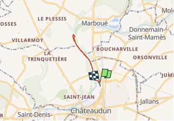
19,2 km | 22 km-effort
6h 25min
Oui
Randonnée V.T.T. Châteaudun - Le moulin de Courgain - Châteaudin - Photo
V.T.T.
tracegps

V.T.T.

Difficile
Châteaudun, Centre-Val de Loire, Eure-et-Loir, France
33 km | 39 km-effort
1h 49min
Oui
Randonnée Marche Châteaudun - Châteaudun 1 - Photo
Marche
RC76

Marche

Moyen
Châteaudun, Centre-Val de Loire, Eure-et-Loir, France
9 km | 10,2 km-effort
2h 46min
Oui
Randonnée A pied Châteaudun - Châteaudun PC25sept2020 - Photo
A pied
CRUZILLACP

A pied

Moyen
Châteaudun, Centre-Val de Loire, Eure-et-Loir, France
9,6 km | 11,1 km-effort
Inconnu
Oui
Randonnée Marche nordique Châteaudun - Marche_Chateaudun_20140326 - Photo
Marche nordique
chlafaille

Marche nordique

Difficile
Châteaudun, Centre-Val de Loire, Eure-et-Loir, France
21 km | 24 km-effort
3h 42min
Oui
Randonnée V.T.T. Châteaudun - Le moulin de Courgain - Chateaudin - Photo
V.T.T.
tracegps

V.T.T.

Difficile
Châteaudun, Centre-Val de Loire, Eure-et-Loir, France
34 km | 39 km-effort
1h 49min
Oui
Randonnée Marche Châteaudun - Chateaudun (Boucle Plaines et Vallées du Dunois) - Photo
Marche
PatrickMatuszewski

Marche

Facile
Châteaudun, Centre-Val de Loire, Eure-et-Loir, France
18,9 km | 22 km-effort
4h 47min
Oui
Randonnée Marche Châteaudun - 009 Chateaudun Cloyes - Photo
Marche
lucille

Marche

Très facile
Châteaudun, Centre-Val de Loire, Eure-et-Loir, France
13,6 km | 15 km-effort
3h 19min
Non
Randonnée Canoë - kayak Saint-Christophe - Kayak  - Photo
Canoë - kayak
000549.ac9dea4f1351435185fde59f3be1c7e2.1846

Canoë - kayak

Saint-Christophe, Centre-Val de Loire, Eure-et-Loir, France
9,5 km | 10,3 km-effort
3h 5min
Non


Fermer
Mes abonnements