![](/images/other/stat-length.png)
![Randonnée Marche Arphy - G4_Cascade-Orgon-par-cap-de-cote-col-de-la-lusette - Photo](https://media.geolcdn.com/t/1900/400/ext.pjpeg?maxdim=2&url=https%3A%2F%2Fstatic1.geolcdn.com%2Fsiteimages%2Fupload%2Ffiles%2F1553511878bg_sport_marche.png)
G4_Cascade-Orgon-par-cap-de-cote-col-de-la-lusette
mamyln
Utilisateur
![Longueur](/images/other/stat-length.png)
![Altitude max](https://static1.geolcdn.com/siteimages/upload/files/1508320355ic_sort_altitude_max_24dp.png)
![Dénivelé positif](https://static1.geolcdn.com/siteimages/upload/files/1508320355ic_sort_den_pos_24dp.png)
![Km-Effort](/images/other/stat-length.png)
![Altitude min](https://static1.geolcdn.com/siteimages/upload/files/1508320355ic_sort_altitude_min_24dp.png)
![Dénivelé négatif](https://static1.geolcdn.com/siteimages/upload/files/1508320355ic_sort_den_neg_24dp.png)
![Boucle](https://static1.geolcdn.com/siteimages/upload/files/16400158638029165_repeat_loop_refresh_sync_direction_icon.png)
![Marche](https://static1.geolcdn.com/sitytour/trail-icons/101.png)
5h13
Difficulté : Très difficile
![Scannez ce code QR pour ouvrir la randonnée dans l'application SityTrail](https://capi.geolives.com/qq0zvz2zws4bq2lad0pu/sitytour/trails/4137898/qr.png?size=200)
Application GPS de randonnée GRATUITE
À propos
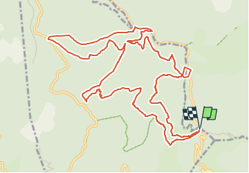
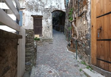
Randonnée Marche de 16,1 km à découvrir à Occitanie, Gard, Arphy. Cette randonnée est proposée par mamyln.
Description
16km_512m_IBP57_
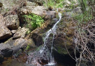
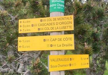
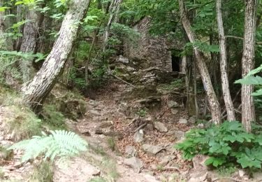
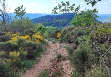
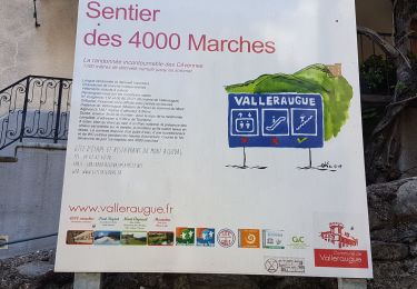
passage aux cols de la Lusette (tour de france 2020) et Montals avec une altitude max de 1420m, puis les cascades d’Orgon (pique-nique), superbe paysage sur les Cévennes descente difficile sur plusieurs mètres.
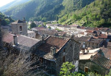
Trajet 60km via Ganges, Pont d'Hérault/L'Arre/MandagoutD329 jusqu'à l'arrivée au Parking du gite Cap de Coté
Localisation
Commentaires
Randonnées à proximité
![Randonnée Marche Arphy - Cascade d'Orgon/ monument André Chamson - Photo](https://media.geolcdn.com/t/375/260/e2360f77-e72b-40ce-8fc1-3dfbe5c83de1.jpg&format=jpg&maxdim=2)
![Marche Marche](https://static1.geolcdn.com/sitytour/trail-icons/101.png)
Marche
![](/images/other/stat-length.png)
![](https://static1.geolcdn.com/siteimages/upload/files/16400158638029165_repeat_loop_refresh_sync_direction_icon.png)
![Randonnée Marche Val-d'Aigoual - col de la Lusette - Pic de Barette - col de Montals - L'Espérou - Photo](https://media.geolcdn.com/t/375/260/ext.jpg?maxdim=2&url=https%3A%2F%2Fstatic1.geolcdn.com%2Fsiteimages%2Fupload%2Ffiles%2F1553511878bg_sport_marche.png)
![Marche Marche](https://static1.geolcdn.com/sitytour/trail-icons/101.png)
Marche
![](/images/other/stat-length.png)
![](https://static1.geolcdn.com/siteimages/upload/files/16400158638029165_repeat_loop_refresh_sync_direction_icon.png)
![Randonnée Marche Arphy - Vallée du Coudoulous - Photo](https://media.geolcdn.com/t/375/260/90b23482-1146-4b41-9230-9b53612810b5.jpg&format=jpg&maxdim=2)
![Marche Marche](https://static1.geolcdn.com/sitytour/trail-icons/101.png)
Marche
![](/images/other/stat-length.png)
![](https://static1.geolcdn.com/siteimages/upload/files/16400158638029165_repeat_loop_refresh_sync_direction_icon.png)
![Randonnée Marche Arphy - Arphy - Photo](https://media.geolcdn.com/t/375/260/e231fcad-fb6d-4760-a6f9-b9c27668256a.jpg&format=jpg&maxdim=2)
![Marche Marche](https://static1.geolcdn.com/sitytour/trail-icons/101.png)
![Randonnée Marche Val-d'Aigoual - Cascade d'Orgon-15-06-22 - Photo](https://media.geolcdn.com/t/375/260/49ac4d00-981a-43cf-b1d1-af4b0eb1b9db.jpg&format=jpg&maxdim=2)
![Marche Marche](https://static1.geolcdn.com/sitytour/trail-icons/101.png)
Marche
![](/images/other/stat-length.png)
![](https://static1.geolcdn.com/siteimages/upload/files/16400158638029165_repeat_loop_refresh_sync_direction_icon.png)
![Randonnée Marche Val-d'Aigoual - 4000 marches-14-06-22 - Photo](https://media.geolcdn.com/t/375/260/d1c0910b-e80d-4616-bf52-2645b3da4871.jpg&format=jpg&maxdim=2)
![Marche Marche](https://static1.geolcdn.com/sitytour/trail-icons/101.png)
Marche
![](/images/other/stat-length.png)
![](https://static1.geolcdn.com/siteimages/upload/files/16400158638029165_repeat_loop_refresh_sync_direction_icon.png)
![Randonnée Marche Val-d'Aigoual - L'Esperou Le Vigan GR 7 - Photo](https://media.geolcdn.com/t/375/260/46e8ebd9-240d-4741-8e1d-a008b70dff36.jpg&format=jpg&maxdim=2)
![Marche Marche](https://static1.geolcdn.com/sitytour/trail-icons/101.png)
Marche
![](/images/other/stat-length.png)
![](https://static1.geolcdn.com/siteimages/upload/files/16400158638029165_repeat_loop_refresh_sync_direction_icon.png)
![Randonnée A pied Val-d'Aigoual - Les 4000 marches - Photo](https://media.geolcdn.com/t/375/260/524f6c51-5088-4b94-8b4b-21ac59ca5a00.jpeg&format=jpg&maxdim=2)
![A pied A pied](https://static1.geolcdn.com/sitytour/trail-icons/100.png)
A pied
![](/images/other/stat-length.png)
![](https://static1.geolcdn.com/siteimages/upload/files/16400158638029165_repeat_loop_refresh_sync_direction_icon.png)
![Randonnée Marche Val-d'Aigoual - Montée Aigoual et descente par Aire de Côte - Photo](https://media.geolcdn.com/t/375/260/83d13ddb-7390-4a71-be58-29aa48f18c9a.jpg&format=jpg&maxdim=2)
![Marche Marche](https://static1.geolcdn.com/sitytour/trail-icons/101.png)
Marche
![](/images/other/stat-length.png)
![](https://static1.geolcdn.com/siteimages/upload/files/16400158638029165_repeat_loop_refresh_sync_direction_icon.png)