Randonnée Cyclotourisme Ouroux-sur-Saône - Jura J4/8  Ouroux à  Chatillon - Photo
 ericf64
ericf64

Utilisateur

© OpenStreetMap contributors
Longueur
Longueur
84 km
Altitude max
Altitude max
544 m
Dénivelé positif
Dénivelé positif
1073 m
Km-Effort
Km-Effort  
97 km
Altitude min
Altitude min
177 m
Dénivelé négatif
Dénivelé négatif
785 m
Boucle
Boucle
Non
Date de création :
2024-07-27 07:03:32.56
Dernière modification :
2024-08-01 11:22:50.218

(0 Avis)

Cyclotourisme
Cyclotourisme
9h27
Difficulté : Moyen

Scannez ce code QR pour ouvrir la randonnée dans l'application SityTrail

Application GPS de randonnée GRATUITE

Logo SityTrail SityTrail

IGN / Instituts géographiques

Télécharger SityTrail sur l'App Store Télécharger SityTrail sur Google Play

Logo SityTrail SityTrail World

Le monde est à vous

Télécharger SityTrail sur l'App Store Télécharger SityTrail sur Google Play Télécharger SityTrail sur Huawei AppGallery

À propos

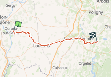
Randonnée Cyclotourisme de 84 km à découvrir à Bourgogne-Franche-Comté, Saône-et-Loire, Ouroux-sur-Saône. Cette randonnée est proposée par ericf64.

Profil altimétrique

Localisation

Pays :
France
Région :
Bourgogne-Franche-Comté
Département/Province :
Saône-et-Loire
Commune :
Ouroux-sur-Saône
Localité :
Unknown
Départ:(UTM)
651209 ; 5175794 (31T) N.

Randonnées à proximité

Randonnée A pied Saint-Germain-du-Plain - De ST Germain au Jacquots , Abbaye des Barres , Serville et retour par le bois de la tuilerie  - Photo
A pied
jeanpaulcheyssac

A pied

Facile
Saint-Germain-du-Plain, Bourgogne-Franche-Comté, Saône-et-Loire, France
9,4 km | 10,5 km-effort
2h 23min
Oui
Randonnée A pied Saint-Germain-du-Plain - De St Germain à St Germain par voie verte , les Durandard , les Jacquots , Petit Limon et retour par Marosse  - Photo
A pied
jeanpaulcheyssac

A pied

Facile
Saint-Germain-du-Plain, Bourgogne-Franche-Comté, Saône-et-Loire, France
10,7 km | 11,7 km-effort
2h 39min
Oui
Randonnée A pied L'Abergement-Sainte-Colombe - Abergement , Villargeau , le Vernay Morin , le Charmois , les Plates  - Photo
A pied
jeanpaulcheyssac

A pied

Facile
L'Abergement-Sainte-Colombe, Bourgogne-Franche-Comté, Saône-et-Loire, France
6,8 km | 7,5 km-effort
1h 42min
Oui
Randonnée A pied Saint-Germain-du-Plain - De St Germain du plain aux Jacquots , retour par le bois des vernes  - Photo
A pied
jeanpaulcheyssac

A pied

Facile
Saint-Germain-du-Plain, Bourgogne-Franche-Comté, Saône-et-Loire, France
6,4 km | 7,1 km-effort
1h 36min
Oui
Randonnée A pied Ouroux-sur-Saône - Ouroux sur Saône , les platières , Grand Servigny et retour  - Photo
A pied
jeanpaulcheyssac

A pied

Facile
Ouroux-sur-Saône, Bourgogne-Franche-Comté, Saône-et-Loire, France
6 km | 6,4 km-effort
1h 26min
Oui
Randonnée A pied L'Abergement-Sainte-Colombe - Abergement St Colombe , champ Salin , pré Bretin , champ Bouchoux , les vernes et retour  - Photo
A pied
jeanpaulcheyssac

A pied

Facile
L'Abergement-Sainte-Colombe, Bourgogne-Franche-Comté, Saône-et-Loire, France
6 km | 6,5 km-effort
1h 29min
Oui
Randonnée A pied Ouroux-sur-Saône - TP - D' Ouroux déchéterie par la voie verte - Bizon , Grancière et retour voie verte  - Photo
A pied
jeanpaulcheyssac

A pied

Facile
Ouroux-sur-Saône, Bourgogne-Franche-Comté, Saône-et-Loire, France
6,1 km | 6,6 km-effort
1h 29min
Oui
Randonnée A pied Ouroux-sur-Saône - P - D' Ouroux déchéterie au site
A pied
jeanpaulcheyssac

A pied

Facile
Ouroux-sur-Saône, Bourgogne-Franche-Comté, Saône-et-Loire, France
9,4 km | 10 km-effort
2h 16min
Oui
Randonnée A pied Saint-Christophe-en-Bresse - St Christophe , Les mourillons , Petit Servigny , carré maudit  - Photo
A pied
jeanpaulcheyssac

A pied

Facile
Saint-Christophe-en-Bresse, Bourgogne-Franche-Comté, Saône-et-Loire, France
6 km | 6,8 km-effort
1h 32min
Oui


Fermer
Mes abonnements