Randonnée V.T.T. Clausthal-Zellerfeld - Broken - Photo
 LauVan
LauVan

Utilisateur

© OpenStreetMap contributors
Longueur
Longueur
51 km
Altitude max
Altitude max
1129 m
Dénivelé positif
Dénivelé positif
1278 m
Km-Effort
Km-Effort  
68 km
Altitude min
Altitude min
414 m
Dénivelé négatif
Dénivelé négatif
1279 m
Boucle
Boucle
Oui
Date de création :
2024-07-25 08:56:43.572
Dernière modification :
2024-07-25 14:10:01.319

(0 Avis)

V.T.T.
V.T.T.
5h12
Difficulté : Difficile

Scannez ce code QR pour ouvrir la randonnée dans l'application SityTrail

Application GPS de randonnée GRATUITE

Logo SityTrail SityTrail

IGN / Instituts géographiques

Télécharger SityTrail sur l'App Store Télécharger SityTrail sur Google Play

Logo SityTrail SityTrail World

Le monde est à vous

Télécharger SityTrail sur l'App Store Télécharger SityTrail sur Google Play Télécharger SityTrail sur Huawei AppGallery

À propos

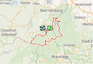
Randonnée V.T.T. de 51 km à découvrir à Basse-Saxe, Goslar (arrondissement), Clausthal-Zellerfeld. Cette randonnée est proposée par LauVan.

Profil altimétrique

Localisation

Pays :
Allemagne
Région :
Basse-Saxe
Département/Province :
Goslar (arrondissement)
Commune :
Clausthal-Zellerfeld
Localité :
Altenau - Schulenberg i.O.
Départ:(UTM)
605995 ; 5740118 (32U) N.

Randonnées à proximité

Randonnée A pied Harz (LK Goslar) - HK 7: Bad Grund - Okertal - Bad Harzburg - Photo
A pied
PRO

A pied

Facile
Harz (LK Goslar), Basse-Saxe, Goslar (arrondissement), Allemagne
7,8 km | 10,1 km-effort
2h 18min
Non
Randonnée A pied Clausthal-Zellerfeld - Rund um das Große Torfhausmoor - Photo
A pied
PRO

A pied

Facile
Clausthal-Zellerfeld, Basse-Saxe, Goslar (arrondissement), Allemagne
4,9 km | 6 km-effort
1h 22min
Non
Randonnée A pied Harz (LK Goslar) - Eckertalsperren-Rundweg - Photo
A pied
PRO

A pied

Facile
Harz (LK Goslar), Basse-Saxe, Goslar (arrondissement), Allemagne
8,5 km | 10,4 km-effort
2h 21min
Oui
Randonnée A pied Harz (LK Goslar) - Harzklub-Weg 10G - Photo
A pied
PRO

A pied

Facile
Harz (LK Goslar), Basse-Saxe, Goslar (arrondissement), Allemagne
3,3 km | 3,8 km-effort
52min
Non
Randonnée A pied Clausthal-Zellerfeld - Goetheweg - Photo
A pied
PRO

A pied

Facile
Clausthal-Zellerfeld, Basse-Saxe, Goslar (arrondissement), Allemagne
8,6 km | 12,1 km-effort
2h 45min
Non
Randonnée A pied Harz (LK Goslar) - Rehberger Graben - Photo
A pied
PRO

A pied

Facile
Harz (LK Goslar), Basse-Saxe, Goslar (arrondissement), Allemagne
7,4 km | 8,9 km-effort
2h 1min
Non
Randonnée Trail Harz (LK Goslar) - Tarfhaus - Photo
Trail
LauVan

Trail

Facile
Harz (LK Goslar), Basse-Saxe, Goslar (arrondissement), Allemagne
9,7 km | 14,1 km-effort
1h 15min
Non
Randonnée Marche Clausthal-Zellerfeld - tarfhaismoor - Photo
Marche
LauVan

Marche

Très facile
Clausthal-Zellerfeld, Basse-Saxe, Goslar (arrondissement), Allemagne
5,5 km | 6,8 km-effort
1h 32min
Oui


Fermer
Mes abonnements