![](/images/other/stat-length.png)
![Randonnée Marche Belfort - Citadelle de Belfort - Photo](https://media.geolcdn.com/t/1900/400/ext.pjpeg?maxdim=2&url=https%3A%2F%2Fstatic1.geolcdn.com%2Fsiteimages%2Fupload%2Ffiles%2F1553511878bg_sport_marche.png)
Citadelle de Belfort
Bart2015
Utilisateur
![Longueur](/images/other/stat-length.png)
Longueur
4,3 km
![Altitude max](https://static1.geolcdn.com/siteimages/upload/files/1508320355ic_sort_altitude_max_24dp.png)
Altitude max
428 m
![Dénivelé positif](https://static1.geolcdn.com/siteimages/upload/files/1508320355ic_sort_den_pos_24dp.png)
Dénivelé positif
82 m
![Km-Effort](/images/other/stat-length.png)
Km-Effort
5,3 km
![Altitude min](https://static1.geolcdn.com/siteimages/upload/files/1508320355ic_sort_altitude_min_24dp.png)
Altitude min
360 m
![Dénivelé négatif](https://static1.geolcdn.com/siteimages/upload/files/1508320355ic_sort_den_neg_24dp.png)
Dénivelé négatif
82 m
![Boucle](https://static1.geolcdn.com/siteimages/upload/files/16400158638029165_repeat_loop_refresh_sync_direction_icon.png)
Boucle
Oui
Date de création :
2024-07-21 19:10:54.352
Dernière modification :
2024-07-29 09:00:53.929
![Marche](https://static1.geolcdn.com/sitytour/trail-icons/101.png)
1h12
Difficulté : Facile
![Scannez ce code QR pour ouvrir la randonnée dans l'application SityTrail](https://capi.geolives.com/qq0zvz2zws4bq2lad0pu/sitytour/trails/4129878/qr.png?size=200)
Application GPS de randonnée GRATUITE
À propos
Randonnée Marche de 4,3 km à découvrir à Bourgogne-Franche-Comté, Territoire-de-Belfort, Belfort. Cette randonnée est proposée par Bart2015.
Description
Petite balade dans la citadelle de Belfort à faire de préférence en début de nuit avec des frontales pour l'ambiance ...
Bone balade, soyez prudents ...
Localisation
Pays :
France
Région :
Bourgogne-Franche-Comté
Département/Province :
Territoire-de-Belfort
Commune :
Belfort
Localité :
Unknown
Départ:(Dec)
Départ:(UTM)
339522 ; 5278512 (32T) N.
Commentaires
Randonnées à proximité
![Randonnée V.T.T. Andelnans - Tour d'Essert - Photo](https://media.geolcdn.com/t/375/260/ext.jpg?maxdim=2&url=https%3A%2F%2Fstatic1.geolcdn.com%2Fsiteimages%2Fupload%2Ffiles%2F1524743154velo.jpg)
![V.T.T. V.T.T.](https://static1.geolcdn.com/sitytour/trail-icons/202.png)
Tour d'Essert
V.T.T.
Facile
(2)
Andelnans,
Bourgogne-Franche-Comté,
Territoire-de-Belfort,
France
![](/images/other/stat-length.png)
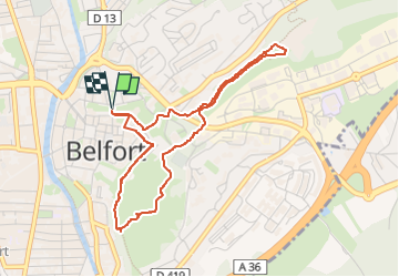
29 km | 36 km-effort
2h 12min
![](https://static1.geolcdn.com/siteimages/upload/files/16400158638029165_repeat_loop_refresh_sync_direction_icon.png)
Oui
![Randonnée Marche Belfort - Offemont - La ballade des Champs Cerisiers - Photo](https://media.geolcdn.com/t/375/260/ext.jpg?maxdim=2&url=https%3A%2F%2Fstatic1.geolcdn.com%2Fsiteimages%2Fupload%2Ffiles%2F1553511878bg_sport_marche.png)
![Marche Marche](https://static1.geolcdn.com/sitytour/trail-icons/101.png)
Offemont - La ballade des Champs Cerisiers
Marche
Facile
(1)
Belfort,
Bourgogne-Franche-Comté,
Territoire-de-Belfort,
France
![](/images/other/stat-length.png)
8,8 km | 10,8 km-effort
Inconnu
![](https://static1.geolcdn.com/siteimages/upload/files/16400158638029165_repeat_loop_refresh_sync_direction_icon.png)
Oui
![Randonnée Marche Sermamagny - Veronne PC - Photo](https://media.geolcdn.com/t/375/260/ext.jpg?maxdim=2&url=https%3A%2F%2Fstatic1.geolcdn.com%2Fsiteimages%2Fupload%2Ffiles%2F1553511878bg_sport_marche.png)
![Marche Marche](https://static1.geolcdn.com/sitytour/trail-icons/101.png)
Veronne PC
Marche
Très facile
(2)
Sermamagny,
Bourgogne-Franche-Comté,
Territoire-de-Belfort,
France
![](/images/other/stat-length.png)
8,1 km | 9 km-effort
1h 59min
![](https://static1.geolcdn.com/siteimages/upload/files/16400158638029165_repeat_loop_refresh_sync_direction_icon.png)
Oui
![Randonnée Marche Offemont - Etang des Forges - Forts de la Miotte et de la Justice - Citadèle et Vieille ville de Belfort - Photo](https://media.geolcdn.com/t/375/260/c26a3ad7-a095-475f-934e-c91591fd50e4.jpg&format=jpg&maxdim=2)
![Marche Marche](https://static1.geolcdn.com/sitytour/trail-icons/101.png)
Etang des Forges - Forts de la Miotte et de la Justice - Citadèle et Vieille ...
Marche
Très difficile
Offemont,
Bourgogne-Franche-Comté,
Territoire-de-Belfort,
France
![](/images/other/stat-length.png)
16,1 km | 19,6 km-effort
4h 27min
![](https://static1.geolcdn.com/siteimages/upload/files/16400158638029165_repeat_loop_refresh_sync_direction_icon.png)
Oui
![Randonnée Vélo électrique Essert - VTT - Essert - Salbert - Vétrigne - Miotte - Citadelle Belfort - Essert - Photo](https://media.geolcdn.com/t/375/260/9ea3754c-f673-4e19-890f-f64e417a9f4d.jpg&format=jpg&maxdim=2)
![Vélo électrique Vélo électrique](https://static1.geolcdn.com/sitytour/trail-icons/205.png)
VTT - Essert - Salbert - Vétrigne - Miotte - Citadelle Belfort - Essert
Vélo électrique
Difficile
Essert,
Bourgogne-Franche-Comté,
Territoire-de-Belfort,
France
![](/images/other/stat-length.png)
42 km | 55 km-effort
4h 55min
![](https://static1.geolcdn.com/siteimages/upload/files/16400158638029165_repeat_loop_refresh_sync_direction_icon.png)
Oui
![Randonnée Moto Évette-Salbert - Moto - Evette - Grand Ballon - Honneck - Lacs de Longemer puis de Gérardmer - chapelle des Vés - Ballon d'Alsace - Photo](https://media.geolcdn.com/t/375/260/7fdb8878-2da7-4fc1-b838-8926082e0304.jpg&format=jpg&maxdim=2)
![Moto Moto](https://static1.geolcdn.com/sitytour/trail-icons/402.png)
Moto - Evette - Grand Ballon - Honneck - Lacs de Longemer puis de Gérardmer -...
Moto
Difficile
Évette-Salbert,
Bourgogne-Franche-Comté,
Territoire-de-Belfort,
France
![](/images/other/stat-length.png)
195 km | 252 km-effort
5h 39min
![](https://static1.geolcdn.com/siteimages/upload/files/16400158638029165_repeat_loop_refresh_sync_direction_icon.png)
Oui
![Randonnée A pied Offemont - Sentier de la Roselière - Photo](https://media.geolcdn.com/t/375/260/c8e60aaf-8ba5-407b-b750-77a1aea99966.jpeg&format=jpg&maxdim=2)
![A pied A pied](https://static1.geolcdn.com/sitytour/trail-icons/100.png)
Sentier de la Roselière
A pied
Facile
Offemont,
Bourgogne-Franche-Comté,
Territoire-de-Belfort,
France
![](/images/other/stat-length.png)
3,9 km | 4,3 km-effort
58min
![](https://static1.geolcdn.com/siteimages/upload/files/16400158638029165_repeat_loop_refresh_sync_direction_icon.png)
Oui
![Randonnée V.T.T. Vézelois - 1er tour avec Olivier - Photo](https://media.geolcdn.com/t/375/260/ext.jpg?maxdim=2&url=https%3A%2F%2Fstatic1.geolcdn.com%2Fsiteimages%2Fupload%2Ffiles%2F1524743154velo.jpg)
![V.T.T. V.T.T.](https://static1.geolcdn.com/sitytour/trail-icons/202.png)
1er tour avec Olivier
V.T.T.
Facile
(1)
Vézelois,
Bourgogne-Franche-Comté,
Territoire-de-Belfort,
France
![](/images/other/stat-length.png)
38 km | 47 km-effort
2h 59min
![](https://static1.geolcdn.com/siteimages/upload/files/16400158638029165_repeat_loop_refresh_sync_direction_icon.png)
Oui
![Randonnée Marche Essert - Essert - Petit Salbert - Photo](https://media.geolcdn.com/t/375/260/ext.jpg?maxdim=2&url=https%3A%2F%2Fstatic1.geolcdn.com%2Fsiteimages%2Fupload%2Ffiles%2F1553511878bg_sport_marche.png)
![Marche Marche](https://static1.geolcdn.com/sitytour/trail-icons/101.png)
Essert - Petit Salbert
Marche
Très facile
(1)
Essert,
Bourgogne-Franche-Comté,
Territoire-de-Belfort,
France
![](/images/other/stat-length.png)
7,4 km | 10,2 km-effort
2h 10min
![](https://static1.geolcdn.com/siteimages/upload/files/16400158638029165_repeat_loop_refresh_sync_direction_icon.png)
Oui