![](/images/other/stat-length.png)
![Randonnée Marche Saint-Étienne-de-Tinée - Étape 3 Refuge de Rabuons / Refuge Alexandris Foche - Photo](https://media.geolcdn.com/t/1900/400/ce51cbac-59ff-4fc7-bafe-30b46d497992.jpg&format=pjpeg&maxdim=2)
Étape 3 Refuge de Rabuons / Refuge Alexandris Foche
domthom
Utilisateur
![Longueur](/images/other/stat-length.png)
Longueur
15,7 km
![Altitude max](https://static1.geolcdn.com/siteimages/upload/files/1508320355ic_sort_altitude_max_24dp.png)
Altitude max
2755 m
![Dénivelé positif](https://static1.geolcdn.com/siteimages/upload/files/1508320355ic_sort_den_pos_24dp.png)
Dénivelé positif
895 m
![Km-Effort](/images/other/stat-length.png)
Km-Effort
30 km
![Altitude min](https://static1.geolcdn.com/siteimages/upload/files/1508320355ic_sort_altitude_min_24dp.png)
Altitude min
1898 m
![Dénivelé négatif](https://static1.geolcdn.com/siteimages/upload/files/1508320355ic_sort_den_neg_24dp.png)
Dénivelé négatif
1499 m
![Boucle](https://static1.geolcdn.com/siteimages/upload/files/16400158638029165_repeat_loop_refresh_sync_direction_icon.png)
Boucle
Non
Date de création :
2024-07-19 06:06:54.135
Dernière modification :
2024-07-21 15:30:16.837
![Marche](https://static1.geolcdn.com/sitytour/trail-icons/101.png)
5h37
Difficulté : Difficile
![Scannez ce code QR pour ouvrir la randonnée dans l'application SityTrail](https://capi.geolives.com/qq0zvz2zws4bq2lad0pu/sitytour/trails/4129500/qr.png?size=200)
Application GPS de randonnée GRATUITE
À propos
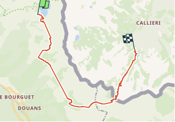
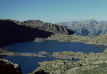
Randonnée Marche de 15,7 km à découvrir à Provence-Alpes-Côte d'Azur, Alpes-Maritimes, Saint-Étienne-de-Tinée. Cette randonnée est proposée par domthom.
Description
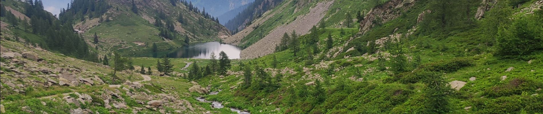
départ bien physique en dénivelé positif. Poursuite en balcon puis descente très longue côté italien jusqu'au lac Bernolfo et le refuge Alexandris Foche.
Localisation
Pays :
France
Région :
Provence-Alpes-Côte d'Azur
Département/Province :
Alpes-Maritimes
Commune :
Saint-Étienne-de-Tinée
Localité :
Unknown
Départ:(Dec)
Départ:(UTM)
338627 ; 4903666 (32T) N.
Commentaires
Randonnées à proximité
![Randonnée Marche Saint-Étienne-de-Tinée - MERCANTOUR - Lac de rabuons - Photo](https://media.geolcdn.com/t/375/260/9be970a9-36fb-4800-8850-f3d8a283d146.jpg&format=jpg&maxdim=2)
![Marche Marche](https://static1.geolcdn.com/sitytour/trail-icons/101.png)
MERCANTOUR - Lac de rabuons
Marche
Très difficile
(1)
Saint-Étienne-de-Tinée,
Provence-Alpes-Côte d'Azur,
Alpes-Maritimes,
France
![](/images/other/stat-length.png)
19,5 km | 40 km-effort
9h 9min
![](https://static1.geolcdn.com/siteimages/upload/files/16400158638029165_repeat_loop_refresh_sync_direction_icon.png)
Non
![Randonnée Marche Saint-Étienne-de-Tinée - Mont Ténibre en boucle depuis Saint Etienne de Tinée - Photo](https://media.geolcdn.com/t/375/260/ext.jpg?maxdim=2&url=https%3A%2F%2Fservices.sitytrail.com%2FGeolivesWS%2FDownloadMedia.ashx%3FTrailID%3D316962%26Media%3D16081_1.jpg)
![Marche Marche](https://static1.geolcdn.com/sitytour/trail-icons/101.png)
Mont Ténibre en boucle depuis Saint Etienne de Tinée
Marche
Très difficile
(4)
Saint-Étienne-de-Tinée,
Provence-Alpes-Côte d'Azur,
Alpes-Maritimes,
France
![](/images/other/stat-length.png)
18 km | 45 km-effort
10h 0min
![](https://static1.geolcdn.com/siteimages/upload/files/16400158638029165_repeat_loop_refresh_sync_direction_icon.png)
Oui
![Randonnée Marche Saint-Étienne-de-Tinée - Lacs de Rabuons et Chaffour - Photo](https://media.geolcdn.com/t/375/260/3c095966-4d41-4343-af9e-eff2f1957790.jpg&format=jpg&maxdim=2)
![Marche Marche](https://static1.geolcdn.com/sitytour/trail-icons/101.png)
Lacs de Rabuons et Chaffour
Marche
Difficile
Saint-Étienne-de-Tinée,
Provence-Alpes-Côte d'Azur,
Alpes-Maritimes,
France
![](/images/other/stat-length.png)
22 km | 46 km-effort
7h 4min
![](https://static1.geolcdn.com/siteimages/upload/files/16400158638029165_repeat_loop_refresh_sync_direction_icon.png)
Oui
![Randonnée Marche Saint-Étienne-de-Tinée - Refuge du Rabuons -- Mt Ténibre A/R -- St Etienne de Tinée - Photo](https://media.geolcdn.com/t/375/260/994ef0cf-20db-466f-991e-cc6124ac559b.jpg&format=jpg&maxdim=2)
![Marche Marche](https://static1.geolcdn.com/sitytour/trail-icons/101.png)
Refuge du Rabuons -- Mt Ténibre A/R -- St Etienne de Tinée
Marche
Très difficile
Saint-Étienne-de-Tinée,
Provence-Alpes-Côte d'Azur,
Alpes-Maritimes,
France
![](/images/other/stat-length.png)
16,7 km | 30 km-effort
6h 20min
![](https://static1.geolcdn.com/siteimages/upload/files/16400158638029165_repeat_loop_refresh_sync_direction_icon.png)
Non
![Randonnée A pied Saint-Étienne-de-Tinée - Circuit du Bois d'Anelle - Photo](https://media.geolcdn.com/t/375/260/33170b65-b2a2-4258-939b-53929311e4fe.jpeg&format=jpg&maxdim=2)
![A pied A pied](https://static1.geolcdn.com/sitytour/trail-icons/100.png)
Circuit du Bois d'Anelle
A pied
Moyen
Saint-Étienne-de-Tinée,
Provence-Alpes-Côte d'Azur,
Alpes-Maritimes,
France
![](/images/other/stat-length.png)
11,3 km | 21 km-effort
4h 40min
![](https://static1.geolcdn.com/siteimages/upload/files/16400158638029165_repeat_loop_refresh_sync_direction_icon.png)
Oui
![Randonnée A pied Saint-Étienne-de-Tinée - Circuit de Selasse - Photo](https://media.geolcdn.com/t/375/260/dfb717e2-6ad9-4c5c-8a23-b53a05088fa8.jpeg&format=jpg&maxdim=2)
![A pied A pied](https://static1.geolcdn.com/sitytour/trail-icons/100.png)
Circuit de Selasse
A pied
Facile
Saint-Étienne-de-Tinée,
Provence-Alpes-Côte d'Azur,
Alpes-Maritimes,
France
![](/images/other/stat-length.png)
6,3 km | 15,1 km-effort
3h 25min
![](https://static1.geolcdn.com/siteimages/upload/files/16400158638029165_repeat_loop_refresh_sync_direction_icon.png)
Oui
![Randonnée A pied Saint-Étienne-de-Tinée - Cime de la Bercha - Photo](https://media.geolcdn.com/t/375/260/06e4d46f-e317-406d-bd2c-01041e541c38.jpeg&format=jpg&maxdim=2)
![A pied A pied](https://static1.geolcdn.com/sitytour/trail-icons/100.png)
Cime de la Bercha
A pied
Facile
Saint-Étienne-de-Tinée,
Provence-Alpes-Côte d'Azur,
Alpes-Maritimes,
France
![](/images/other/stat-length.png)
9,3 km | 18,1 km-effort
4h 7min
![](https://static1.geolcdn.com/siteimages/upload/files/16400158638029165_repeat_loop_refresh_sync_direction_icon.png)
Oui
![Randonnée A pied Saint-Étienne-de-Tinée - Chemin de l'Energie - Etape 3 - Photo](https://media.geolcdn.com/t/375/260/45dc2ef9-a27b-439a-8012-c03ab217c2f9.jpeg&format=jpg&maxdim=2)
![A pied A pied](https://static1.geolcdn.com/sitytour/trail-icons/100.png)
Chemin de l'Energie - Etape 3
A pied
Facile
Saint-Étienne-de-Tinée,
Provence-Alpes-Côte d'Azur,
Alpes-Maritimes,
France
![](/images/other/stat-length.png)
8,4 km | 14,4 km-effort
3h 15min
![](https://static1.geolcdn.com/siteimages/upload/files/16400158638029165_repeat_loop_refresh_sync_direction_icon.png)
Non
![Randonnée A pied Saint-Étienne-de-Tinée - Mont Ténibre - Photo](https://media.geolcdn.com/t/375/260/e4d2ef1c-7332-48ac-8d35-d330e68b6f30.jpeg&format=jpg&maxdim=2)
![A pied A pied](https://static1.geolcdn.com/sitytour/trail-icons/100.png)
Mont Ténibre
A pied
Très difficile
Saint-Étienne-de-Tinée,
Provence-Alpes-Côte d'Azur,
Alpes-Maritimes,
France
![](/images/other/stat-length.png)
24 km | 52 km-effort
11h 45min
![](https://static1.geolcdn.com/siteimages/upload/files/16400158638029165_repeat_loop_refresh_sync_direction_icon.png)
Oui