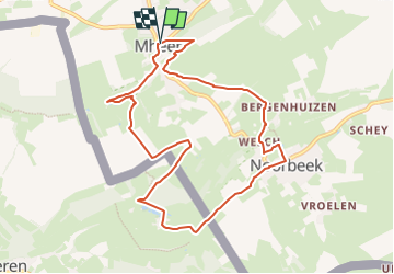
![](/images/other/stat-length.png)
![Randonnée Marche Eijsden-Margraten - Mheer MH1 - Photo](https://media.geolcdn.com/t/1900/400/3a5ffec1-2320-491b-8121-fd47dcf74f8e.jpg&format=pjpeg&maxdim=2)
Mheer MH1
mumu.larandonneuse
Utilisateur GUIDE
![Longueur](/images/other/stat-length.png)
![Altitude max](https://static1.geolcdn.com/siteimages/upload/files/1508320355ic_sort_altitude_max_24dp.png)
![Dénivelé positif](https://static1.geolcdn.com/siteimages/upload/files/1508320355ic_sort_den_pos_24dp.png)
![Km-Effort](/images/other/stat-length.png)
![Altitude min](https://static1.geolcdn.com/siteimages/upload/files/1508320355ic_sort_altitude_min_24dp.png)
![Dénivelé négatif](https://static1.geolcdn.com/siteimages/upload/files/1508320355ic_sort_den_neg_24dp.png)
![Boucle](https://static1.geolcdn.com/siteimages/upload/files/16400158638029165_repeat_loop_refresh_sync_direction_icon.png)
![Marche](https://static1.geolcdn.com/sitytour/trail-icons/101.png)
2h29
Difficulté : Moyen
![Scannez ce code QR pour ouvrir la randonnée dans l'application SityTrail](https://capi.geolives.com/qq0zvz2zws4bq2lad0pu/sitytour/trails/4123065/qr.png?size=200)
Application GPS de randonnée GRATUITE
À propos
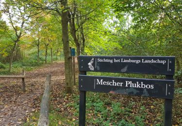
Randonnée Marche de 8,8 km à découvrir à Limbourg, Inconnu, Eijsden-Margraten. Cette randonnée est proposée par mumu.larandonneuse.
Description
Avec ses murs robustes et ses tours impressionnantes, le château Mheer du XIVe siècle est le principal accroche-regard du village. Cependant, si vous continuez à marcher depuis ce village près de Maastricht, vous verrez bien d'autres belles choses sur la route. Qu'en est-il du Hoogbos densément envahi par la végétation, du château belge d'Altenbroek ou de la gracieuse église St. Brigida à Noorbeek ? Tant à Mheer qu'à Noorbeek, vous pouvez bien garer votre voiture et il y a beaucoup de bons restaurants pour déguster une délicieuse tasse de café.
➡️ Vous suivez cet itinéraire pédestre via les poteaux bleus.
ℹ️ www.visitzuidlimburg.fr
Localisation
Commentaires
Randonnées à proximité
![Randonnée Marche Eijsden-Margraten - Gulpen - Hubertusmarkt - Photo](https://media.geolcdn.com/t/375/260/6a2a5595-eb93-4f0f-8c09-6c6ead7a7201.jpg&format=jpg&maxdim=2)
![Marche Marche](https://static1.geolcdn.com/sitytour/trail-icons/101.png)
Marche
![](/images/other/stat-length.png)
![](https://static1.geolcdn.com/siteimages/upload/files/16400158638029165_repeat_loop_refresh_sync_direction_icon.png)
![Randonnée Marche Eijsden-Margraten - Mheer - Banholt - Hoogbos - Photo](https://media.geolcdn.com/t/375/260/1f70cdf1-9a0b-4d25-acc7-7c75993bbb86.jpg&format=jpg&maxdim=2)
![Marche Marche](https://static1.geolcdn.com/sitytour/trail-icons/101.png)
Marche
![](/images/other/stat-length.png)
![](https://static1.geolcdn.com/siteimages/upload/files/16400158638029165_repeat_loop_refresh_sync_direction_icon.png)
![Randonnée Marche Eijsden-Margraten - Eijsden - E8 - Bloesemroute-3 - Photo](https://media.geolcdn.com/t/375/260/7792b7db-95a9-4b53-8cd5-7eae3fedc6a4.jpg&format=jpg&maxdim=2)
![Marche Marche](https://static1.geolcdn.com/sitytour/trail-icons/101.png)
Marche
![](/images/other/stat-length.png)
![](https://static1.geolcdn.com/siteimages/upload/files/16400158638029165_repeat_loop_refresh_sync_direction_icon.png)
![Randonnée Marche Eijsden-Margraten - Mesch [Eijsden - E5] - Photo](https://media.geolcdn.com/t/375/260/cb3c0103-7b73-4049-ab47-8594df511d3c.jpg&format=jpg&maxdim=2)
![Marche Marche](https://static1.geolcdn.com/sitytour/trail-icons/101.png)
Marche
![](/images/other/stat-length.png)
![](https://static1.geolcdn.com/siteimages/upload/files/16400158638029165_repeat_loop_refresh_sync_direction_icon.png)
![Randonnée Marche Fourons - Ulvend - La Planck - Noorbeek - Photo](https://media.geolcdn.com/t/375/260/1b8a3af4-c436-4943-b8e2-3197209c6144.jpg&format=jpg&maxdim=2)
![Marche Marche](https://static1.geolcdn.com/sitytour/trail-icons/101.png)
Marche
![](/images/other/stat-length.png)
![](https://static1.geolcdn.com/siteimages/upload/files/16400158638029165_repeat_loop_refresh_sync_direction_icon.png)
![Randonnée Marche Fourons - Wandelroute-de-voerstreek-mooiste - Photo](https://media.geolcdn.com/t/375/260/3df743f8-88e4-4c10-a47a-c05fdf0072fe.jpg&format=jpg&maxdim=2)
![Marche Marche](https://static1.geolcdn.com/sitytour/trail-icons/101.png)
Marche
![](/images/other/stat-length.png)
![](https://static1.geolcdn.com/siteimages/upload/files/16400158638029165_repeat_loop_refresh_sync_direction_icon.png)
![Randonnée Marche Eijsden-Margraten - Gronsveld_1327 - Photo](https://media.geolcdn.com/t/375/260/877eed2d-204c-4212-a49e-caf4fc574b56.jpg&format=jpg&maxdim=2)
![Marche Marche](https://static1.geolcdn.com/sitytour/trail-icons/101.png)
Marche
![](/images/other/stat-length.png)
![](https://static1.geolcdn.com/siteimages/upload/files/16400158638029165_repeat_loop_refresh_sync_direction_icon.png)
![Randonnée Marche Eijsden-Margraten - E9 - Mesch - Mouland - Photo](https://media.geolcdn.com/t/375/260/44ba086f-f486-4631-8c1f-b562699d8ecb.jpg&format=jpg&maxdim=2)
![Marche Marche](https://static1.geolcdn.com/sitytour/trail-icons/101.png)
Marche
![](/images/other/stat-length.png)
![](https://static1.geolcdn.com/siteimages/upload/files/16400158638029165_repeat_loop_refresh_sync_direction_icon.png)
![Randonnée Marche Eijsden-Margraten - Mesch - Photo](https://media.geolcdn.com/t/375/260/877552c4-bc60-4040-89d8-1feef8999df8.jpg&format=jpg&maxdim=2)
![Marche Marche](https://static1.geolcdn.com/sitytour/trail-icons/101.png)
Marche
![](/images/other/stat-length.png)
![](https://static1.geolcdn.com/siteimages/upload/files/16400158638029165_repeat_loop_refresh_sync_direction_icon.png)