![](/images/other/stat-length.png)
![Randonnée Marche Pau - Pau sud - Bizanos - Photo](https://media.geolcdn.com/t/1900/400/ext.pjpeg?maxdim=2&url=https%3A%2F%2Fstatic1.geolcdn.com%2Fsiteimages%2Fupload%2Ffiles%2F1553511878bg_sport_marche.png)
Pau sud - Bizanos
bedous
Utilisateur
![Longueur](/images/other/stat-length.png)
Longueur
11 km
![Altitude max](https://static1.geolcdn.com/siteimages/upload/files/1508320355ic_sort_altitude_max_24dp.png)
Altitude max
238 m
![Dénivelé positif](https://static1.geolcdn.com/siteimages/upload/files/1508320355ic_sort_den_pos_24dp.png)
Dénivelé positif
143 m
![Km-Effort](/images/other/stat-length.png)
Km-Effort
12,9 km
![Altitude min](https://static1.geolcdn.com/siteimages/upload/files/1508320355ic_sort_altitude_min_24dp.png)
Altitude min
176 m
![Dénivelé négatif](https://static1.geolcdn.com/siteimages/upload/files/1508320355ic_sort_den_neg_24dp.png)
Dénivelé négatif
144 m
![Boucle](https://static1.geolcdn.com/siteimages/upload/files/16400158638029165_repeat_loop_refresh_sync_direction_icon.png)
Boucle
Oui
Date de création :
2024-07-15 08:09:08.881
Dernière modification :
2024-07-15 14:18:44.19
![Marche](https://static1.geolcdn.com/sitytour/trail-icons/101.png)
2h56
Difficulté : Difficile
![Scannez ce code QR pour ouvrir la randonnée dans l'application SityTrail](https://capi.geolives.com/qq0zvz2zws4bq2lad0pu/sitytour/trails/4122735/qr.png?size=200)
Application GPS de randonnée GRATUITE
À propos
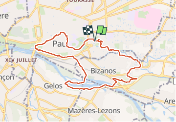
Randonnée Marche de 11 km à découvrir à Nouvelle-Aquitaine, Pyrénées-Atlantiques, Pau. Cette randonnée est proposée par bedous.
Description
Très belle randonnée par sentiers le long de ruisseaux ou du Gave de Pau, au travers de magnifiques parcs ou par de petites voies avec de superbes demeures.
Localisation
Pays :
France
Région :
Nouvelle-Aquitaine
Département/Province :
Pyrénées-Atlantiques
Commune :
Pau
Localité :
Unknown
Départ:(Dec)
Départ:(UTM)
714462 ; 4797114 (30T) N.
Commentaires
Randonnées à proximité
![Randonnée Marche Pau - PAU bois de bastard - Photo](https://media.geolcdn.com/t/375/260/ext.jpg?maxdim=2&url=https%3A%2F%2Fservices.sitytrail.com%2FGeolivesWS%2FDownloadMedia.ashx%3FTrailID%3D888611%26Media%3Dfix__20180116161328.jpg)
![Marche Marche](https://static1.geolcdn.com/sitytour/trail-icons/101.png)
PAU bois de bastard
Marche
Très facile
(1)
Pau,
Nouvelle-Aquitaine,
Pyrénées-Atlantiques,
France
![](/images/other/stat-length.png)
5 km | 5,5 km-effort
1h 54min
![](https://static1.geolcdn.com/siteimages/upload/files/16400158638029165_repeat_loop_refresh_sync_direction_icon.png)
Oui
![Randonnée Marche Rontignon - Coteaux de Rontignon - Photo](https://media.geolcdn.com/t/375/260/ext.jpg?maxdim=2&url=https%3A%2F%2Fservices.sitytrail.com%2FGeolivesWS%2FDownloadMedia.ashx%3FTrailID%3D103073%26Media%3D4763_4.jpg)
![Marche Marche](https://static1.geolcdn.com/sitytour/trail-icons/101.png)
Coteaux de Rontignon
Marche
Moyen
(3)
Rontignon,
Nouvelle-Aquitaine,
Pyrénées-Atlantiques,
France
![](/images/other/stat-length.png)
7,3 km | 10,1 km-effort
1h 45min
![](https://static1.geolcdn.com/siteimages/upload/files/16400158638029165_repeat_loop_refresh_sync_direction_icon.png)
Oui
![Randonnée Marche Idron - Idron golf - Photo](https://media.geolcdn.com/t/375/260/ext.jpg?maxdim=2&url=https%3A%2F%2Fstatic1.geolcdn.com%2Fsiteimages%2Fupload%2Ffiles%2F1553511878bg_sport_marche.png)
![Marche Marche](https://static1.geolcdn.com/sitytour/trail-icons/101.png)
Idron golf
Marche
Très facile
(1)
Idron,
Nouvelle-Aquitaine,
Pyrénées-Atlantiques,
France
![](/images/other/stat-length.png)
3,3 km | 3,6 km-effort
48min
![](https://static1.geolcdn.com/siteimages/upload/files/16400158638029165_repeat_loop_refresh_sync_direction_icon.png)
Oui
![Randonnée Marche Pau - PAU RS entre jardins et villa quartier Trespoey](https://media.geolcdn.com/t/375/260/4ef921b3-2e64-48c5-a483-91dfaca18d96.jpg&format=jpg&maxdim=2)
![Marche Marche](https://static1.geolcdn.com/sitytour/trail-icons/101.png)
PAU RS entre jardins et villa quartier Trespoey "3644386"
Marche
Moyen
Pau,
Nouvelle-Aquitaine,
Pyrénées-Atlantiques,
France
![](/images/other/stat-length.png)
5,5 km | 6,2 km-effort
1h 24min
![](https://static1.geolcdn.com/siteimages/upload/files/16400158638029165_repeat_loop_refresh_sync_direction_icon.png)
Oui
![Randonnée Marche Bizanos - BIZANOS RANDONNÉE PATRIMOINE 2868740 - Photo](https://media.geolcdn.com/t/375/260/213837b0-04be-4f10-8a02-95ffa46e349c.jpg&format=jpg&maxdim=2)
![Marche Marche](https://static1.geolcdn.com/sitytour/trail-icons/101.png)
BIZANOS RANDONNÉE PATRIMOINE 2868740
Marche
Facile
Bizanos,
Nouvelle-Aquitaine,
Pyrénées-Atlantiques,
France
![](/images/other/stat-length.png)
7,6 km | 8,6 km-effort
1h 52min
![](https://static1.geolcdn.com/siteimages/upload/files/16400158638029165_repeat_loop_refresh_sync_direction_icon.png)
Non
![Randonnée Marche Rontignon - RONTIGNON le chemin des crêtes M2 fait 2644181 - Photo](https://media.geolcdn.com/t/375/260/797f6c13-d1f6-445b-af12-f454d456b125.jpg&format=jpg&maxdim=2)
![Marche Marche](https://static1.geolcdn.com/sitytour/trail-icons/101.png)
RONTIGNON le chemin des crêtes M2 fait 2644181
Marche
Facile
Rontignon,
Nouvelle-Aquitaine,
Pyrénées-Atlantiques,
France
![](/images/other/stat-length.png)
8,5 km | 12 km-effort
2h 5min
![](https://static1.geolcdn.com/siteimages/upload/files/16400158638029165_repeat_loop_refresh_sync_direction_icon.png)
Oui
![Randonnée Marche Uzos - UZOS la boucle de la glandee balisee le 29 07 20 - Photo](https://media.geolcdn.com/t/375/260/e45bec67-f808-4c2a-b223-22164fa7db06.jpg&format=jpg&maxdim=2)
![Marche Marche](https://static1.geolcdn.com/sitytour/trail-icons/101.png)
UZOS la boucle de la glandee balisee le 29 07 20
Marche
Moyen
Uzos,
Nouvelle-Aquitaine,
Pyrénées-Atlantiques,
France
![](/images/other/stat-length.png)
13,1 km | 17,3 km-effort
8h 14min
![](https://static1.geolcdn.com/siteimages/upload/files/16400158638029165_repeat_loop_refresh_sync_direction_icon.png)
Oui
![Randonnée Marche Idron - IDRON Deconfinement seul - Photo](https://media.geolcdn.com/t/375/260/c0185c73-9332-4a95-b3e0-d63027a94adb.jpg&format=jpg&maxdim=2)
![Marche Marche](https://static1.geolcdn.com/sitytour/trail-icons/101.png)
IDRON Deconfinement seul
Marche
Moyen
Idron,
Nouvelle-Aquitaine,
Pyrénées-Atlantiques,
France
![](/images/other/stat-length.png)
9,6 km | 11,1 km-effort
2h 8min
![](https://static1.geolcdn.com/siteimages/upload/files/16400158638029165_repeat_loop_refresh_sync_direction_icon.png)
Oui
![Randonnée Marche Idron - IDRON confinement 33 eme - Photo](https://media.geolcdn.com/t/375/260/ec2df528-9a3a-4b62-ac63-ea639520db62.jpg&format=jpg&maxdim=2)
![Marche Marche](https://static1.geolcdn.com/sitytour/trail-icons/101.png)
IDRON confinement 33 eme
Marche
Très facile
Idron,
Nouvelle-Aquitaine,
Pyrénées-Atlantiques,
France
![](/images/other/stat-length.png)
5,9 km | 6,3 km-effort
1h 8min
![](https://static1.geolcdn.com/siteimages/upload/files/16400158638029165_repeat_loop_refresh_sync_direction_icon.png)
Oui