![](/images/other/stat-length.png)
![Randonnée Marche Leucate - Leucate, boucle de la Gardiole - Photo](https://media.geolcdn.com/t/1900/400/ext.pjpeg?maxdim=2&url=https%3A%2F%2Fstatic1.geolcdn.com%2Fsiteimages%2Fupload%2Ffiles%2F1553511878bg_sport_marche.png)
Leucate, boucle de la Gardiole
Santblasi
Utilisateur
![Longueur](/images/other/stat-length.png)
![Altitude max](https://static1.geolcdn.com/siteimages/upload/files/1508320355ic_sort_altitude_max_24dp.png)
![Dénivelé positif](https://static1.geolcdn.com/siteimages/upload/files/1508320355ic_sort_den_pos_24dp.png)
![Km-Effort](/images/other/stat-length.png)
![Altitude min](https://static1.geolcdn.com/siteimages/upload/files/1508320355ic_sort_altitude_min_24dp.png)
![Dénivelé négatif](https://static1.geolcdn.com/siteimages/upload/files/1508320355ic_sort_den_neg_24dp.png)
![Boucle](https://static1.geolcdn.com/siteimages/upload/files/16400158638029165_repeat_loop_refresh_sync_direction_icon.png)
![Marche](https://static1.geolcdn.com/sitytour/trail-icons/101.png)
4h16
Difficulté : Moyen
![Scannez ce code QR pour ouvrir la randonnée dans l'application SityTrail](https://capi.geolives.com/qq0zvz2zws4bq2lad0pu/sitytour/trails/4116866/qr.png?size=200)
Application GPS de randonnée GRATUITE
À propos
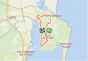
Randonnée Marche de 13,6 km à découvrir à Occitanie, Aude, Leucate. Cette randonnée est proposée par Santblasi.
Description
Départ parking O. Tourisme de Leucate village.
Suivre sentier vignerons puis surveiller tracé et suivre petites routes, chemins carrossables et pistes entre vignes, murets et pinèdes sur plateau calcaire.
Après avoir admiré La Franquie, partir à gauche en direction des étangs. Descendre jusqu'à la piste cyclable et repartir dans les pinèdes.
On termine le long de l'étang avant de grimper et passer visiter le château.
Descente au village et arrivée au parking.
enregistrement resté fermé en bord d'étang sans incidence sur les dénivelés.
2 allé
Localisation
Commentaires
Randonnées à proximité
![Randonnée Marche Leucate - mon sentier des pêcheurs - Photo](https://media.geolcdn.com/t/375/260/d041d0df-07da-4421-a9ea-d982392d3e0c.jpg&format=jpg&maxdim=2)
![Marche Marche](https://static1.geolcdn.com/sitytour/trail-icons/101.png)
Marche
![](/images/other/stat-length.png)
![](https://static1.geolcdn.com/siteimages/upload/files/16400158638029165_repeat_loop_refresh_sync_direction_icon.png)
![Randonnée Marche Leucate - Leucate village - Photo](https://media.geolcdn.com/t/375/260/ext.jpg?maxdim=2&url=https%3A%2F%2Fservices.sitytrail.com%2FGeolivesWS%2FDownloadMedia.ashx%3FTrailID%3D179085%26Media%3Df1524f36-0682-4bf6-975a-882cd23421f5.JPG)
![Marche Marche](https://static1.geolcdn.com/sitytour/trail-icons/101.png)
![Randonnée V.T.T. Leucate - Leucate sur un plateau ! - Photo](https://media.geolcdn.com/t/375/260/ext.jpg?maxdim=2&url=https%3A%2F%2Fservices.sitytrail.com%2FGeolivesWS%2FDownloadMedia.ashx%3FTrailID%3D100672%26Media%3D196_3.jpg)
![V.T.T. V.T.T.](https://static1.geolcdn.com/sitytour/trail-icons/202.png)
V.T.T.
![](/images/other/stat-length.png)
![](https://static1.geolcdn.com/siteimages/upload/files/16400158638029165_repeat_loop_refresh_sync_direction_icon.png)
![Randonnée V.T.T. Leucate - VTT Leucate La Palme - Photo](https://media.geolcdn.com/t/375/260/f6afc4d0-f8dc-4d8d-bdc2-3236cac7bfec.jpg&format=jpg&maxdim=2)
![V.T.T. V.T.T.](https://static1.geolcdn.com/sitytour/trail-icons/202.png)
V.T.T.
![](/images/other/stat-length.png)
![](https://static1.geolcdn.com/siteimages/upload/files/16400158638029165_repeat_loop_refresh_sync_direction_icon.png)
![Randonnée Marche Leucate - Leucate Sentier du guetteur+ château - Photo](https://media.geolcdn.com/t/375/260/0d9f9422-d3ba-4f9e-b0b9-30df507d067c.jpg&format=jpg&maxdim=2)
![Marche Marche](https://static1.geolcdn.com/sitytour/trail-icons/101.png)
Marche
![](/images/other/stat-length.png)
![](https://static1.geolcdn.com/siteimages/upload/files/16400158638029165_repeat_loop_refresh_sync_direction_icon.png)
![Randonnée Marche Leucate - plateau leucate - sud est - Photo](https://media.geolcdn.com/t/375/260/fc551c80-a7a1-459f-83d9-ef8bc94cafd9.jpg&format=jpg&maxdim=2)
![Marche Marche](https://static1.geolcdn.com/sitytour/trail-icons/101.png)
Marche
![](/images/other/stat-length.png)
![](https://static1.geolcdn.com/siteimages/upload/files/16400158638029165_repeat_loop_refresh_sync_direction_icon.png)
![Randonnée Marche Leucate - leucate - cap des frères (sentier des bergers) -la franqui (sentier des guetteurs) - leucate (se tier des vignerons) - Photo](https://media.geolcdn.com/t/375/260/5389bc4c-6ebc-475a-8eed-23be4124a740.jpg&format=jpg&maxdim=2)
![Marche Marche](https://static1.geolcdn.com/sitytour/trail-icons/101.png)
Marche
![](/images/other/stat-length.png)
![](https://static1.geolcdn.com/siteimages/upload/files/16400158638029165_repeat_loop_refresh_sync_direction_icon.png)
![Randonnée Marche Leucate - Leucate-plateau- A/sentier du vigneronx et R/ sentier du berger - Photo](https://media.geolcdn.com/t/375/260/ext.jpg?maxdim=2&url=https%3A%2F%2Fstatic1.geolcdn.com%2Fsiteimages%2Fupload%2Ffiles%2F1553511878bg_sport_marche.png)
![Marche Marche](https://static1.geolcdn.com/sitytour/trail-icons/101.png)
Marche
![](/images/other/stat-length.png)
![](https://static1.geolcdn.com/siteimages/upload/files/16400158638029165_repeat_loop_refresh_sync_direction_icon.png)
![Randonnée Marche Leucate - Leucate château falaise - Photo](https://media.geolcdn.com/t/375/260/3cce4778-81ed-4254-af5e-b0b5f1ccbabf.jpg&format=jpg&maxdim=2)
![Marche Marche](https://static1.geolcdn.com/sitytour/trail-icons/101.png)
Marche
![](/images/other/stat-length.png)
![](https://static1.geolcdn.com/siteimages/upload/files/16400158638029165_repeat_loop_refresh_sync_direction_icon.png)