![](/images/other/stat-length.png)
![Randonnée V.T.C. Yerres - chemin des Roses Reau Sénart - Photo](https://media.geolcdn.com/t/1900/400/f8ba0ac5-2833-4c96-a60f-1699fbd5bc2d.jpg&format=pjpeg&maxdim=2)
chemin des Roses Reau Sénart
Catherine de Brunoy
Utilisateur
![Longueur](/images/other/stat-length.png)
Longueur
62 km
![Altitude max](https://static1.geolcdn.com/siteimages/upload/files/1508320355ic_sort_altitude_max_24dp.png)
Altitude max
102 m
![Dénivelé positif](https://static1.geolcdn.com/siteimages/upload/files/1508320355ic_sort_den_pos_24dp.png)
Dénivelé positif
433 m
![Km-Effort](/images/other/stat-length.png)
Km-Effort
67 km
![Altitude min](https://static1.geolcdn.com/siteimages/upload/files/1508320355ic_sort_altitude_min_24dp.png)
Altitude min
37 m
![Dénivelé négatif](https://static1.geolcdn.com/siteimages/upload/files/1508320355ic_sort_den_neg_24dp.png)
Dénivelé négatif
406 m
![Boucle](https://static1.geolcdn.com/siteimages/upload/files/16400158638029165_repeat_loop_refresh_sync_direction_icon.png)
Boucle
Non
Date de création :
2024-07-09 06:58:30.467
Dernière modification :
2024-07-09 13:43:15.524
![V.T.C.](https://static1.geolcdn.com/sitytour/trail-icons/203.png)
4h08
Difficulté : Très difficile
![Scannez ce code QR pour ouvrir la randonnée dans l'application SityTrail](https://capi.geolives.com/qq0zvz2zws4bq2lad0pu/sitytour/trails/4116648/qr.png?size=200)
Application GPS de randonnée GRATUITE
À propos
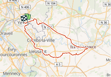
Randonnée V.T.C. de 62 km à découvrir à Île-de-France, Essonne, Yerres. Cette randonnée est proposée par Catherine de Brunoy.
Description
Villecresnes coulée verte chemin des Roses Yebles Reau picnic école retour étangs Lieusaint Tigery Forêt Sénart petit chemin. Christian Pontier
Localisation
Pays :
France
Région :
Île-de-France
Département/Province :
Essonne
Commune :
Yerres
Localité :
Unknown
Départ:(Dec)
Départ:(UTM)
462320 ; 5395718 (31U) N.
Commentaires
Randonnées à proximité
![Randonnée A pied Villecresnes - L 20 boucle golf villecresnes et ancienne voie de chemin de fer - Photo](https://media.geolcdn.com/t/375/260/ext.jpg?maxdim=2&url=https%3A%2F%2Fstatic1.geolcdn.com%2Fsiteimages%2Fupload%2Ffiles%2F1545311037marcheuse_200dpi.jpg)
![A pied A pied](https://static1.geolcdn.com/sitytour/trail-icons/100.png)
L 20 boucle golf villecresnes et ancienne voie de chemin de fer
A pied
Très facile
(6)
Villecresnes,
Île-de-France,
Val-de-Marne,
France
![](/images/other/stat-length.png)
6,5 km | 7,7 km-effort
1h 44min
![](https://static1.geolcdn.com/siteimages/upload/files/16400158638029165_repeat_loop_refresh_sync_direction_icon.png)
Oui
![Randonnée Marche Boussy-Saint-Antoine - GRP CV-IDF 15R Boussy-Saint-Antoine à Juvisy-sur-Orge - Photo](https://media.geolcdn.com/t/375/260/9a88b6b6-acb4-4798-9224-ae0478acaf21.jpg&format=jpg&maxdim=2)
![Marche Marche](https://static1.geolcdn.com/sitytour/trail-icons/101.png)
GRP CV-IDF 15R Boussy-Saint-Antoine à Juvisy-sur-Orge
Marche
Difficile
(1)
Boussy-Saint-Antoine,
Île-de-France,
Essonne,
France
![](/images/other/stat-length.png)
16,8 km | 18,6 km-effort
4h 13min
![](https://static1.geolcdn.com/siteimages/upload/files/16400158638029165_repeat_loop_refresh_sync_direction_icon.png)
Non
![Randonnée Marche Mandres-les-Roses - J 26 Mandres, Boussy , Brunoy le chemin des fresques - Photo](https://media.geolcdn.com/t/375/260/a7099e05-5a69-431c-83ab-49f9701f5dd5.jpg&format=jpg&maxdim=2)
![Marche Marche](https://static1.geolcdn.com/sitytour/trail-icons/101.png)
J 26 Mandres, Boussy , Brunoy le chemin des fresques
Marche
Moyen
(2)
Mandres-les-Roses,
Île-de-France,
Val-de-Marne,
France
![](/images/other/stat-length.png)
12,2 km | 13,8 km-effort
3h 7min
![](https://static1.geolcdn.com/siteimages/upload/files/16400158638029165_repeat_loop_refresh_sync_direction_icon.png)
Oui
![Randonnée Marche Yerres - BM Foret Regionale de Grobois 10km - Photo](https://media.geolcdn.com/t/375/260/ext.jpg?maxdim=2&url=https%3A%2F%2Fstatic1.geolcdn.com%2Fsiteimages%2Fupload%2Ffiles%2F1553511878bg_sport_marche.png)
![Marche Marche](https://static1.geolcdn.com/sitytour/trail-icons/101.png)
BM Foret Regionale de Grobois 10km
Marche
Moyen
(1)
Yerres,
Île-de-France,
Essonne,
France
![](/images/other/stat-length.png)
10,4 km | 11 km-effort
2h 30min
![](https://static1.geolcdn.com/siteimages/upload/files/16400158638029165_repeat_loop_refresh_sync_direction_icon.png)
Oui
![Randonnée Marche Yerres - BM Foret Regionale Grosbois 10km - Photo](https://media.geolcdn.com/t/375/260/ext.jpg?maxdim=2&url=https%3A%2F%2Fstatic1.geolcdn.com%2Fsiteimages%2Fupload%2Ffiles%2F1553511878bg_sport_marche.png)
![Marche Marche](https://static1.geolcdn.com/sitytour/trail-icons/101.png)
BM Foret Regionale Grosbois 10km
Marche
Moyen
(1)
Yerres,
Île-de-France,
Essonne,
France
![](/images/other/stat-length.png)
9,8 km | 10,5 km-effort
2h 23min
![](https://static1.geolcdn.com/siteimages/upload/files/16400158638029165_repeat_loop_refresh_sync_direction_icon.png)
Oui
![Randonnée A pied Brunoy - L 39 Brunoy, les bords de l'Yerres - Photo](https://media.geolcdn.com/t/375/260/ebb13649-b3e9-4bd9-9011-035537427274.jpg&format=jpg&maxdim=2)
![A pied A pied](https://static1.geolcdn.com/sitytour/trail-icons/100.png)
L 39 Brunoy, les bords de l'Yerres
A pied
Très facile
(4)
Brunoy,
Île-de-France,
Essonne,
France
![](/images/other/stat-length.png)
5,4 km | 6,1 km-effort
1h 49min
![](https://static1.geolcdn.com/siteimages/upload/files/16400158638029165_repeat_loop_refresh_sync_direction_icon.png)
Oui
![Randonnée Marche Montgeron - J 38 Montgeron la Pelouse, forêt de Sénart - Photo](https://media.geolcdn.com/t/375/260/f009853b-b232-40f1-8161-c380b5b5f65c.jpg&format=jpg&maxdim=2)
![Marche Marche](https://static1.geolcdn.com/sitytour/trail-icons/101.png)
J 38 Montgeron la Pelouse, forêt de Sénart
Marche
Difficile
(3)
Montgeron,
Île-de-France,
Essonne,
France
![](/images/other/stat-length.png)
12,4 km | 13,3 km-effort
3h 1min
![](https://static1.geolcdn.com/siteimages/upload/files/16400158638029165_repeat_loop_refresh_sync_direction_icon.png)
Oui
![Randonnée A pied Boussy-Saint-Antoine - L 32: Boussy St Antoine l'Yerres et le Gord - Photo](https://media.geolcdn.com/t/375/260/0167f6d8-7862-4a56-9e45-6680bff9395f.jpg&format=jpg&maxdim=2)
![A pied A pied](https://static1.geolcdn.com/sitytour/trail-icons/100.png)
L 32: Boussy St Antoine l'Yerres et le Gord
A pied
Très facile
(3)
Boussy-Saint-Antoine,
Île-de-France,
Essonne,
France
![](/images/other/stat-length.png)
6,2 km | 7,2 km-effort
1h 38min
![](https://static1.geolcdn.com/siteimages/upload/files/16400158638029165_repeat_loop_refresh_sync_direction_icon.png)
Oui
![Randonnée Marche Yerres - J 43 Yerres Parc Caillebotte, île des Prévôts - Photo](https://media.geolcdn.com/t/375/260/3326873b-9942-4059-9e6b-fa272d49fbc4.jpg&format=jpg&maxdim=2)
![Marche Marche](https://static1.geolcdn.com/sitytour/trail-icons/101.png)
J 43 Yerres Parc Caillebotte, île des Prévôts
Marche
Moyen
(4)
Yerres,
Île-de-France,
Essonne,
France
![](/images/other/stat-length.png)
11,4 km | 13,1 km-effort
2h 59min
![](https://static1.geolcdn.com/siteimages/upload/files/16400158638029165_repeat_loop_refresh_sync_direction_icon.png)
Oui