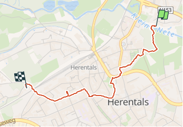
![](/images/other/stat-length.png)
![Randonnée Marche Herentals - Herentals city tour - Photo](https://media.geolcdn.com/t/1900/400/ext.pjpeg?maxdim=2&url=https%3A%2F%2Fstatic1.geolcdn.com%2Fsiteimages%2Fupload%2Ffiles%2F1553511878bg_sport_marche.png)
Herentals city tour
Stefan Wellens
Utilisateur
![Longueur](/images/other/stat-length.png)
Longueur
2,9 km
![Altitude max](https://static1.geolcdn.com/siteimages/upload/files/1508320355ic_sort_altitude_max_24dp.png)
Altitude max
18 m
![Dénivelé positif](https://static1.geolcdn.com/siteimages/upload/files/1508320355ic_sort_den_pos_24dp.png)
Dénivelé positif
12 m
![Km-Effort](/images/other/stat-length.png)
Km-Effort
3,1 km
![Altitude min](https://static1.geolcdn.com/siteimages/upload/files/1508320355ic_sort_altitude_min_24dp.png)
Altitude min
11 m
![Dénivelé négatif](https://static1.geolcdn.com/siteimages/upload/files/1508320355ic_sort_den_neg_24dp.png)
Dénivelé négatif
10 m
![Boucle](https://static1.geolcdn.com/siteimages/upload/files/16400158638029165_repeat_loop_refresh_sync_direction_icon.png)
Boucle
Non
Date de création :
2024-07-07 14:32:54.161
Dernière modification :
2024-07-07 15:31:54.684
![Marche](https://static1.geolcdn.com/sitytour/trail-icons/101.png)
55m
Difficulté : Facile
![Scannez ce code QR pour ouvrir la randonnée dans l'application SityTrail](https://capi.geolives.com/qq0zvz2zws4bq2lad0pu/sitytour/trails/4114770/qr.png?size=200)
Application GPS de randonnée GRATUITE
À propos
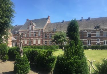
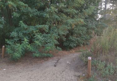
Randonnée Marche de 2,9 km à découvrir à Flandre, Anvers, Herentals. Cette randonnée est proposée par Stefan Wellens.
Description
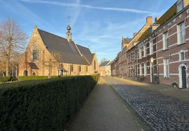
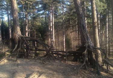
Super romantische gezellige wandeling door groen Herentals langs begijnhof, parkjes, bos, Trollenkoning-troon, Liesjesbos, gezellige terrasjes en leuke wandelwegjes.
Localisation
Pays :
Belgique
Région :
Flandre
Département/Province :
Anvers
Commune :
Herentals
Localité :
Herentals
Départ:(Dec)
Départ:(UTM)
628670 ; 5671959 (31U) N.
Commentaires
Randonnées à proximité
![Randonnée A pied Olen - Dorpkneuterspad - Photo](https://media.geolcdn.com/t/375/260/0a45371b-938c-4d7f-b793-984f73ef576b.jpeg&format=jpg&maxdim=2)
![A pied A pied](https://static1.geolcdn.com/sitytour/trail-icons/100.png)
![Randonnée Marche Vorselaar - Vorselaar Rivier en Bos wandeling - 16 km RT - Photo](https://media.geolcdn.com/t/375/260/ext.jpg?maxdim=2&url=https%3A%2F%2Fstatic1.geolcdn.com%2Fsiteimages%2Fupload%2Ffiles%2F1553511878bg_sport_marche.png)
![Marche Marche](https://static1.geolcdn.com/sitytour/trail-icons/101.png)
Vorselaar Rivier en Bos wandeling - 16 km RT
Marche
Très facile
(1)
Vorselaar,
Flandre,
Anvers,
Belgique
![](/images/other/stat-length.png)
16,5 km | 18 km-effort
Inconnu
![](https://static1.geolcdn.com/siteimages/upload/files/16400158638029165_repeat_loop_refresh_sync_direction_icon.png)
Oui
![Randonnée Marche Herentals - Herentals wandelen tussen groen en monumenten - Photo](https://media.geolcdn.com/t/375/260/ext.jpg?maxdim=2&url=https%3A%2F%2Fstatic1.geolcdn.com%2Fsiteimages%2Fupload%2Ffiles%2F1553511878bg_sport_marche.png)
![Marche Marche](https://static1.geolcdn.com/sitytour/trail-icons/101.png)
Herentals wandelen tussen groen en monumenten
Marche
Moyen
(1)
Herentals,
Flandre,
Anvers,
Belgique
![](/images/other/stat-length.png)
7 km | 7,7 km-effort
1h 42min
![](https://static1.geolcdn.com/siteimages/upload/files/16400158638029165_repeat_loop_refresh_sync_direction_icon.png)
Oui
![Randonnée Marche Herentals - Herentals 24,7 km - Photo](https://media.geolcdn.com/t/375/260/cfc7a163-3260-42ac-912d-8805f7c5a711.jpg&format=jpg&maxdim=2)
![Marche Marche](https://static1.geolcdn.com/sitytour/trail-icons/101.png)
Herentals 24,7 km
Marche
Moyen
Herentals,
Flandre,
Anvers,
Belgique
![](/images/other/stat-length.png)
25 km | 27 km-effort
6h 36min
![](https://static1.geolcdn.com/siteimages/upload/files/16400158638029165_repeat_loop_refresh_sync_direction_icon.png)
Oui
![Randonnée Marche Kasterlee - Lichtaart - Herentals - Lichtaart - Photo](https://media.geolcdn.com/t/375/260/24bf792f-fe8c-4830-86ed-462159e20d6e.jpg&format=jpg&maxdim=2)
![Marche Marche](https://static1.geolcdn.com/sitytour/trail-icons/101.png)
Lichtaart - Herentals - Lichtaart
Marche
Moyen
Kasterlee,
Flandre,
Anvers,
Belgique
![](/images/other/stat-length.png)
13,6 km | 15,4 km-effort
3h 20min
![](https://static1.geolcdn.com/siteimages/upload/files/16400158638029165_repeat_loop_refresh_sync_direction_icon.png)
Oui
![Randonnée Marche Herentals - 31.041 Herentals - Stadswandeling - Photo](https://media.geolcdn.com/t/375/260/bc0c01d4-4dfd-42d3-a540-4a529e1ef104.jpg&format=jpg&maxdim=2)
![Marche Marche](https://static1.geolcdn.com/sitytour/trail-icons/101.png)
31.041 Herentals - Stadswandeling
Marche
Facile
(1)
Herentals,
Flandre,
Anvers,
Belgique
![](/images/other/stat-length.png)
4,5 km | 4,7 km-effort
1h 20min
![](https://static1.geolcdn.com/siteimages/upload/files/16400158638029165_repeat_loop_refresh_sync_direction_icon.png)
Oui
![Randonnée Marche Kasterlee - Kempense Heuvelrug - Photo](https://media.geolcdn.com/t/375/260/ext.jpg?maxdim=2&url=https%3A%2F%2Fstatic1.geolcdn.com%2Fsiteimages%2Fupload%2Ffiles%2F1553511878bg_sport_marche.png)
![Marche Marche](https://static1.geolcdn.com/sitytour/trail-icons/101.png)
Kempense Heuvelrug
Marche
Très facile
Kasterlee,
Flandre,
Anvers,
Belgique
![](/images/other/stat-length.png)
12,4 km | 13,9 km-effort
2h 26min
![](https://static1.geolcdn.com/siteimages/upload/files/16400158638029165_repeat_loop_refresh_sync_direction_icon.png)
Oui
![Randonnée Marche Herentals - boomshakalaka - Photo](https://media.geolcdn.com/t/375/260/435ec1f1-69cb-48f3-9339-7d4e1723dbb9.jpg&format=jpg&maxdim=2)
![Marche Marche](https://static1.geolcdn.com/sitytour/trail-icons/101.png)
![Randonnée Moteur Westerlo - a-belgie-oevel-eifel-lux-ardennen-oevel-2daagse - Photo](https://media.geolcdn.com/t/375/260/ext.jpg?maxdim=2&url=https%3A%2F%2Fstatic1.geolcdn.com%2Fsiteimages%2Fupload%2Ffiles%2F15247431544x4.jpg)
![Moteur Moteur](https://static1.geolcdn.com/sitytour/trail-icons/400.png)
a-belgie-oevel-eifel-lux-ardennen-oevel-2daagse
Moteur
Très facile
Westerlo,
Flandre,
Anvers,
Belgique
![](/images/other/stat-length.png)
599 km | 830 km-effort
Inconnu
![](https://static1.geolcdn.com/siteimages/upload/files/16400158638029165_repeat_loop_refresh_sync_direction_icon.png)
Non