![](/images/other/stat-length.png)
![Randonnée Vélo électrique Pouilly-en-Auxois - Canal de Bourgogne_Etape 5 - Photo](https://media.geolcdn.com/t/1900/400/ext.pjpeg?maxdim=2&url=https%3A%2F%2Fstatic1.geolcdn.com%2Fsiteimages%2Fupload%2Ffiles%2F1524743154velo.jpg)
Canal de Bourgogne_Etape 5
mimi53
Utilisateur
![Longueur](/images/other/stat-length.png)
Longueur
37 km
![Altitude max](https://static1.geolcdn.com/siteimages/upload/files/1508320355ic_sort_altitude_max_24dp.png)
Altitude max
432 m
![Dénivelé positif](https://static1.geolcdn.com/siteimages/upload/files/1508320355ic_sort_den_pos_24dp.png)
Dénivelé positif
204 m
![Km-Effort](/images/other/stat-length.png)
Km-Effort
40 km
![Altitude min](https://static1.geolcdn.com/siteimages/upload/files/1508320355ic_sort_altitude_min_24dp.png)
Altitude min
282 m
![Dénivelé négatif](https://static1.geolcdn.com/siteimages/upload/files/1508320355ic_sort_den_neg_24dp.png)
Dénivelé négatif
302 m
![Boucle](https://static1.geolcdn.com/siteimages/upload/files/16400158638029165_repeat_loop_refresh_sync_direction_icon.png)
Boucle
Non
Date de création :
2024-07-06 21:01:32.969
Dernière modification :
2024-08-13 19:56:54.493
![Vélo électrique](https://static1.geolcdn.com/sitytour/trail-icons/205.png)
0m
Difficulté : Très facile
![Scannez ce code QR pour ouvrir la randonnée dans l'application SityTrail](https://capi.geolives.com/qq0zvz2zws4bq2lad0pu/sitytour/trails/4113965/qr.png?size=200)
Application GPS de randonnée GRATUITE
À propos
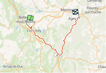
Randonnée Vélo électrique de 37 km à découvrir à Bourgogne-Franche-Comté, Côte-d'Or, Pouilly-en-Auxois. Cette randonnée est proposée par mimi53.
Description
Pouilly en Auxois vers Sainte Marie sur Ouche
Camping super sympa et accueil beaucoup de Vélo
Localisation
Pays :
France
Région :
Bourgogne-Franche-Comté
Département/Province :
Côte-d'Or
Commune :
Pouilly-en-Auxois
Localité :
Unknown
Départ:(Dec)
Départ:(UTM)
617136 ; 5235832 (31T) N.
Commentaires
Randonnées à proximité
![Randonnée Marche Civry-en-Montagne - Civet en montagne - Photo](https://media.geolcdn.com/t/375/260/dd662309-f8c4-4a8d-9db5-5b89765dbfc9.jpg&format=jpg&maxdim=2)
![Marche Marche](https://static1.geolcdn.com/sitytour/trail-icons/101.png)
Civet en montagne
Marche
Civry-en-Montagne,
Bourgogne-Franche-Comté,
Côte-d'Or,
France
![](/images/other/stat-length.png)
10,9 km | 13,9 km-effort
2h 56min
![](https://static1.geolcdn.com/siteimages/upload/files/16400158638029165_repeat_loop_refresh_sync_direction_icon.png)
Oui
![Randonnée Marche Pouilly-en-Auxois - Bourgogne 4L mercredi_backup - Photo](https://media.geolcdn.com/t/375/260/ext.jpg?maxdim=2&url=https%3A%2F%2Fstatic1.geolcdn.com%2Fsiteimages%2Fupload%2Ffiles%2F1553511878bg_sport_marche.png)
![Marche Marche](https://static1.geolcdn.com/sitytour/trail-icons/101.png)
Bourgogne 4L mercredi_backup
Marche
Très facile
(1)
Pouilly-en-Auxois,
Bourgogne-Franche-Comté,
Côte-d'Or,
France
![](/images/other/stat-length.png)
191 km | 240 km-effort
6h 40min
![](https://static1.geolcdn.com/siteimages/upload/files/16400158638029165_repeat_loop_refresh_sync_direction_icon.png)
Oui
![Randonnée Cyclotourisme Pouilly-en-Auxois - Pouilly en Auxois à Fleurey sur Ouche - Photo](https://media.geolcdn.com/t/375/260/3e6bba4d-ea46-4baa-b9f2-8cffb8c7fc4c.jpg&format=jpg&maxdim=2)
![Cyclotourisme Cyclotourisme](https://static1.geolcdn.com/sitytour/trail-icons/204.png)
Pouilly en Auxois à Fleurey sur Ouche
Cyclotourisme
Très difficile
Pouilly-en-Auxois,
Bourgogne-Franche-Comté,
Côte-d'Or,
France
![](/images/other/stat-length.png)
44 km | 47 km-effort
5h 7min
![](https://static1.geolcdn.com/siteimages/upload/files/16400158638029165_repeat_loop_refresh_sync_direction_icon.png)
Non
![Randonnée Marche Bellenot-sous-Pouilly - bellenot - Photo](https://media.geolcdn.com/t/375/260/ext.jpg?maxdim=2&url=https%3A%2F%2Fstatic1.geolcdn.com%2Fsiteimages%2Fupload%2Ffiles%2F1553511878bg_sport_marche.png)
![Marche Marche](https://static1.geolcdn.com/sitytour/trail-icons/101.png)
bellenot
Marche
Facile
Bellenot-sous-Pouilly,
Bourgogne-Franche-Comté,
Côte-d'Or,
France
![](/images/other/stat-length.png)
4 km | 5,5 km-effort
1h 7min
![](https://static1.geolcdn.com/siteimages/upload/files/16400158638029165_repeat_loop_refresh_sync_direction_icon.png)
Oui
![Randonnée Marche Créancey - escommes - Photo](https://media.geolcdn.com/t/375/260/e79d850d-1419-4188-ab76-3aca788cc74c.jpg&format=jpg&maxdim=2)
![Marche Marche](https://static1.geolcdn.com/sitytour/trail-icons/101.png)
escommes
Marche
Facile
Créancey,
Bourgogne-Franche-Comté,
Côte-d'Or,
France
![](/images/other/stat-length.png)
892 m | 938 m-effort
24min
![](https://static1.geolcdn.com/siteimages/upload/files/16400158638029165_repeat_loop_refresh_sync_direction_icon.png)
Non
![Randonnée Marche Pouilly-en-Auxois - 8k-CanalBourgogne - Photo](https://media.geolcdn.com/t/375/260/ext.jpg?maxdim=2&url=https%3A%2F%2Fstatic1.geolcdn.com%2Fsiteimages%2Fupload%2Ffiles%2F1553511878bg_sport_marche.png)
![Marche Marche](https://static1.geolcdn.com/sitytour/trail-icons/101.png)
8k-CanalBourgogne
Marche
Facile
Pouilly-en-Auxois,
Bourgogne-Franche-Comté,
Côte-d'Or,
France
![](/images/other/stat-length.png)
7,7 km | 9,9 km-effort
2h 51min
![](https://static1.geolcdn.com/siteimages/upload/files/16400158638029165_repeat_loop_refresh_sync_direction_icon.png)
Oui
![Randonnée Vélo Pouilly-en-Auxois - Pouilly en Auxois Bussière sur Ouche Château neuf Pouilly en Auxois - Photo](https://media.geolcdn.com/t/375/260/ext.jpg?maxdim=2&url=https%3A%2F%2Fstatic1.geolcdn.com%2Fsiteimages%2Fupload%2Ffiles%2F1524743154velo.jpg)
![Vélo Vélo](https://static1.geolcdn.com/sitytour/trail-icons/200.png)
Pouilly en Auxois Bussière sur Ouche Château neuf Pouilly en Auxois
Vélo
Très facile
Pouilly-en-Auxois,
Bourgogne-Franche-Comté,
Côte-d'Or,
France
![](/images/other/stat-length.png)
45 km | 52 km-effort
3h 6min
![](https://static1.geolcdn.com/siteimages/upload/files/16400158638029165_repeat_loop_refresh_sync_direction_icon.png)
Oui
![Randonnée Vélo Pouilly-en-Auxois - Canal de bourgogne - Photo](https://media.geolcdn.com/t/375/260/ext.jpg?maxdim=2&url=https%3A%2F%2Fstatic1.geolcdn.com%2Fsiteimages%2Fupload%2Ffiles%2F1524743154velo.jpg)
![Vélo Vélo](https://static1.geolcdn.com/sitytour/trail-icons/200.png)
Canal de bourgogne
Vélo
Facile
Pouilly-en-Auxois,
Bourgogne-Franche-Comté,
Côte-d'Or,
France
![](/images/other/stat-length.png)
22 km | 27 km-effort
1h 33min
![](https://static1.geolcdn.com/siteimages/upload/files/16400158638029165_repeat_loop_refresh_sync_direction_icon.png)
Oui
![Randonnée Vélo de route Pouilly-en-Auxois - 13 - Photo](https://media.geolcdn.com/t/375/260/ext.jpg?maxdim=2&url=https%3A%2F%2Fstatic1.geolcdn.com%2Fsiteimages%2Fupload%2Ffiles%2F1524743154velo.jpg)
![Vélo de route Vélo de route](https://static1.geolcdn.com/sitytour/trail-icons/201.png)
13
Vélo de route
Très difficile
Pouilly-en-Auxois,
Bourgogne-Franche-Comté,
Côte-d'Or,
France
![](/images/other/stat-length.png)
55 km | 59 km-effort
13h 5min
![](https://static1.geolcdn.com/siteimages/upload/files/16400158638029165_repeat_loop_refresh_sync_direction_icon.png)
Non