Randonnée Marche Sare - col de lizarrieta et col des 3 bornes - Photo

col de lizarrieta et col des 3 bornes

 henribatut
henribatut

Utilisateur

© OpenStreetMap contributors
Longueur
Longueur
13 km
Altitude max
Altitude max
530 m
Dénivelé positif
Dénivelé positif
412 m
Km-Effort
Km-Effort  
18,5 km
Altitude min
Altitude min
381 m
Dénivelé négatif
Dénivelé négatif
412 m
Boucle
Boucle
Oui
Date de création :
2024-07-03 08:33:03.137
Dernière modification :
2024-07-03 15:35:10.277

(0 Avis)

Marche
Marche
3h45
Difficulté : Difficile

Scannez ce code QR pour ouvrir la randonnée dans l'application SityTrail

Application GPS de randonnée GRATUITE

Logo SityTrail SityTrail

IGN / Instituts géographiques

Télécharger SityTrail sur l'App Store Télécharger SityTrail sur Google Play

Logo SityTrail SityTrail World

Le monde est à vous

Télécharger SityTrail sur l'App Store Télécharger SityTrail sur Google Play Télécharger SityTrail sur Huawei AppGallery

À propos

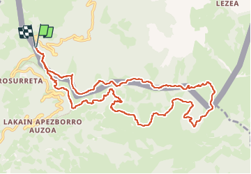
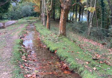
Randonnée Marche de 13 km à découvrir à Nouvelle-Aquitaine, Pyrénées-Atlantiques, Sare. Cette randonnée est proposée par henribatut.

Description

faille 3 juillet avec Maïté
belle rando facile et agréable
possibilité restaurant à la fin

Profil altimétrique

Photos

Localisation

Pays :
France
Région :
Nouvelle-Aquitaine
Département/Province :
Pyrénées-Atlantiques
Commune :
Sare
Localité :
Unknown
Départ:(UTM)
612117 ; 4790691 (30T) N.

Randonnées à proximité

Randonnée A pied Etxalar - SL-NA 5 Argarata - Santa Krutz - Photo
A pied
GUIDE+

A pied

Facile
Etxalar, Navarre, Inconnu, Espagne
4,5 km | 5,7 km-effort
1h 17min
Oui
Randonnée Marche Sare - La rhune par la face EST - Photo
Marche
DECHAMPD

Marche

Moyen
(1)
Sare, Nouvelle-Aquitaine, Pyrénées-Atlantiques, France
13,8 km | 26 km-effort
5h 10min
Oui
Randonnée Marche Sare - sare les palombieres - Photo
Marche
GUIDE
antignacs

Marche

Facile
Sare, Nouvelle-Aquitaine, Pyrénées-Atlantiques, France
15,8 km | 24 km-effort
4h 44min
Oui
Randonnée Marche Sare - atxuria zugaramurdi - Photo
Marche
jcaudron

Marche

Très facile
(3)
Sare, Nouvelle-Aquitaine, Pyrénées-Atlantiques, France
10,3 km | 18,7 km-effort
3h 50min
Oui
Randonnée Marche Sare - Lizarrieta,  Zentinel, col des 3 bornes,  2024 03 04. - Photo
Marche
DECHAMPD

Marche

Difficile
Sare, Nouvelle-Aquitaine, Pyrénées-Atlantiques, France
12,4 km | 17,8 km-effort
4h 3min
Oui
Randonnée Marche Sare - Palombieres ibantelli - Photo
Marche
GUIDE
antignacs

Marche

Facile
Sare, Nouvelle-Aquitaine, Pyrénées-Atlantiques, France
14,8 km | 0 m-effort
5h 6min
Oui
Randonnée Marche Sare - Atxuria tour par zugaramurdi - Photo
Marche
GUIDE
antignacs

Marche

Facile
Sare, Nouvelle-Aquitaine, Pyrénées-Atlantiques, France
14,7 km | 24 km-effort
4h 43min
Oui
Randonnée Marche Sare - Palombieres lizerieta variante  - Photo
Marche
GUIDE
antignacs

Marche

Facile
Sare, Nouvelle-Aquitaine, Pyrénées-Atlantiques, France
16 km | 23 km-effort
5h 13min
Oui
Randonnée Marche Sare - Circuit des trois bornes. Grottes de Sare - Photo
Marche
jaja64

Marche

Très facile
Sare, Nouvelle-Aquitaine, Pyrénées-Atlantiques, France
6,4 km | 11,9 km-effort
2h 50min
Oui


Fermer
Mes abonnements