Randonnée Marche Quarré-les-Tombes - Morvan des 3 lacs - Photo
 Bastet
Bastet

Utilisateur

© OpenStreetMap contributors
Longueur
Longueur
59 km
Altitude max
Altitude max
635 m
Dénivelé positif
Dénivelé positif
1314 m
Km-Effort
Km-Effort  
77 km
Altitude min
Altitude min
276 m
Dénivelé négatif
Dénivelé négatif
1313 m
Boucle
Boucle
Oui
Date de création :
2024-07-03 14:00:34.826
Dernière modification :
2024-07-23 11:53:19.325

(0 Avis)

Marche
Marche
17h25
Difficulté : Très difficile

Scannez ce code QR pour ouvrir la randonnée dans l'application SityTrail

Application GPS de randonnée GRATUITE

Logo SityTrail SityTrail

IGN / Instituts géographiques

Télécharger SityTrail sur l'App Store Télécharger SityTrail sur Google Play

Logo SityTrail SityTrail World

Le monde est à vous

Télécharger SityTrail sur l'App Store Télécharger SityTrail sur Google Play Télécharger SityTrail sur Huawei AppGallery

À propos

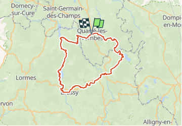
Randonnée Marche de 59 km à découvrir à Bourgogne-Franche-Comté, Yonne, Quarré-les-Tombes. Cette randonnée est proposée par Bastet.

Description

Randonnée à réaliser en 3 ou 4 jours (tranquille) avec deux nuits en bivouac et une au camping. Baignade possible au Lac de St-Agnan

J1 - Km15 Bivouac vers La Pouillouse
J2 - Km 26,3 Camping municipal de Brassy
J3 - Km 46 à 47,5 Bivouac au Lac de St-Agnan

Profil altimétrique

Localisation

Pays :
France
Région :
Bourgogne-Franche-Comté
Département/Province :
Yonne
Commune :
Quarré-les-Tombes
Localité :
Unknown
Départ:(UTM)
575251 ; 5246568 (31T) N.

Randonnées à proximité

Randonnée Marche Marigny-l'Église - Marigny l'Eglise, Chalaux - Photo
Marche
nicolibris

Marche

Moyen
Marigny-l'Église, Bourgogne-Franche-Comté, Nièvre, France
10,7 km | 15 km-effort
3h 20min
Oui
Randonnée Marche Saint-Léger-Vauban - Abbaye-Quarre-Abbaye - Photo
Marche
Yannick89

Marche

Très facile
Saint-Léger-Vauban, Bourgogne-Franche-Comté, Yonne, France
19,2 km | 25 km-effort
5h 12min
Oui
Randonnée Course à pied Saint-Léger-Vauban - la pierre qui vire - Photo
Course à pied
dadodeca

Course à pied

Moyen
Saint-Léger-Vauban, Bourgogne-Franche-Comté, Yonne, France
29 km | 39 km-effort
2h 6min
Non
Randonnée V.T.T. Quarré-les-Tombes - Grande Traversée du Morvan : Quarré les Tombes - Saulieu - Photo
V.T.T.
tracegps

V.T.T.

Difficile
Quarré-les-Tombes, Bourgogne-Franche-Comté, Yonne, France
46 km | 59 km-effort
5h 30min
Non
Randonnée V.T.T. Quarré-les-Tombes - 2 Quarré Saulieu montsauche les Settons 80km 1613m D+ - Photo
V.T.T.
topolino

V.T.T.

Très difficile
Quarré-les-Tombes, Bourgogne-Franche-Comté, Yonne, France
80 km | 101 km-effort
7h 1min
Non
Randonnée V.T.T. Marigny-l'Église - Marigny Saulieu - Photo
V.T.T.
Carnzu

V.T.T.

Très difficile
Marigny-l'Église, Bourgogne-Franche-Comté, Nièvre, France
49 km | 62 km-effort
6h 24min
Non
Randonnée Marche Marigny-l'Église - RIF-04-22-3 du 18.04.2022 - Photo
Marche
bene_dictus77

Marche

Facile
Marigny-l'Église, Bourgogne-Franche-Comté, Nièvre, France
14,9 km | 19,5 km-effort
4h 48min
Non
Randonnée Marche Quarré-les-Tombes - La Cure - Photo
Marche
RAY25

Marche

Très difficile
Quarré-les-Tombes, Bourgogne-Franche-Comté, Yonne, France
19,2 km | 27 km-effort
6h 8min
Oui
Randonnée A pied Saint-Léger-Vauban - St Léger Vauban 22.86 - Photo
A pied
togolo28

A pied

Moyen
Saint-Léger-Vauban, Bourgogne-Franche-Comté, Yonne, France
23 km | 30 km-effort
Inconnu
Oui


Fermer
Mes abonnements