![](/images/other/stat-length.png)
![Randonnée Moto Évette-Salbert - Moto - Evette - Grand Ballon - Nonneck - Lacs de Longemer puis de Gérardmer - chapelle des Vés - Ballon d'Alsace - Photo](https://media.geolcdn.com/t/1900/400/ext.pjpeg?maxdim=2&url=https%3A%2F%2Fmedia.geolcdn.com%2Ff%2F7c4f1884-a1d6-444e-9720-5b0d016b5930.jpg)
Moto - Evette - Grand Ballon - Nonneck - Lacs de Longemer puis de Gérardmer - chapelle des Vés - Ballon d'Alsace
Bart2015
Utilisateur
![Longueur](/images/other/stat-length.png)
Longueur
195 km
![Altitude max](https://static1.geolcdn.com/siteimages/upload/files/1508320355ic_sort_altitude_max_24dp.png)
Altitude max
1339 m
![Dénivelé positif](https://static1.geolcdn.com/siteimages/upload/files/1508320355ic_sort_den_pos_24dp.png)
Dénivelé positif
4277 m
![Km-Effort](/images/other/stat-length.png)
Km-Effort
252 km
![Altitude min](https://static1.geolcdn.com/siteimages/upload/files/1508320355ic_sort_altitude_min_24dp.png)
Altitude min
355 m
![Dénivelé négatif](https://static1.geolcdn.com/siteimages/upload/files/1508320355ic_sort_den_neg_24dp.png)
Dénivelé négatif
4278 m
![Boucle](https://static1.geolcdn.com/siteimages/upload/files/16400158638029165_repeat_loop_refresh_sync_direction_icon.png)
Boucle
Oui
Date de création :
2024-06-27 08:01:13.956
Dernière modification :
2024-06-28 06:35:33.937
![Moto](https://static1.geolcdn.com/sitytour/trail-icons/402.png)
5h39
Difficulté : Difficile
![Scannez ce code QR pour ouvrir la randonnée dans l'application SityTrail](https://capi.geolives.com/qq0zvz2zws4bq2lad0pu/sitytour/trails/4104835/qr.png?size=200)
Application GPS de randonnée GRATUITE
À propos
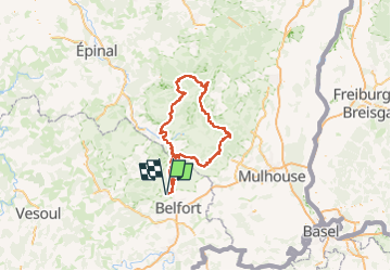
Randonnée Moto de 195 km à découvrir à Bourgogne-Franche-Comté, Territoire-de-Belfort, Évette-Salbert. Cette randonnée est proposée par Bart2015.
Description
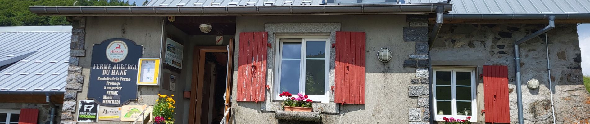
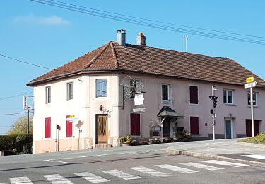
Petite halte à la ferme auberge du Haag : excellent, réservation conseillée.
Bonne balade, soyez prudent ...
Localisation
Pays :
France
Région :
Bourgogne-Franche-Comté
Département/Province :
Territoire-de-Belfort
Commune :
Évette-Salbert
Localité :
Unknown
Départ:(Dec)
Départ:(UTM)
335319 ; 5283234 (32T) N.
Commentaires
Randonnées à proximité
![Randonnée Marche Belfort - Offemont - La ballade des Champs Cerisiers - Photo](https://media.geolcdn.com/t/375/260/ext.jpg?maxdim=2&url=https%3A%2F%2Fstatic1.geolcdn.com%2Fsiteimages%2Fupload%2Ffiles%2F1553511878bg_sport_marche.png)
![Marche Marche](https://static1.geolcdn.com/sitytour/trail-icons/101.png)
Offemont - La ballade des Champs Cerisiers
Marche
Facile
(1)
Belfort,
Bourgogne-Franche-Comté,
Territoire-de-Belfort,
France
![](/images/other/stat-length.png)
8,8 km | 10,8 km-effort
Inconnu
![](https://static1.geolcdn.com/siteimages/upload/files/16400158638029165_repeat_loop_refresh_sync_direction_icon.png)
Oui
![Randonnée Marche Sermamagny - Veronne PC - Photo](https://media.geolcdn.com/t/375/260/ext.jpg?maxdim=2&url=https%3A%2F%2Fstatic1.geolcdn.com%2Fsiteimages%2Fupload%2Ffiles%2F1553511878bg_sport_marche.png)
![Marche Marche](https://static1.geolcdn.com/sitytour/trail-icons/101.png)
Veronne PC
Marche
Très facile
(2)
Sermamagny,
Bourgogne-Franche-Comté,
Territoire-de-Belfort,
France
![](/images/other/stat-length.png)
8,1 km | 9 km-effort
1h 59min
![](https://static1.geolcdn.com/siteimages/upload/files/16400158638029165_repeat_loop_refresh_sync_direction_icon.png)
Oui
![Randonnée Marche Châlonvillars - Châlonvillars - Fort du Salbert - Evette-Salbert - Photo](https://media.geolcdn.com/t/375/260/ext.jpg?maxdim=2&url=https%3A%2F%2Fmedia.geolcdn.com%2Ff%2F30a56d40-1ac0-4227-a497-f489c67ce1fe.jpg)
![Marche Marche](https://static1.geolcdn.com/sitytour/trail-icons/101.png)
Châlonvillars - Fort du Salbert - Evette-Salbert
Marche
Difficile
(1)
Châlonvillars,
Bourgogne-Franche-Comté,
Haute-Saône,
France
![](/images/other/stat-length.png)
11 km | 15,8 km-effort
3h 36min
![](https://static1.geolcdn.com/siteimages/upload/files/16400158638029165_repeat_loop_refresh_sync_direction_icon.png)
Oui
![Randonnée Marche Châlonvillars - Châlonvillars - le mehnir - Mandrevillars - Photo](https://media.geolcdn.com/t/375/260/ext.jpg?maxdim=2&url=https%3A%2F%2Fmedia.geolcdn.com%2Ff%2Fb30d40ec-93d6-4f7b-887c-caef10825b9c.jpg)
![Marche Marche](https://static1.geolcdn.com/sitytour/trail-icons/101.png)
Châlonvillars - le mehnir - Mandrevillars
Marche
Moyen
Châlonvillars,
Bourgogne-Franche-Comté,
Haute-Saône,
France
![](/images/other/stat-length.png)
13,4 km | 17,1 km-effort
2h 39min
![](https://static1.geolcdn.com/siteimages/upload/files/16400158638029165_repeat_loop_refresh_sync_direction_icon.png)
Oui
![Randonnée Marche Châlonvillars - Châlonvillars - Mandrevillars - Photo](https://media.geolcdn.com/t/375/260/ext.jpg?maxdim=2&url=https%3A%2F%2Fmedia.geolcdn.com%2Ff%2Fe4fd3b0e-8b31-475e-ba79-3ca96152b87a.jpg)
![Marche Marche](https://static1.geolcdn.com/sitytour/trail-icons/101.png)
Châlonvillars - Mandrevillars
Marche
Facile
Châlonvillars,
Bourgogne-Franche-Comté,
Haute-Saône,
France
![](/images/other/stat-length.png)
9,5 km | 11,9 km-effort
1h 33min
![](https://static1.geolcdn.com/siteimages/upload/files/16400158638029165_repeat_loop_refresh_sync_direction_icon.png)
Oui
![Randonnée Marche Châlonvillars - Châlonvillars - Mandrevillars par les bois - Photo](https://media.geolcdn.com/t/375/260/ext.jpg?maxdim=2&url=https%3A%2F%2Fmedia.geolcdn.com%2Ff%2Ffcf7d7d5-1c4d-4be5-898e-203e10c38ac6.jpg)
![Marche Marche](https://static1.geolcdn.com/sitytour/trail-icons/101.png)
Châlonvillars - Mandrevillars par les bois
Marche
Facile
Châlonvillars,
Bourgogne-Franche-Comté,
Haute-Saône,
France
![](/images/other/stat-length.png)
10,4 km | 12,9 km-effort
1h 40min
![](https://static1.geolcdn.com/siteimages/upload/files/16400158638029165_repeat_loop_refresh_sync_direction_icon.png)
Oui
![Randonnée Marche Châlonvillars - Châlonvillars - les étangs - fort du Salbert - grottes Cravanche - Photo](https://media.geolcdn.com/t/375/260/ext.jpg?maxdim=2&url=https%3A%2F%2Fmedia.geolcdn.com%2Ff%2F2f213c45-2c85-4a46-8dec-f1e49805b183.jpg)
![Marche Marche](https://static1.geolcdn.com/sitytour/trail-icons/101.png)
Châlonvillars - les étangs - fort du Salbert - grottes Cravanche
Marche
Moyen
Châlonvillars,
Bourgogne-Franche-Comté,
Haute-Saône,
France
![](/images/other/stat-length.png)
13,2 km | 20 km-effort
2h 46min
![](https://static1.geolcdn.com/siteimages/upload/files/16400158638029165_repeat_loop_refresh_sync_direction_icon.png)
Oui
![Randonnée Randonnée équestre Lachapelle-sous-Chaux - Lachapelle-sous-chaux / Planche des belles filles - Photo](https://media.geolcdn.com/t/375/260/ext.jpg?maxdim=2&url=https%3A%2F%2Fstatic1.geolcdn.com%2Fsiteimages%2Fupload%2Ffiles%2F1524743154cheval.jpg)
![Randonnée équestre Randonnée équestre](https://static1.geolcdn.com/sitytour/trail-icons/301.png)
Lachapelle-sous-chaux / Planche des belles filles
Randonnée équestre
Difficile
(1)
Lachapelle-sous-Chaux,
Bourgogne-Franche-Comté,
Territoire-de-Belfort,
France
![](/images/other/stat-length.png)
25 km | 37 km-effort
4h 26min
![](https://static1.geolcdn.com/siteimages/upload/files/16400158638029165_repeat_loop_refresh_sync_direction_icon.png)
Oui
![Randonnée Marche Châlonvillars - Chalonvillars - fort du Salbert - Photo](https://media.geolcdn.com/t/375/260/ext.jpg?maxdim=2&url=https%3A%2F%2Fmedia.geolcdn.com%2Ff%2Fd94b0325-7f77-419f-a66d-33ccd4a2fe00.jpg)
![Marche Marche](https://static1.geolcdn.com/sitytour/trail-icons/101.png)
Chalonvillars - fort du Salbert
Marche
Facile
Châlonvillars,
Bourgogne-Franche-Comté,
Haute-Saône,
France
![](/images/other/stat-length.png)
9,7 km | 14,1 km-effort
2h 27min
![](https://static1.geolcdn.com/siteimages/upload/files/16400158638029165_repeat_loop_refresh_sync_direction_icon.png)
Oui