![](/images/other/stat-length.png)
![Randonnée Marche Boeschepe - Bois de la source - Photo](https://media.geolcdn.com/t/1900/400/f5446731-64f0-4376-b26e-f68e8df60d24.jpg&format=pjpeg&maxdim=2)
Bois de la source
Greg813
Utilisateur
![Longueur](/images/other/stat-length.png)
Longueur
7,6 km
![Altitude max](https://static1.geolcdn.com/siteimages/upload/files/1508320355ic_sort_altitude_max_24dp.png)
Altitude max
131 m
![Dénivelé positif](https://static1.geolcdn.com/siteimages/upload/files/1508320355ic_sort_den_pos_24dp.png)
Dénivelé positif
148 m
![Km-Effort](/images/other/stat-length.png)
Km-Effort
9,6 km
![Altitude min](https://static1.geolcdn.com/siteimages/upload/files/1508320355ic_sort_altitude_min_24dp.png)
Altitude min
49 m
![Dénivelé négatif](https://static1.geolcdn.com/siteimages/upload/files/1508320355ic_sort_den_neg_24dp.png)
Dénivelé négatif
148 m
![Boucle](https://static1.geolcdn.com/siteimages/upload/files/16400158638029165_repeat_loop_refresh_sync_direction_icon.png)
Boucle
Oui
Date de création :
2024-06-23 14:14:23.111
Dernière modification :
2024-06-25 19:33:00.661
![Marche](https://static1.geolcdn.com/sitytour/trail-icons/101.png)
1h26
Difficulté : Facile
![Scannez ce code QR pour ouvrir la randonnée dans l'application SityTrail](https://capi.geolives.com/qq0zvz2zws4bq2lad0pu/sitytour/trails/4100789/qr.png?size=200)
Application GPS de randonnée GRATUITE
À propos
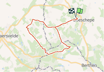
Randonnée Marche de 7,6 km à découvrir à Hauts-de-France, Nord, Boeschepe. Cette randonnée est proposée par Greg813.
Description
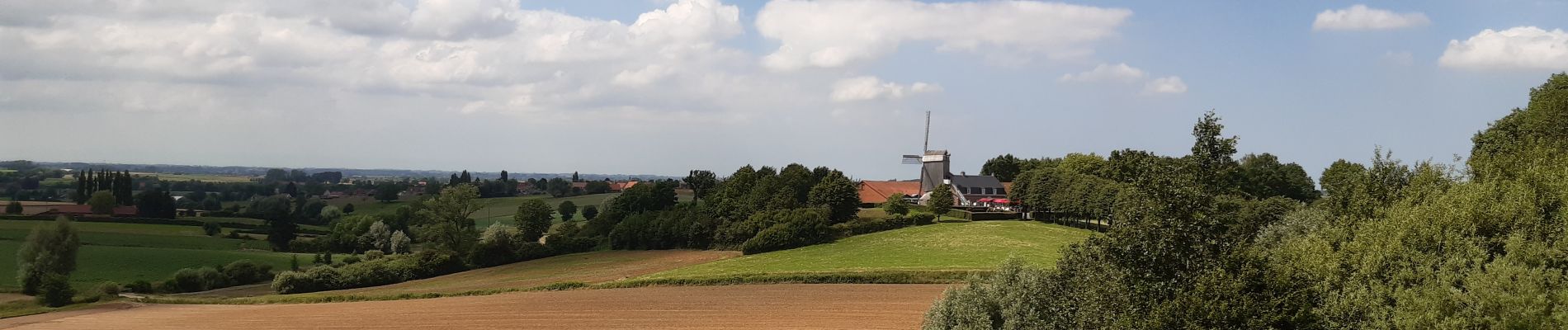
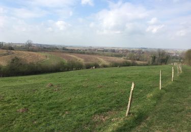
Petite randonnée dans les Monts de Flandres depuis le Moulin de l'Ingratitude et le Mont de Boeschepe au travers du bois de la source.
Localisation
Pays :
France
Région :
Hauts-de-France
Département/Province :
Nord
Commune :
Boeschepe
Localité :
Unknown
Départ:(Dec)
Départ:(UTM)
477932 ; 5627759 (31U) N.
Commentaires
Randonnées à proximité
![Randonnée Marche Heuvelland - Monts Rouge et Noir - Photo](https://media.geolcdn.com/t/375/260/00f0cdf9-629e-4b2f-b8bc-5c314a6f710b.jpg&format=jpg&maxdim=2)
![Marche Marche](https://static1.geolcdn.com/sitytour/trail-icons/101.png)
Monts Rouge et Noir
Marche
Difficile
(1)
Heuvelland,
Flandre,
Flandre-Occidentale,
Belgique
![](/images/other/stat-length.png)
24 km | 30 km-effort
5h 27min
![](https://static1.geolcdn.com/siteimages/upload/files/16400158638029165_repeat_loop_refresh_sync_direction_icon.png)
Oui
![Randonnée Marche Berthen - Autour du monastère - Godewaersvelde - Photo](https://media.geolcdn.com/t/375/260/ext.jpg?maxdim=2&url=https%3A%2F%2Fservices.sitytrail.com%2FGeolivesWS%2FDownloadMedia.ashx%3FTrailID%3D111182%26Media%3D6625_1.jpg)
![Marche Marche](https://static1.geolcdn.com/sitytour/trail-icons/101.png)
Autour du monastère - Godewaersvelde
Marche
Difficile
(4)
Berthen,
Hauts-de-France,
Nord,
France
![](/images/other/stat-length.png)
11,8 km | 15,6 km-effort
3h 0min
![](https://static1.geolcdn.com/siteimages/upload/files/16400158638029165_repeat_loop_refresh_sync_direction_icon.png)
Oui
![Randonnée A pied Heuvelland - Tweebergen wandelroute - Photo](https://media.geolcdn.com/t/375/260/5ebabc26-e95b-4a58-8ae1-ac851bf88f60.jpeg&format=jpg&maxdim=2)
![A pied A pied](https://static1.geolcdn.com/sitytour/trail-icons/100.png)
Tweebergen wandelroute
A pied
Facile
Heuvelland,
Flandre,
Flandre-Occidentale,
Belgique
![](/images/other/stat-length.png)
7,3 km | 9 km-effort
2h 2min
![](https://static1.geolcdn.com/siteimages/upload/files/16400158638029165_repeat_loop_refresh_sync_direction_icon.png)
Oui
![Randonnée Marche Heuvelland - Westouter langs tweetermen - Photo](https://media.geolcdn.com/t/375/260/ext.jpg?maxdim=2&url=https%3A%2F%2Fstatic1.geolcdn.com%2Fsiteimages%2Fupload%2Ffiles%2F1553511878bg_sport_marche.png)
![Marche Marche](https://static1.geolcdn.com/sitytour/trail-icons/101.png)
Westouter langs tweetermen
Marche
Difficile
(1)
Heuvelland,
Flandre,
Flandre-Occidentale,
Belgique
![](/images/other/stat-length.png)
7,5 km | 9,1 km-effort
2h 4min
![](https://static1.geolcdn.com/siteimages/upload/files/16400158638029165_repeat_loop_refresh_sync_direction_icon.png)
Oui
![Randonnée Marche Saint-Jans-Cappel - sentier des jacynthes - Photo](https://media.geolcdn.com/t/375/260/ext.jpg?maxdim=2&url=https%3A%2F%2Fstatic1.geolcdn.com%2Fsiteimages%2Fupload%2Ffiles%2F1553511878bg_sport_marche.png)
![Marche Marche](https://static1.geolcdn.com/sitytour/trail-icons/101.png)
sentier des jacynthes
Marche
Moyen
(1)
Saint-Jans-Cappel,
Hauts-de-France,
Nord,
France
![](/images/other/stat-length.png)
7,3 km | 9,2 km-effort
2h 1min
![](https://static1.geolcdn.com/siteimages/upload/files/16400158638029165_repeat_loop_refresh_sync_direction_icon.png)
Oui
![Randonnée Marche Bailleul - camping de la Ferme des Saules à côté de Bailleul, arrivée Deulemont - Photo](https://media.geolcdn.com/t/375/260/5dfd3b71-bc9e-42e1-b3be-5ab9c2cf49ac.jpg&format=jpg&maxdim=2)
![Marche Marche](https://static1.geolcdn.com/sitytour/trail-icons/101.png)
camping de la Ferme des Saules à côté de Bailleul, arrivée Deulemont
Marche
Moyen
Bailleul,
Hauts-de-France,
Nord,
France
![](/images/other/stat-length.png)
32 km | 34 km-effort
9h 10min
![](https://static1.geolcdn.com/siteimages/upload/files/16400158638029165_repeat_loop_refresh_sync_direction_icon.png)
Non
![Randonnée Marche Boeschepe - Boeschepe - Photo](https://media.geolcdn.com/t/375/260/6c0906d5-5117-4202-927a-8c802fc11963.jpg&format=jpg&maxdim=2)
![Marche Marche](https://static1.geolcdn.com/sitytour/trail-icons/101.png)
Boeschepe
Marche
Difficile
Boeschepe,
Hauts-de-France,
Nord,
France
![](/images/other/stat-length.png)
10,6 km | 13 km-effort
2h 26min
![](https://static1.geolcdn.com/siteimages/upload/files/16400158638029165_repeat_loop_refresh_sync_direction_icon.png)
Non
![Randonnée A pied Poperinge - Helleketelbos - Photo](https://media.geolcdn.com/t/375/260/0c8cf86c-730c-4042-b9e4-e508bb684d2d.jpeg&format=jpg&maxdim=2)
![A pied A pied](https://static1.geolcdn.com/sitytour/trail-icons/100.png)
Helleketelbos
A pied
Facile
Poperinge,
Flandre,
Flandre-Occidentale,
Belgique
![](/images/other/stat-length.png)
10,8 km | 12,5 km-effort
2h 49min
![](https://static1.geolcdn.com/siteimages/upload/files/16400158638029165_repeat_loop_refresh_sync_direction_icon.png)
Oui
![Randonnée Marche Heuvelland - Heuvelland - Photo](https://media.geolcdn.com/t/375/260/0c6f33de-c231-4c4c-850c-8a6cf071ee99.jpg&format=jpg&maxdim=2)
![Marche Marche](https://static1.geolcdn.com/sitytour/trail-icons/101.png)
Heuvelland
Marche
Heuvelland,
Flandre,
Flandre-Occidentale,
Belgique
![](/images/other/stat-length.png)
10,5 km | 12,8 km-effort
3h 10min
![](https://static1.geolcdn.com/siteimages/upload/files/16400158638029165_repeat_loop_refresh_sync_direction_icon.png)
Oui