Randonnée Moto-cross Lanuéjols - recos rando 22 juin - Photo

recos rando 22 juin

© OpenStreetMap contributors
Longueur
Longueur
103 km
Altitude max
Altitude max
1486 m
Dénivelé positif
Dénivelé positif
3158 m
Km-Effort
Km-Effort  
145 km
Altitude min
Altitude min
573 m
Dénivelé négatif
Dénivelé négatif
3157 m
Boucle
Boucle
Oui
Date de création :
2024-06-22 07:12:24.886
Dernière modification :
2024-06-22 12:53:01.659

(0 Avis)

Moto-cross
Moto-cross
5h31
Difficulté : Facile

Scannez ce code QR pour ouvrir la randonnée dans l'application SityTrail

Application GPS de randonnée GRATUITE

Logo SityTrail SityTrail

IGN / Instituts géographiques

Télécharger SityTrail sur l'App Store Télécharger SityTrail sur Google Play

Logo SityTrail SityTrail World

Le monde est à vous

Télécharger SityTrail sur l'App Store Télécharger SityTrail sur Google Play Télécharger SityTrail sur Huawei AppGallery

À propos

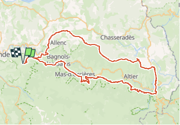
Randonnée Moto-cross de 103 km à découvrir à Occitanie, Lozère, Lanuéjols. Cette randonnée est proposée par lauz'oustal Restaurant chambres d'hôtes.

Profil altimétrique

Localisation

Pays :
France
Région :
Occitanie
Département/Province :
Lozère
Commune :
Lanuéjols
Localité :
Unknown
Départ:(UTM)
545005 ; 4927555 (31T) N.

Randonnées à proximité

Randonnée Marche Badaroux - Pelgeires,le Born la Rouviere  - Photo
Marche
tyntyn

Marche

Moyen
Badaroux, Occitanie, Lozère, France
12,5 km | 18,1 km-effort
3h 6min
Oui
Randonnée Marche Sainte-Hélène - mardi - Photo
Marche
olivier78000

Marche

Très facile
Sainte-Hélène, Occitanie, Lozère, France
12,9 km | 17,7 km-effort
3h 53min
Non
Randonnée Marche Saint-Étienne-du-Valdonnez - gorges du Bramont - Photo
Marche
thomas.o.vert

Marche

Moyen
Saint-Étienne-du-Valdonnez, Occitanie, Lozère, France
10 km | 14,8 km-effort
3h 40min
Oui
Randonnée Marche Lanuéjols - Château de Chapieu - Photo
Marche
jgiraud

Marche

Facile
Lanuéjols, Occitanie, Lozère, France
6,6 km | 9,3 km-effort
2h 44min
Oui
Randonnée Marche  - Vareilles /  Barrandon  - Photo
Marche
tyntyn

Marche

Moyen
, Occitanie, Lozère, France
14 km | 21 km-effort
4h 44min
Oui
Randonnée Marche Brenoux - langlade /Balduc - Photo
Marche
tyntyn

Marche

Moyen
Brenoux, Occitanie, Lozère, France
8,8 km | 13,8 km-effort
2h 50min
Oui
Randonnée Marche Brenoux - Langlade - Photo
Marche
tyntyn

Marche

Facile
Brenoux, Occitanie, Lozère, France
12 km | 16,7 km-effort
3h 6min
Oui
Randonnée Marche Mende - chanteperdrix - Photo
Marche
tyntyn

Marche

Très difficile
Mende, Occitanie, Lozère, France
14,6 km | 20 km-effort
3h 24min
Oui
Randonnée V.T.T. Saint-Bauzile - aerodrome masseguin alle retaur - Photo
V.T.T.
tyntyn

V.T.T.

Moyen
Saint-Bauzile, Occitanie, Lozère, France
23 km | 29 km-effort
2h 0min
Oui


Fermer
Mes abonnements