![](/images/other/stat-length.png)
![Randonnée V.T.C. Moret-Loing-et-Orvanne - Musée Antoine Bourdelle - Photo](https://media.geolcdn.com/t/1900/400/ext.pjpeg?maxdim=2&url=https%3A%2F%2Fmedia.geolcdn.com%2Ff%2F6ceefb99-314b-4005-9863-b58b9d239844.jpg)
Musée Antoine Bourdelle
Catherine de Brunoy
Utilisateur
![Longueur](/images/other/stat-length.png)
Longueur
55 km
![Altitude max](https://static1.geolcdn.com/siteimages/upload/files/1508320355ic_sort_altitude_max_24dp.png)
Altitude max
136 m
![Dénivelé positif](https://static1.geolcdn.com/siteimages/upload/files/1508320355ic_sort_den_pos_24dp.png)
Dénivelé positif
457 m
![Km-Effort](/images/other/stat-length.png)
Km-Effort
61 km
![Altitude min](https://static1.geolcdn.com/siteimages/upload/files/1508320355ic_sort_altitude_min_24dp.png)
Altitude min
46 m
![Dénivelé négatif](https://static1.geolcdn.com/siteimages/upload/files/1508320355ic_sort_den_neg_24dp.png)
Dénivelé négatif
463 m
![Boucle](https://static1.geolcdn.com/siteimages/upload/files/16400158638029165_repeat_loop_refresh_sync_direction_icon.png)
Boucle
Non
Date de création :
2024-06-19 08:10:40.641
Dernière modification :
2024-06-21 22:00:01.153
![V.T.C.](https://static1.geolcdn.com/sitytour/trail-icons/203.png)
3h44
Difficulté : Très difficile
![Scannez ce code QR pour ouvrir la randonnée dans l'application SityTrail](https://capi.geolives.com/qq0zvz2zws4bq2lad0pu/sitytour/trails/4098726/qr.png?size=200)
Application GPS de randonnée GRATUITE
À propos
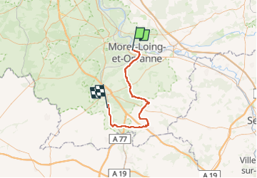
Randonnée V.T.C. de 55 km à découvrir à Île-de-France, Seine-et-Marne, Moret-Loing-et-Orvanne. Cette randonnée est proposée par Catherine de Brunoy.
Description
Moret sur Loing Egreville Bagneaux sur Loing par petite route jolis villages fleuris champs peu de montées 9h00 Yerres RER 17H30 Bagneaux
Localisation
Pays :
France
Région :
Île-de-France
Département/Province :
Seine-et-Marne
Commune :
Moret-Loing-et-Orvanne
Localité :
Veneux-les-Sablons
Départ:(Dec)
Départ:(UTM)
485162 ; 5358356 (31U) N.
Commentaires
Randonnées à proximité
![Randonnée Marche Champagne-sur-Seine - GLM-150507 - Champagne - Photo](https://media.geolcdn.com/t/375/260/ext.jpg?maxdim=2&url=https%3A%2F%2Fservices.sitytrail.com%2FGeolivesWS%2FDownloadMedia.ashx%3FTrailID%3D417747%26Media%3Dcf3441e3-cd65-4b43-a868-e5ea57f18914.jpg)
![Marche Marche](https://static1.geolcdn.com/sitytour/trail-icons/101.png)
GLM-150507 - Champagne
Marche
Facile
(1)
Champagne-sur-Seine,
Île-de-France,
Seine-et-Marne,
France
![](/images/other/stat-length.png)
17,3 km | 20 km-effort
4h 20min
![](https://static1.geolcdn.com/siteimages/upload/files/16400158638029165_repeat_loop_refresh_sync_direction_icon.png)
Oui
![Randonnée Marche Fontainebleau - viennes carosses - Photo](https://media.geolcdn.com/t/375/260/ext.jpg?maxdim=2&url=https%3A%2F%2Fmedia.geolcdn.com%2Ff%2F9b54e644-4214-4411-b7b4-ea5a49e11005.jpg)
![Marche Marche](https://static1.geolcdn.com/sitytour/trail-icons/101.png)
viennes carosses
Marche
Très facile
(2)
Fontainebleau,
Île-de-France,
Seine-et-Marne,
France
![](/images/other/stat-length.png)
10,8 km | 14 km-effort
2h 50min
![](https://static1.geolcdn.com/siteimages/upload/files/16400158638029165_repeat_loop_refresh_sync_direction_icon.png)
Oui
![Randonnée Autre activité Thomery - forêt de fontainebleau - Photo](https://media.geolcdn.com/t/375/260/ext.jpg?maxdim=2&url=https%3A%2F%2Fservices.sitytrail.com%2FGeolivesWS%2FDownloadMedia.ashx%3FTrailID%3D703736%26Media%3D20170223103030.jpg)
![Autre activité Autre activité](https://static1.geolcdn.com/sitytour/trail-icons/900.png)
forêt de fontainebleau
Autre activité
Moyen
(1)
Thomery,
Île-de-France,
Seine-et-Marne,
France
![](/images/other/stat-length.png)
20 km | 23 km-effort
5h 40min
![](https://static1.geolcdn.com/siteimages/upload/files/16400158638029165_repeat_loop_refresh_sync_direction_icon.png)
Oui
![Randonnée A pied Saint-Mammès - Batellerie et foret - Photo](https://media.geolcdn.com/t/375/260/ext.jpg?maxdim=2&url=https%3A%2F%2Fmedia.geolcdn.com%2Ff%2F51b649c2-1598-47b6-9a5e-d0492e6f7a35.jpeg)
![A pied A pied](https://static1.geolcdn.com/sitytour/trail-icons/100.png)
Batellerie et foret
A pied
Facile
Saint-Mammès,
Île-de-France,
Seine-et-Marne,
France
![](/images/other/stat-length.png)
8,6 km | 9,9 km-effort
2h 14min
![](https://static1.geolcdn.com/siteimages/upload/files/16400158638029165_repeat_loop_refresh_sync_direction_icon.png)
Oui
![Randonnée A pied Montigny-sur-Loing - De Kosciusko à Croc Marin - Photo](https://media.geolcdn.com/t/375/260/ext.jpg?maxdim=2&url=https%3A%2F%2Fmedia.geolcdn.com%2Ff%2Ff5bc045f-e010-4cc1-a4ef-a06cb0f8d565.jpeg)
![A pied A pied](https://static1.geolcdn.com/sitytour/trail-icons/100.png)
De Kosciusko à Croc Marin
A pied
Moyen
Montigny-sur-Loing,
Île-de-France,
Seine-et-Marne,
France
![](/images/other/stat-length.png)
17,5 km | 21 km-effort
4h 42min
![](https://static1.geolcdn.com/siteimages/upload/files/16400158638029165_repeat_loop_refresh_sync_direction_icon.png)
Oui
![Randonnée A pied Moret-Loing-et-Orvanne - FR-PR 9 - Photo](https://media.geolcdn.com/t/375/260/ext.jpg?maxdim=2&url=https%3A%2F%2Fmedia.geolcdn.com%2Ff%2F1bc3aed3-626a-45b7-9c5f-13d7fffcd74b.jpeg)
![A pied A pied](https://static1.geolcdn.com/sitytour/trail-icons/100.png)
FR-PR 9
A pied
Facile
Moret-Loing-et-Orvanne,
Île-de-France,
Seine-et-Marne,
France
![](/images/other/stat-length.png)
5 km | 6 km-effort
1h 22min
![](https://static1.geolcdn.com/siteimages/upload/files/16400158638029165_repeat_loop_refresh_sync_direction_icon.png)
Non
![Randonnée A pied Moret-Loing-et-Orvanne - Entre Loing et Orvanne - Photo](https://media.geolcdn.com/t/375/260/ext.jpg?maxdim=2&url=https%3A%2F%2Fmedia.geolcdn.com%2Ff%2F03f6f91d-f2c6-4c29-98db-41cd58cd4804.jpeg)
![A pied A pied](https://static1.geolcdn.com/sitytour/trail-icons/100.png)
Entre Loing et Orvanne
A pied
Facile
Moret-Loing-et-Orvanne,
Île-de-France,
Seine-et-Marne,
France
![](/images/other/stat-length.png)
12,8 km | 15,1 km-effort
3h 26min
![](https://static1.geolcdn.com/siteimages/upload/files/16400158638029165_repeat_loop_refresh_sync_direction_icon.png)
Non
![Randonnée A pied Thomery - JC 56 Fontainebleau, Thomery, la Malmontagne - Photo](https://media.geolcdn.com/t/375/260/ext.jpg?maxdim=2&url=https%3A%2F%2Fstatic1.geolcdn.com%2Fsiteimages%2Fupload%2Ffiles%2F1545311037marcheuse_200dpi.jpg)
![A pied A pied](https://static1.geolcdn.com/sitytour/trail-icons/100.png)
JC 56 Fontainebleau, Thomery, la Malmontagne
A pied
Difficile
(1)
Thomery,
Île-de-France,
Seine-et-Marne,
France
![](/images/other/stat-length.png)
25 km | 30 km-effort
6h 18min
![](https://static1.geolcdn.com/siteimages/upload/files/16400158638029165_repeat_loop_refresh_sync_direction_icon.png)
Oui
![Randonnée Marche Fontainebleau - JC 89 - 22 km - Fontainebleau Rochers d'Avon et Long Rocher - 28 km effort - Photo](https://media.geolcdn.com/t/375/260/ext.jpg?maxdim=2&url=https%3A%2F%2Fstatic1.geolcdn.com%2Fsiteimages%2Fupload%2Ffiles%2F1553511878bg_sport_marche.png)
![Marche Marche](https://static1.geolcdn.com/sitytour/trail-icons/101.png)
JC 89 - 22 km - Fontainebleau Rochers d'Avon et Long Rocher - 28 km effort
Marche
Difficile
(4)
Fontainebleau,
Île-de-France,
Seine-et-Marne,
France
![](/images/other/stat-length.png)
22 km | 27 km-effort
6h 10min
![](https://static1.geolcdn.com/siteimages/upload/files/16400158638029165_repeat_loop_refresh_sync_direction_icon.png)
Oui