![](/images/other/stat-length.png)
![Randonnée Marche Boulaide - Boulaide_sentier-local-bl-4 - Photo](https://media.geolcdn.com/t/1900/400/ext.pjpeg?maxdim=2&url=https%3A%2F%2Fstatic1.geolcdn.com%2Fsiteimages%2Fupload%2Ffiles%2F1553511878bg_sport_marche.png)
Boulaide_sentier-local-bl-4
mumu.larandonneuse
Utilisateur GUIDE
![Longueur](/images/other/stat-length.png)
Longueur
7,7 km
![Altitude max](https://static1.geolcdn.com/siteimages/upload/files/1508320355ic_sort_altitude_max_24dp.png)
Altitude max
464 m
![Dénivelé positif](https://static1.geolcdn.com/siteimages/upload/files/1508320355ic_sort_den_pos_24dp.png)
Dénivelé positif
223 m
![Km-Effort](/images/other/stat-length.png)
Km-Effort
10,6 km
![Altitude min](https://static1.geolcdn.com/siteimages/upload/files/1508320355ic_sort_altitude_min_24dp.png)
Altitude min
323 m
![Dénivelé négatif](https://static1.geolcdn.com/siteimages/upload/files/1508320355ic_sort_den_neg_24dp.png)
Dénivelé négatif
226 m
![Boucle](https://static1.geolcdn.com/siteimages/upload/files/16400158638029165_repeat_loop_refresh_sync_direction_icon.png)
Boucle
Oui
Date de création :
2024-06-17 14:39:23.683
Dernière modification :
2024-06-17 14:42:26.792
![Marche](https://static1.geolcdn.com/sitytour/trail-icons/101.png)
2h25
Difficulté : Moyen
![Scannez ce code QR pour ouvrir la randonnée dans l'application SityTrail](https://capi.geolives.com/qq0zvz2zws4bq2lad0pu/sitytour/trails/4093993/qr.png?size=200)
Application GPS de randonnée GRATUITE
À propos
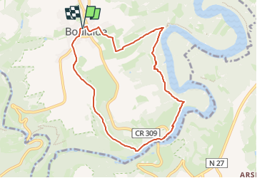
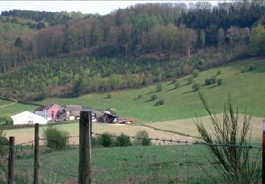
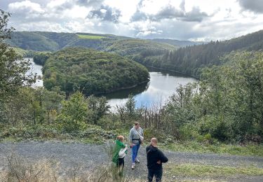
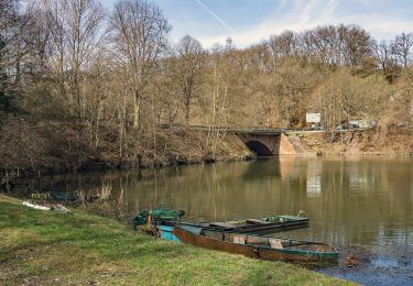
Randonnée Marche de 7,7 km à découvrir à Inconnu, Canton Wiltz, Boulaide. Cette randonnée est proposée par mumu.larandonneuse.
Description
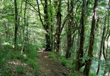
Le sentier de randonnée est balisé dans les deux sens. Veuillez suivre le balisage blanc et bleu "BL 4"
Un parking est situé directement au point de départ.
.
Localisation
Pays :
Luxembourg
Région :
Inconnu
Département/Province :
Canton Wiltz
Commune :
Boulaide
Localité :
Unknown
Départ:(Dec)
Départ:(UTM)
702160 ; 5529907 (31U) N.
Commentaires
Randonnées à proximité
![Randonnée Marche Boulaide - Eislek-pad-Boulaide - Photo](https://media.geolcdn.com/t/375/260/041c5b4a-4ac5-47e8-bcbc-f52e3e2035b5.jpg&format=jpg&maxdim=2)
![Marche Marche](https://static1.geolcdn.com/sitytour/trail-icons/101.png)
Eislek-pad-Boulaide
Marche
Difficile
(1)
Boulaide,
Inconnu,
Canton Wiltz,
Luxembourg
![](/images/other/stat-length.png)
11,5 km | 16,7 km-effort
3h 48min
![](https://static1.geolcdn.com/siteimages/upload/files/16400158638029165_repeat_loop_refresh_sync_direction_icon.png)
Oui
![Randonnée Marche Lac de la Haute-Sûre - Èislek pad Bavigne - Photo](https://media.geolcdn.com/t/375/260/8655d70a-7ba8-450f-9e74-dba2017ba924.jpg&format=jpg&maxdim=2)
![Marche Marche](https://static1.geolcdn.com/sitytour/trail-icons/101.png)
Èislek pad Bavigne
Marche
Moyen
(1)
Lac de la Haute-Sûre,
Inconnu,
Canton Wiltz,
Luxembourg
![](/images/other/stat-length.png)
9,9 km | 13,9 km-effort
3h 9min
![](https://static1.geolcdn.com/siteimages/upload/files/16400158638029165_repeat_loop_refresh_sync_direction_icon.png)
Oui
![Randonnée Marche Fauvillers - RB-Lu-09_Tintange_via-racc-1 - Photo](https://media.geolcdn.com/t/375/260/ext.jpg?maxdim=2&url=https%3A%2F%2Fservices.sitytrail.com%2FGeolivesWS%2FDownloadMedia.ashx%3FTrailID%3D216069%26Media%3D105786c2-6d26-4426-a9ef-a247bd4ac1da.jpg)
![Marche Marche](https://static1.geolcdn.com/sitytour/trail-icons/101.png)
RB-Lu-09_Tintange_via-racc-1
Marche
Facile
(2)
Fauvillers,
Wallonie,
Luxembourg,
Belgique
![](/images/other/stat-length.png)
17 km | 24 km-effort
5h 4min
![](https://static1.geolcdn.com/siteimages/upload/files/16400158638029165_repeat_loop_refresh_sync_direction_icon.png)
Oui
![Randonnée Marche Fauvillers - RB-Lu-09_Tintange - Photo](https://media.geolcdn.com/t/375/260/ext.jpg?maxdim=2&url=https%3A%2F%2Fservices.sitytrail.com%2FGeolivesWS%2FDownloadMedia.ashx%3FTrailID%3D215598%26Media%3D55b45bcb-09db-4416-8831-396544c4ce89.jpg)
![Marche Marche](https://static1.geolcdn.com/sitytour/trail-icons/101.png)
RB-Lu-09_Tintange
Marche
Difficile
(4)
Fauvillers,
Wallonie,
Luxembourg,
Belgique
![](/images/other/stat-length.png)
25 km | 34 km-effort
7h 3min
![](https://static1.geolcdn.com/siteimages/upload/files/16400158638029165_repeat_loop_refresh_sync_direction_icon.png)
Oui
![Randonnée Marche Lac de la Haute-Sûre - Bavigne 10,1 km - Photo](https://media.geolcdn.com/t/375/260/0c7b5bbb-af96-4997-9f3a-a20a10fb112e.jpg&format=jpg&maxdim=2)
![Marche Marche](https://static1.geolcdn.com/sitytour/trail-icons/101.png)
Bavigne 10,1 km
Marche
Moyen
Lac de la Haute-Sûre,
Inconnu,
Canton Wiltz,
Luxembourg
![](/images/other/stat-length.png)
10,1 km | 14 km-effort
3h 51min
![](https://static1.geolcdn.com/siteimages/upload/files/16400158638029165_repeat_loop_refresh_sync_direction_icon.png)
Oui
![Randonnée Marche Esch-sur-Sûre - Promenade au lac de la Haute-Sûre - Photo](https://media.geolcdn.com/t/375/260/31619226-4623-4783-a72e-ebceeed4597f.jpg&format=jpg&maxdim=2)
![Marche Marche](https://static1.geolcdn.com/sitytour/trail-icons/101.png)
Promenade au lac de la Haute-Sûre
Marche
Moyen
(4)
Esch-sur-Sûre,
Inconnu,
Canton Wiltz,
Luxembourg
![](/images/other/stat-length.png)
4,8 km | 7,1 km-effort
1h 36min
![](https://static1.geolcdn.com/siteimages/upload/files/16400158638029165_repeat_loop_refresh_sync_direction_icon.png)
Oui
![Randonnée A pied Boulaide - Auto-Pédestre Boulaide 1 - Photo](https://media.geolcdn.com/t/375/260/2d5c1f16-98e0-432f-b44b-7c953c5b919a.jpeg&format=jpg&maxdim=2)
![A pied A pied](https://static1.geolcdn.com/sitytour/trail-icons/100.png)
Auto-Pédestre Boulaide 1
A pied
Facile
Boulaide,
Inconnu,
Canton Wiltz,
Luxembourg
![](/images/other/stat-length.png)
6,9 km | 9,6 km-effort
2h 10min
![](https://static1.geolcdn.com/siteimages/upload/files/16400158638029165_repeat_loop_refresh_sync_direction_icon.png)
Oui
![Randonnée A pied Boulaide - Auto-Pédestre Boulaide 2 - Photo](https://media.geolcdn.com/t/375/260/949dfc70-97b8-4dd4-b13b-0379477fe91c.jpeg&format=jpg&maxdim=2)
![A pied A pied](https://static1.geolcdn.com/sitytour/trail-icons/100.png)
Auto-Pédestre Boulaide 2
A pied
Facile
Boulaide,
Inconnu,
Canton Wiltz,
Luxembourg
![](/images/other/stat-length.png)
7,5 km | 10,5 km-effort
2h 23min
![](https://static1.geolcdn.com/siteimages/upload/files/16400158638029165_repeat_loop_refresh_sync_direction_icon.png)
Oui
![Randonnée Marche Lac de la Haute-Sûre - Autopedestres : Liefrange - Photo](https://media.geolcdn.com/t/375/260/ext.jpg?maxdim=2&url=https%3A%2F%2Fstatic1.geolcdn.com%2Fsiteimages%2Fupload%2Ffiles%2F1553511878bg_sport_marche.png)
![Marche Marche](https://static1.geolcdn.com/sitytour/trail-icons/101.png)
Autopedestres : Liefrange
Marche
Très facile
(1)
Lac de la Haute-Sûre,
Inconnu,
Canton Wiltz,
Luxembourg
![](/images/other/stat-length.png)
5 km | 7 km-effort
Inconnu
![](https://static1.geolcdn.com/siteimages/upload/files/16400158638029165_repeat_loop_refresh_sync_direction_icon.png)
Oui