![](/images/other/stat-length.png)
![Randonnée A pied Matour - sejour-rcy-journee-5-les-cretes-du-haut-beaujolais - Photo](https://media.geolcdn.com/t/1900/400/ext.pjpeg?maxdim=2&url=https%3A%2F%2Fstatic1.geolcdn.com%2Fsiteimages%2Fupload%2Ffiles%2F1545311037marcheuse_200dpi.jpg)
sejour-rcy-journee-5-les-cretes-du-haut-beaujolais
chessyca
Utilisateur GUIDE
![Longueur](/images/other/stat-length.png)
Longueur
29 km
![Altitude max](https://static1.geolcdn.com/siteimages/upload/files/1508320355ic_sort_altitude_max_24dp.png)
Altitude max
594 m
![Dénivelé positif](https://static1.geolcdn.com/siteimages/upload/files/1508320355ic_sort_den_pos_24dp.png)
Dénivelé positif
605 m
![Km-Effort](/images/other/stat-length.png)
Km-Effort
38 km
![Altitude min](https://static1.geolcdn.com/siteimages/upload/files/1508320355ic_sort_altitude_min_24dp.png)
Altitude min
233 m
![Dénivelé négatif](https://static1.geolcdn.com/siteimages/upload/files/1508320355ic_sort_den_neg_24dp.png)
Dénivelé négatif
794 m
![Boucle](https://static1.geolcdn.com/siteimages/upload/files/16400158638029165_repeat_loop_refresh_sync_direction_icon.png)
Boucle
Non
Date de création :
2024-06-15 13:32:57.373
Dernière modification :
2024-06-15 13:38:54.189
![A pied](https://static1.geolcdn.com/sitytour/trail-icons/100.png)
8h35
Difficulté : Difficile
![Scannez ce code QR pour ouvrir la randonnée dans l'application SityTrail](https://capi.geolives.com/qq0zvz2zws4bq2lad0pu/sitytour/trails/4091503/qr.png?size=200)
Application GPS de randonnée GRATUITE
À propos
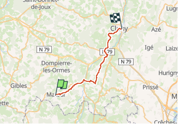
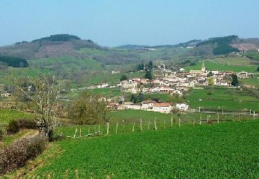
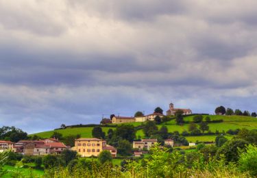
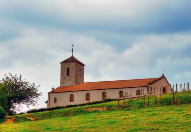
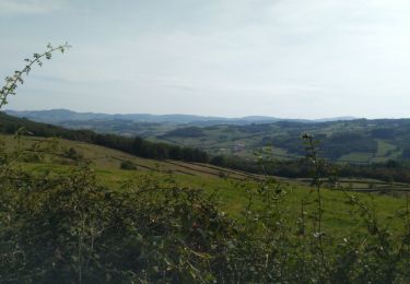
Randonnée A pied de 29 km à découvrir à Bourgogne-Franche-Comté, Saône-et-Loire, Matour. Cette randonnée est proposée par chessyca.
Description
5 ème étape du trek de 6 jours
Matour Cluny
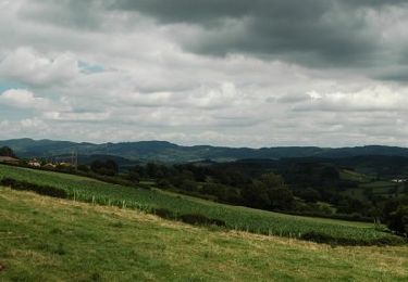
Journée catastrophe avec une météo vraiment pourrie du matin au soir au point d'en changer le tracé du lendemain .
Localisation
Pays :
France
Région :
Bourgogne-Franche-Comté
Département/Province :
Saône-et-Loire
Commune :
Matour
Localité :
Unknown
Départ:(Dec)
Départ:(UTM)
614006 ; 5129081 (31T) N.
Commentaires
Randonnées à proximité
![Randonnée A pied Aigueperse - Circuit d'Aigueperse - Photo](https://media.geolcdn.com/t/375/260/089ba32e-d836-4768-87ed-3f863068c4e0.jpeg&format=jpg&maxdim=2)
![A pied A pied](https://static1.geolcdn.com/sitytour/trail-icons/100.png)
Circuit d'Aigueperse
A pied
Moyen
Aigueperse,
Auvergne-Rhône-Alpes,
Rhône,
France
![](/images/other/stat-length.png)
20 km | 29 km-effort
6h 34min
![](https://static1.geolcdn.com/siteimages/upload/files/16400158638029165_repeat_loop_refresh_sync_direction_icon.png)
Oui
![Randonnée Marche Trambly - Trambly - Saint Leger sous la Bussière - Photo](https://media.geolcdn.com/t/375/260/ext.jpg?maxdim=2&url=https%3A%2F%2Fservices.sitytrail.com%2FGeolivesWS%2FDownloadMedia.ashx%3FTrailID%3D971497%26Media%3D20180521155547.jpg)
![Marche Marche](https://static1.geolcdn.com/sitytour/trail-icons/101.png)
Trambly - Saint Leger sous la Bussière
Marche
Très facile
Trambly,
Bourgogne-Franche-Comté,
Saône-et-Loire,
France
![](/images/other/stat-length.png)
12,8 km | 18,5 km-effort
3h 54min
![](https://static1.geolcdn.com/siteimages/upload/files/16400158638029165_repeat_loop_refresh_sync_direction_icon.png)
Oui
![Randonnée V.T.T. Trambly - Les Serpentines (2012-VTT-25km) - Trambly - Photo](https://media.geolcdn.com/t/375/260/ext.jpg?maxdim=2&url=https%3A%2F%2Fservices.sitytrail.com%2FGeolivesWS%2FDownloadMedia.ashx%3FTrailID%3D129628%26Media%3D13145_6.jpg)
![V.T.T. V.T.T.](https://static1.geolcdn.com/sitytour/trail-icons/202.png)
Les Serpentines (2012-VTT-25km) - Trambly
V.T.T.
Difficile
Trambly,
Bourgogne-Franche-Comté,
Saône-et-Loire,
France
![](/images/other/stat-length.png)
25 km | 36 km-effort
2h 30min
![](https://static1.geolcdn.com/siteimages/upload/files/16400158638029165_repeat_loop_refresh_sync_direction_icon.png)
Oui
![Randonnée V.T.T. Trambly - Les Serpentines (2012-VTT-35km) - Trambly - Photo](https://media.geolcdn.com/t/375/260/ext.jpg?maxdim=2&url=https%3A%2F%2Fservices.sitytrail.com%2FGeolivesWS%2FDownloadMedia.ashx%3FTrailID%3D129627%26Media%3D13144_6.jpg)
![V.T.T. V.T.T.](https://static1.geolcdn.com/sitytour/trail-icons/202.png)
Les Serpentines (2012-VTT-35km) - Trambly
V.T.T.
Très difficile
Trambly,
Bourgogne-Franche-Comté,
Saône-et-Loire,
France
![](/images/other/stat-length.png)
36 km | 52 km-effort
3h 0min
![](https://static1.geolcdn.com/siteimages/upload/files/16400158638029165_repeat_loop_refresh_sync_direction_icon.png)
Oui
![Randonnée Marche Deux-Grosnes - Circuit de St-Christophe-la-Montagne (10,5 km) - Photo](https://media.geolcdn.com/t/375/260/ext.jpg?maxdim=2&url=https%3A%2F%2Fservices.sitytrail.com%2FGeolivesWS%2FDownloadMedia.ashx%3FTrailID%3D112075%26Media%3D9683_3.jpg)
![Marche Marche](https://static1.geolcdn.com/sitytour/trail-icons/101.png)
Circuit de St-Christophe-la-Montagne (10,5 km)
Marche
Moyen
Deux-Grosnes,
Auvergne-Rhône-Alpes,
Rhône,
France
![](/images/other/stat-length.png)
10,5 km | 14,8 km-effort
2h 40min
![](https://static1.geolcdn.com/siteimages/upload/files/16400158638029165_repeat_loop_refresh_sync_direction_icon.png)
Oui
![Randonnée Marche Deux-Grosnes - Circuit de St-Christophe-la-Montagne (12 km) - Photo](https://media.geolcdn.com/t/375/260/ext.jpg?maxdim=2&url=https%3A%2F%2Fservices.sitytrail.com%2FGeolivesWS%2FDownloadMedia.ashx%3FTrailID%3D112074%26Media%3D9682_3.jpg)
![Marche Marche](https://static1.geolcdn.com/sitytour/trail-icons/101.png)
Circuit de St-Christophe-la-Montagne (12 km)
Marche
Difficile
Deux-Grosnes,
Auvergne-Rhône-Alpes,
Rhône,
France
![](/images/other/stat-length.png)
11,9 km | 18,2 km-effort
3h 0min
![](https://static1.geolcdn.com/siteimages/upload/files/16400158638029165_repeat_loop_refresh_sync_direction_icon.png)
Oui
![Randonnée Marche Deux-Grosnes - Circuit de St-Christophe-la-Montagne (4 km) - Photo](https://media.geolcdn.com/t/375/260/ext.jpg?maxdim=2&url=https%3A%2F%2Fservices.sitytrail.com%2FGeolivesWS%2FDownloadMedia.ashx%3FTrailID%3D112073%26Media%3D9681_3.jpg)
![Marche Marche](https://static1.geolcdn.com/sitytour/trail-icons/101.png)
Circuit de St-Christophe-la-Montagne (4 km)
Marche
Facile
Deux-Grosnes,
Auvergne-Rhône-Alpes,
Rhône,
France
![](/images/other/stat-length.png)
4 km | 5,5 km-effort
1h 0min
![](https://static1.geolcdn.com/siteimages/upload/files/16400158638029165_repeat_loop_refresh_sync_direction_icon.png)
Oui
![Randonnée Marche Deux-Grosnes - Circuit de St-Christophe-la-Montagne (21km) - Photo](https://media.geolcdn.com/t/375/260/ext.jpg?maxdim=2&url=https%3A%2F%2Fservices.sitytrail.com%2FGeolivesWS%2FDownloadMedia.ashx%3FTrailID%3D112072%26Media%3D9680_1.jpg)
![Marche Marche](https://static1.geolcdn.com/sitytour/trail-icons/101.png)
Circuit de St-Christophe-la-Montagne (21km)
Marche
Très difficile
Deux-Grosnes,
Auvergne-Rhône-Alpes,
Rhône,
France
![](/images/other/stat-length.png)
21 km | 31 km-effort
5h 19min
![](https://static1.geolcdn.com/siteimages/upload/files/16400158638029165_repeat_loop_refresh_sync_direction_icon.png)
Oui
![Randonnée Marche Saint-Bonnet-des-Bruyères - La Michèle - Photo](https://media.geolcdn.com/t/375/260/98c59451-ee9e-4eec-9bbd-893a4de4375a.jpg&format=jpg&maxdim=2)
![Marche Marche](https://static1.geolcdn.com/sitytour/trail-icons/101.png)
La Michèle
Marche
Moyen
(1)
Saint-Bonnet-des-Bruyères,
Auvergne-Rhône-Alpes,
Rhône,
France
![](/images/other/stat-length.png)
12 km | 16,4 km-effort
2h 57min
![](https://static1.geolcdn.com/siteimages/upload/files/16400158638029165_repeat_loop_refresh_sync_direction_icon.png)
Oui