![](/images/other/stat-length.png)
![Randonnée A pied Crozon - Vers l'ïle de L'Aber boucle 14 km - Photo](https://media.geolcdn.com/t/1900/400/ext.pjpeg?maxdim=2&url=https%3A%2F%2Fstatic1.geolcdn.com%2Fsiteimages%2Fupload%2Ffiles%2F1545311037marcheuse_200dpi.jpg)
Vers l'ïle de L'Aber boucle 14 km
chessyca
Utilisateur
![Longueur](/images/other/stat-length.png)
Longueur
12,8 km
![Altitude max](https://static1.geolcdn.com/siteimages/upload/files/1508320355ic_sort_altitude_max_24dp.png)
Altitude max
88 m
![Dénivelé positif](https://static1.geolcdn.com/siteimages/upload/files/1508320355ic_sort_den_pos_24dp.png)
Dénivelé positif
206 m
![Km-Effort](/images/other/stat-length.png)
Km-Effort
15,6 km
![Altitude min](https://static1.geolcdn.com/siteimages/upload/files/1508320355ic_sort_altitude_min_24dp.png)
Altitude min
0 m
![Dénivelé négatif](https://static1.geolcdn.com/siteimages/upload/files/1508320355ic_sort_den_neg_24dp.png)
Dénivelé négatif
208 m
![Boucle](https://static1.geolcdn.com/siteimages/upload/files/16400158638029165_repeat_loop_refresh_sync_direction_icon.png)
Boucle
Non
Date de création :
2024-06-15 10:56:27.687
Dernière modification :
2024-06-15 11:29:51.689
![A pied](https://static1.geolcdn.com/sitytour/trail-icons/100.png)
3h32
Difficulté : Facile
![Scannez ce code QR pour ouvrir la randonnée dans l'application SityTrail](https://capi.geolives.com/qq0zvz2zws4bq2lad0pu/sitytour/trails/4091328/qr.png?size=200)
Application GPS de randonnée GRATUITE
À propos
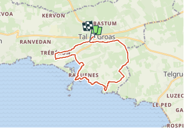
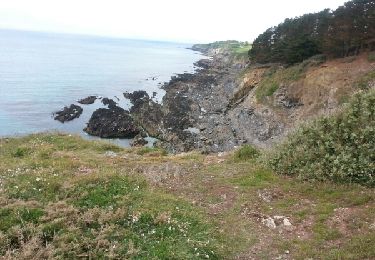
Randonnée A pied de 12,8 km à découvrir à Bretagne, Finistère, Crozon. Cette randonnée est proposée par chessyca.
Description
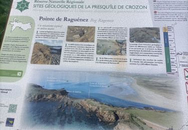
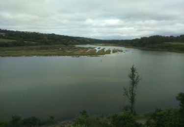
Découvrez l’estuaire de l’Aber ; milieu remarquable : frayères de daurades, mulets et poissons plats. Suivant les saisons, c’est un lieu de repos et de nourrissage pour les oiseaux migrateurs.
Localisation
Pays :
France
Région :
Bretagne
Département/Province :
Finistère
Commune :
Crozon
Localité :
Unknown
Départ:(Dec)
Départ:(UTM)
394354 ; 5344639 (30U) N.
Commentaires
Randonnées à proximité
![Randonnée Marche Crozon - le rozan vers croson - Photo](https://media.geolcdn.com/t/375/260/ext.jpg?maxdim=2&url=https%3A%2F%2Fmedia.geolcdn.com%2Ff%2F31e6bd67-267e-49f5-8a22-3a3844c2afd2.jpg)
![Marche Marche](https://static1.geolcdn.com/sitytour/trail-icons/101.png)
le rozan vers croson
Marche
Moyen
Crozon,
Bretagne,
Finistère,
France
![](/images/other/stat-length.png)
7 km | 8,8 km-effort
2h 25min
![](https://static1.geolcdn.com/siteimages/upload/files/16400158638029165_repeat_loop_refresh_sync_direction_icon.png)
Oui
![Randonnée Marche Telgruc-sur-Mer - TELGRUC - Photo](https://media.geolcdn.com/t/375/260/ext.jpg?maxdim=2&url=https%3A%2F%2Fmedia.geolcdn.com%2Ff%2F608febd5-d174-42e3-8862-bb6190cd7fdb.jpg)
![Marche Marche](https://static1.geolcdn.com/sitytour/trail-icons/101.png)
TELGRUC
Marche
Facile
Telgruc-sur-Mer,
Bretagne,
Finistère,
France
![](/images/other/stat-length.png)
13,2 km | 16,2 km-effort
3h 40min
![](https://static1.geolcdn.com/siteimages/upload/files/16400158638029165_repeat_loop_refresh_sync_direction_icon.png)
Oui
![Randonnée Marche Telgruc-sur-Mer - TELGRUC - Photo](https://media.geolcdn.com/t/375/260/ext.jpg?maxdim=2&url=https%3A%2F%2Fmedia.geolcdn.com%2Ff%2Fd19cc088-3d1d-4140-8c72-4c7d1297aea7.JPG)
![Marche Marche](https://static1.geolcdn.com/sitytour/trail-icons/101.png)
TELGRUC
Marche
Difficile
Telgruc-sur-Mer,
Bretagne,
Finistère,
France
![](/images/other/stat-length.png)
10,6 km | 13,8 km-effort
3h 8min
![](https://static1.geolcdn.com/siteimages/upload/files/16400158638029165_repeat_loop_refresh_sync_direction_icon.png)
Oui
![Randonnée Marche nordique Telgruc-sur-Mer - teldruc yrez,_bellec - Photo](https://media.geolcdn.com/t/375/260/ext.jpg?maxdim=2&url=https%3A%2F%2Fmedia.geolcdn.com%2Ff%2Fbb28c706-e2a1-4df6-a83c-a1e197a15e49.jpg)
![Marche nordique Marche nordique](https://static1.geolcdn.com/sitytour/trail-icons/102.png)
teldruc yrez,_bellec
Marche nordique
Très facile
Telgruc-sur-Mer,
Bretagne,
Finistère,
France
![](/images/other/stat-length.png)
13,6 km | 17,6 km-effort
3h 5min
![](https://static1.geolcdn.com/siteimages/upload/files/16400158638029165_repeat_loop_refresh_sync_direction_icon.png)
Oui
![Randonnée Marche Crozon - CROZON (Tal ar Groaz Sud-Est) - Photo](https://media.geolcdn.com/t/375/260/ext.jpg?maxdim=2&url=https%3A%2F%2Fservices.sitytrail.com%2FGeolivesWS%2FDownloadMedia.ashx%3FTrailID%3D1021952%26Media%3Dfix__20180814170309.jpg)
![Marche Marche](https://static1.geolcdn.com/sitytour/trail-icons/101.png)
CROZON (Tal ar Groaz Sud-Est)
Marche
Facile
Crozon,
Bretagne,
Finistère,
France
![](/images/other/stat-length.png)
13,6 km | 17 km-effort
3h 41min
![](https://static1.geolcdn.com/siteimages/upload/files/16400158638029165_repeat_loop_refresh_sync_direction_icon.png)
Oui
![Randonnée Marche Crozon - CROZON (Tal ar Groaz Ouest) - Photo](https://media.geolcdn.com/t/375/260/ext.jpg?maxdim=2&url=https%3A%2F%2Fservices.sitytrail.com%2FGeolivesWS%2FDownloadMedia.ashx%3FTrailID%3D1019403%26Media%3Dfix__20180809150113.jpg)
![Marche Marche](https://static1.geolcdn.com/sitytour/trail-icons/101.png)
CROZON (Tal ar Groaz Ouest)
Marche
Moyen
Crozon,
Bretagne,
Finistère,
France
![](/images/other/stat-length.png)
12,2 km | 14,7 km-effort
3h 24min
![](https://static1.geolcdn.com/siteimages/upload/files/16400158638029165_repeat_loop_refresh_sync_direction_icon.png)
Oui
![Randonnée Marche Lanvéoc - Le tour de LANVEOC - Photo](https://media.geolcdn.com/t/375/260/ext.jpg?maxdim=2&url=https%3A%2F%2Fservices.sitytrail.com%2FGeolivesWS%2FDownloadMedia.ashx%3FTrailID%3D483623%26Media%3Dfix__20151018111534.jpg)
![Marche Marche](https://static1.geolcdn.com/sitytour/trail-icons/101.png)
Le tour de LANVEOC
Marche
Moyen
Lanvéoc,
Bretagne,
Finistère,
France
![](/images/other/stat-length.png)
20 km | 25 km-effort
5h 43min
![](https://static1.geolcdn.com/siteimages/upload/files/16400158638029165_repeat_loop_refresh_sync_direction_icon.png)
Non
![Randonnée Marche Crozon - GR 34 étape 40 - Photo](https://media.geolcdn.com/t/375/260/ext.jpg?maxdim=2&url=https%3A%2F%2Fservices.sitytrail.com%2FGeolivesWS%2FDownloadMedia.ashx%3FTrailID%3D318953%26Media%3Dfix__20140530122803.jpg)
![Marche Marche](https://static1.geolcdn.com/sitytour/trail-icons/101.png)
![Randonnée Marche Telgruc-sur-Mer - 2012-09-22 12h33m22 - Photo](https://media.geolcdn.com/t/375/260/ext.jpg?maxdim=2&url=https%3A%2F%2Fstatic1.geolcdn.com%2Fsiteimages%2Fupload%2Ffiles%2F1553511878bg_sport_marche.png)
![Marche Marche](https://static1.geolcdn.com/sitytour/trail-icons/101.png)
2012-09-22 12h33m22
Marche
Facile
(1)
Telgruc-sur-Mer,
Bretagne,
Finistère,
France
![](/images/other/stat-length.png)
6,3 km | 8,5 km-effort
1h 40min
![](https://static1.geolcdn.com/siteimages/upload/files/16400158638029165_repeat_loop_refresh_sync_direction_icon.png)
Oui