![](/images/other/stat-length.png)
![Randonnée A pied Rosnoën - Le Saut Du Loup Boucle 13 km - Photo](https://media.geolcdn.com/t/1900/400/ext.pjpeg?maxdim=2&url=https%3A%2F%2Fstatic1.geolcdn.com%2Fsiteimages%2Fupload%2Ffiles%2F1545311037marcheuse_200dpi.jpg)
Le Saut Du Loup Boucle 13 km
chessyca
Utilisateur
![Longueur](/images/other/stat-length.png)
Longueur
12,6 km
![Altitude max](https://static1.geolcdn.com/siteimages/upload/files/1508320355ic_sort_altitude_max_24dp.png)
Altitude max
143 m
![Dénivelé positif](https://static1.geolcdn.com/siteimages/upload/files/1508320355ic_sort_den_pos_24dp.png)
Dénivelé positif
322 m
![Km-Effort](/images/other/stat-length.png)
Km-Effort
16,9 km
![Altitude min](https://static1.geolcdn.com/siteimages/upload/files/1508320355ic_sort_altitude_min_24dp.png)
Altitude min
0 m
![Dénivelé négatif](https://static1.geolcdn.com/siteimages/upload/files/1508320355ic_sort_den_neg_24dp.png)
Dénivelé négatif
316 m
![Boucle](https://static1.geolcdn.com/siteimages/upload/files/16400158638029165_repeat_loop_refresh_sync_direction_icon.png)
Boucle
Oui
Date de création :
2024-06-15 10:56:24.117
Dernière modification :
2024-06-15 11:20:18.287
![A pied](https://static1.geolcdn.com/sitytour/trail-icons/100.png)
3h50
Difficulté : Facile
![Scannez ce code QR pour ouvrir la randonnée dans l'application SityTrail](https://capi.geolives.com/qq0zvz2zws4bq2lad0pu/sitytour/trails/4091318/qr.png?size=200)
Application GPS de randonnée GRATUITE
À propos
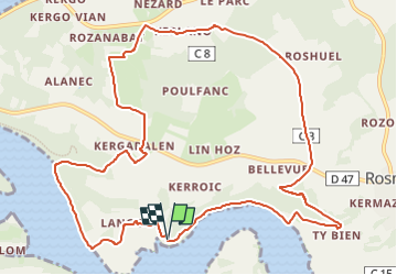
Randonnée A pied de 12,6 km à découvrir à Bretagne, Finistère, Rosnoën. Cette randonnée est proposée par chessyca.
Description
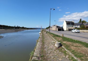
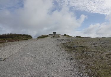
Du belvédère de Bellevue qui domine l’estuaire de l’Aulne maritime, cette randonnée, par vallons et collines, vous permettra de dominer la rivière du Faou et de découvrir le fond de la rade de Brest.
Localisation
Pays :
France
Région :
Bretagne
Département/Province :
Finistère
Commune :
Rosnoën
Localité :
Unknown
Départ:(Dec)
Départ:(UTM)
408617 ; 5345663 (30U) N.
Commentaires
Randonnées à proximité
![Randonnée Marche Trégarvan - Menez Hom_10,3km_Trace GPS - Photo](https://media.geolcdn.com/t/375/260/ext.jpg?maxdim=2&url=https%3A%2F%2Fstatic1.geolcdn.com%2Fsiteimages%2Fupload%2Ffiles%2F1553511878bg_sport_marche.png)
![Marche Marche](https://static1.geolcdn.com/sitytour/trail-icons/101.png)
Menez Hom_10,3km_Trace GPS
Marche
Moyen
(1)
Trégarvan,
Bretagne,
Finistère,
France
![](/images/other/stat-length.png)
10,2 km | 14 km-effort
3h 0min
![](https://static1.geolcdn.com/siteimages/upload/files/16400158638029165_repeat_loop_refresh_sync_direction_icon.png)
Oui
![Randonnée Marche Trégarvan - TREGARVAN_6,7km_Trace GPS - Photo](https://media.geolcdn.com/t/375/260/ext.jpg?maxdim=2&url=https%3A%2F%2Fstatic1.geolcdn.com%2Fsiteimages%2Fupload%2Ffiles%2F1553511878bg_sport_marche.png)
![Marche Marche](https://static1.geolcdn.com/sitytour/trail-icons/101.png)
TREGARVAN_6,7km_Trace GPS
Marche
Facile
(1)
Trégarvan,
Bretagne,
Finistère,
France
![](/images/other/stat-length.png)
6,7 km | 8,4 km-effort
1h 50min
![](https://static1.geolcdn.com/siteimages/upload/files/16400158638029165_repeat_loop_refresh_sync_direction_icon.png)
Oui
![Randonnée Marche Landévennec - LANDÉVENNEC - Photo](https://media.geolcdn.com/t/375/260/ext.jpg?maxdim=2&url=https%3A%2F%2Fmedia.geolcdn.com%2Ff%2F3aa9913a-4da7-4716-a24d-72b5f897ad92.jpg)
![Marche Marche](https://static1.geolcdn.com/sitytour/trail-icons/101.png)
LANDÉVENNEC
Marche
Difficile
Landévennec,
Bretagne,
Finistère,
France
![](/images/other/stat-length.png)
19,4 km | 25 km-effort
4h 41min
![](https://static1.geolcdn.com/siteimages/upload/files/16400158638029165_repeat_loop_refresh_sync_direction_icon.png)
Non
![Randonnée Marche Le Faou - GRP_Crozon_CB_01_Le-Faou_Argol_20200919 - Photo](https://media.geolcdn.com/t/375/260/ext.jpg?maxdim=2&url=https%3A%2F%2Fmedia.geolcdn.com%2Ff%2Ffbd34cbb-bebb-46b9-8e23-76c365c1b8c8.jpg)
![Marche Marche](https://static1.geolcdn.com/sitytour/trail-icons/101.png)
GRP_Crozon_CB_01_Le-Faou_Argol_20200919
Marche
Moyen
Le Faou,
Bretagne,
Finistère,
France
![](/images/other/stat-length.png)
15,9 km | 21 km-effort
4h 31min
![](https://static1.geolcdn.com/siteimages/upload/files/16400158638029165_repeat_loop_refresh_sync_direction_icon.png)
Non
![Randonnée Marche Le Faou - La randonnée du Faou - Photo](https://media.geolcdn.com/t/375/260/ext.jpg?maxdim=2&url=https%3A%2F%2Fmedia.geolcdn.com%2Ff%2F52fdc54d-e20e-467f-ae3e-b4bd86da525e.jpg)
![Marche Marche](https://static1.geolcdn.com/sitytour/trail-icons/101.png)
La randonnée du Faou
Marche
Moyen
Le Faou,
Bretagne,
Finistère,
France
![](/images/other/stat-length.png)
9,4 km | 11,6 km-effort
3h 37min
![](https://static1.geolcdn.com/siteimages/upload/files/16400158638029165_repeat_loop_refresh_sync_direction_icon.png)
Oui
![Randonnée A pied Saint-Nic - Circuit du Menez-Hom - Photo](https://media.geolcdn.com/t/375/260/ext.jpg?maxdim=2&url=https%3A%2F%2Fmedia.geolcdn.com%2Ff%2F760775ab-c8f5-4115-9a49-824ff941c9f9.jpeg)
![A pied A pied](https://static1.geolcdn.com/sitytour/trail-icons/100.png)
Circuit du Menez-Hom
A pied
Facile
Saint-Nic,
Bretagne,
Finistère,
France
![](/images/other/stat-length.png)
4,8 km | 6 km-effort
1h 22min
![](https://static1.geolcdn.com/siteimages/upload/files/16400158638029165_repeat_loop_refresh_sync_direction_icon.png)
Non
![Randonnée Marche Le Faou - GR_37_FC_14_Le-Faou_Argol_20200919 - Photo](https://media.geolcdn.com/t/375/260/ext.jpg?maxdim=2&url=https%3A%2F%2Fmedia.geolcdn.com%2Ff%2Ffbd34cbb-bebb-46b9-8e23-76c365c1b8c8.jpg)
![Marche Marche](https://static1.geolcdn.com/sitytour/trail-icons/101.png)
GR_37_FC_14_Le-Faou_Argol_20200919
Marche
Moyen
Le Faou,
Bretagne,
Finistère,
France
![](/images/other/stat-length.png)
15,9 km | 21 km-effort
4h 31min
![](https://static1.geolcdn.com/siteimages/upload/files/16400158638029165_repeat_loop_refresh_sync_direction_icon.png)
Non
![Randonnée Marche Landévennec - Landévennec - boucles locales et GR34 - 13.8km 250m 4h10 (35mn) - 2019 09 12 - Photo](https://media.geolcdn.com/t/375/260/ext.jpg?maxdim=2&url=https%3A%2F%2Fmedia.geolcdn.com%2Ff%2Fed0a847b-b2f3-4f8e-b6b5-8e6353637e62.jpg)
![Marche Marche](https://static1.geolcdn.com/sitytour/trail-icons/101.png)
Landévennec - boucles locales et GR34 - 13.8km 250m 4h10 (35mn) - 2019 09 12
Marche
Facile
Landévennec,
Bretagne,
Finistère,
France
![](/images/other/stat-length.png)
13,8 km | 17,2 km-effort
4h 10min
![](https://static1.geolcdn.com/siteimages/upload/files/16400158638029165_repeat_loop_refresh_sync_direction_icon.png)
Oui
![Randonnée Marche Saint-Nic - Saint Nic - boucle Ménez Hom et Dolmen de Ménez Lié - 11.1km 305m 3h10 - 2019 09 07 - Photo](https://media.geolcdn.com/t/375/260/ext.jpg?maxdim=2&url=https%3A%2F%2Fmedia.geolcdn.com%2Ff%2Ff8f13a6f-f2d0-45cb-84dc-d3b1b35f6896.jpg)
![Marche Marche](https://static1.geolcdn.com/sitytour/trail-icons/101.png)
Saint Nic - boucle Ménez Hom et Dolmen de Ménez Lié - 11.1km 305m 3h10 - 2019...
Marche
Facile
Saint-Nic,
Bretagne,
Finistère,
France
![](/images/other/stat-length.png)
11,1 km | 15,2 km-effort
3h 10min
![](https://static1.geolcdn.com/siteimages/upload/files/16400158638029165_repeat_loop_refresh_sync_direction_icon.png)
Oui