![](/images/other/stat-length.png)
![Randonnée Marche Rion-des-Landes - Prit (2 tracés) - Photo](https://media.geolcdn.com/t/1900/400/ext.pjpeg?maxdim=2&url=https%3A%2F%2Fstatic1.geolcdn.com%2Fsiteimages%2Fupload%2Ffiles%2F1553511878bg_sport_marche.png)
Prit (2 tracés)
les randonneurs rionnais
Pignada nous voilà
![Longueur](/images/other/stat-length.png)
Longueur
879 m
![Altitude max](https://static1.geolcdn.com/siteimages/upload/files/1508320355ic_sort_altitude_max_24dp.png)
Altitude max
78 m
![Dénivelé positif](https://static1.geolcdn.com/siteimages/upload/files/1508320355ic_sort_den_pos_24dp.png)
Dénivelé positif
5 m
![Km-Effort](/images/other/stat-length.png)
Km-Effort
949 m
![Altitude min](https://static1.geolcdn.com/siteimages/upload/files/1508320355ic_sort_altitude_min_24dp.png)
Altitude min
73 m
![Dénivelé négatif](https://static1.geolcdn.com/siteimages/upload/files/1508320355ic_sort_den_neg_24dp.png)
Dénivelé négatif
6 m
![Boucle](https://static1.geolcdn.com/siteimages/upload/files/16400158638029165_repeat_loop_refresh_sync_direction_icon.png)
Boucle
Oui
Date de création :
2024-06-14 07:15:21.715
Dernière modification :
2024-06-14 09:58:53.231
![Marche](https://static1.geolcdn.com/sitytour/trail-icons/101.png)
12m
Difficulté : Facile
![Scannez ce code QR pour ouvrir la randonnée dans l'application SityTrail](https://capi.geolives.com/qq0zvz2zws4bq2lad0pu/sitytour/trails/4090145/qr.png?size=200)
Application GPS de randonnée GRATUITE
À propos
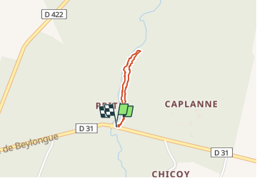
Randonnée Marche de 879 m à découvrir à Nouvelle-Aquitaine, Landes, Rion-des-Landes. Cette randonnée est proposée par les randonneurs rionnais.
Description
- trajet aller par parcelles 1 & 2
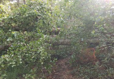
- retour hors parcelles Prit (chemin à nettoyer à la machine débrousailleuse et grand sécateur)
Localisation
Pays :
France
Région :
Nouvelle-Aquitaine
Département/Province :
Landes
Commune :
Rion-des-Landes
Localité :
Rion-des-Landes
Départ:(Dec)
Départ:(UTM)
668308 ; 4866726 (30T) N.
Commentaires
Randonnées à proximité
![Randonnée Marche Rion-des-Landes - retjons, prit, carreyre - 7 - Photo](https://media.geolcdn.com/t/375/260/ff91d5e6-2d63-47a1-ad7b-823d37ac495d.jpg&format=jpg&maxdim=2)
![Marche Marche](https://static1.geolcdn.com/sitytour/trail-icons/101.png)
retjons, prit, carreyre - 7
Marche
Moyen
(1)
Rion-des-Landes,
Nouvelle-Aquitaine,
Landes,
France
![](/images/other/stat-length.png)
7 km | 7,9 km-effort
1h 47min
![](https://static1.geolcdn.com/siteimages/upload/files/16400158638029165_repeat_loop_refresh_sync_direction_icon.png)
Oui
![Randonnée Marche Rion-des-Landes - Tuilerie, pouchon, pinache, loriou, mollenave - 7.2 - Photo](https://media.geolcdn.com/t/375/260/ext.jpg?maxdim=2&url=https%3A%2F%2Fstatic1.geolcdn.com%2Fsiteimages%2Fupload%2Ffiles%2F1553511878bg_sport_marche.png)
![Marche Marche](https://static1.geolcdn.com/sitytour/trail-icons/101.png)
Tuilerie, pouchon, pinache, loriou, mollenave - 7.2
Marche
Moyen
(1)
Rion-des-Landes,
Nouvelle-Aquitaine,
Landes,
France
![](/images/other/stat-length.png)
7,2 km | 8 km-effort
1h 48min
![](https://static1.geolcdn.com/siteimages/upload/files/16400158638029165_repeat_loop_refresh_sync_direction_icon.png)
Oui
![Randonnée Marche Rion-des-Landes - Mâa, piocs, Miconine, Carreyre, Maubay - 7.3 - Photo](https://media.geolcdn.com/t/375/260/ext.jpg?maxdim=2&url=https%3A%2F%2Fstatic1.geolcdn.com%2Fsiteimages%2Fupload%2Ffiles%2F1553511878bg_sport_marche.png)
![Marche Marche](https://static1.geolcdn.com/sitytour/trail-icons/101.png)
Mâa, piocs, Miconine, Carreyre, Maubay - 7.3
Marche
Moyen
(1)
Rion-des-Landes,
Nouvelle-Aquitaine,
Landes,
France
![](/images/other/stat-length.png)
7,3 km | 8,2 km-effort
1h 52min
![](https://static1.geolcdn.com/siteimages/upload/files/16400158638029165_repeat_loop_refresh_sync_direction_icon.png)
Oui
![Randonnée Marche Beylongue - garricq, rive gauche jusqu'à passerelle poteaux, fontaine des sorcières, le buy, cosse -9.5 - Photo](https://media.geolcdn.com/t/375/260/ext.jpg?maxdim=2&url=https%3A%2F%2Fstatic1.geolcdn.com%2Fsiteimages%2Fupload%2Ffiles%2F1553511878bg_sport_marche.png)
![Marche Marche](https://static1.geolcdn.com/sitytour/trail-icons/101.png)
garricq, rive gauche jusqu'à passerelle poteaux, fontaine des sorcières, le b...
Marche
Moyen
(1)
Beylongue,
Nouvelle-Aquitaine,
Landes,
France
![](/images/other/stat-length.png)
9,5 km | 11,2 km-effort
2h 33min
![](https://static1.geolcdn.com/siteimages/upload/files/16400158638029165_repeat_loop_refresh_sync_direction_icon.png)
Oui
![Randonnée Marche Beylongue - garricq, rive gauche jusqu'à passerelle poteaux, fontaine des sorcières, le buy, cosse -9.6 - Photo](https://media.geolcdn.com/t/375/260/ext.jpg?maxdim=2&url=https%3A%2F%2Fstatic1.geolcdn.com%2Fsiteimages%2Fupload%2Ffiles%2F1553511878bg_sport_marche.png)
![Marche Marche](https://static1.geolcdn.com/sitytour/trail-icons/101.png)
garricq, rive gauche jusqu'à passerelle poteaux, fontaine des sorcières, le b...
Marche
Moyen
(1)
Beylongue,
Nouvelle-Aquitaine,
Landes,
France
![](/images/other/stat-length.png)
9,6 km | 11,4 km-effort
2h 36min
![](https://static1.geolcdn.com/siteimages/upload/files/16400158638029165_repeat_loop_refresh_sync_direction_icon.png)
Oui
![Randonnée Marche Beylongue - garricq, rive gauche jusqu'à passerelle poteaux, fontaine des sorcières, le buy, cosse - 9.1 - Photo](https://media.geolcdn.com/t/375/260/ext.jpg?maxdim=2&url=https%3A%2F%2Fstatic1.geolcdn.com%2Fsiteimages%2Fupload%2Ffiles%2F1553511878bg_sport_marche.png)
![Marche Marche](https://static1.geolcdn.com/sitytour/trail-icons/101.png)
garricq, rive gauche jusqu'à passerelle poteaux, fontaine des sorcières, le b...
Marche
Moyen
(1)
Beylongue,
Nouvelle-Aquitaine,
Landes,
France
![](/images/other/stat-length.png)
9,1 km | 10,7 km-effort
2h 25min
![](https://static1.geolcdn.com/siteimages/upload/files/16400158638029165_repeat_loop_refresh_sync_direction_icon.png)
Oui
![Randonnée Marche Beylongue - garricq, rive gauche jusqu'à passerelle poteaux, fontaine des sorcières - 7 - Photo](https://media.geolcdn.com/t/375/260/ext.jpg?maxdim=2&url=https%3A%2F%2Fstatic1.geolcdn.com%2Fsiteimages%2Fupload%2Ffiles%2F1553511878bg_sport_marche.png)
![Marche Marche](https://static1.geolcdn.com/sitytour/trail-icons/101.png)
garricq, rive gauche jusqu'à passerelle poteaux, fontaine des sorcières - 7
Marche
Facile
(1)
Beylongue,
Nouvelle-Aquitaine,
Landes,
France
![](/images/other/stat-length.png)
7 km | 8,1 km-effort
1h 30min
![](https://static1.geolcdn.com/siteimages/upload/files/16400158638029165_repeat_loop_refresh_sync_direction_icon.png)
Oui
![Randonnée Marche Beylongue - garricq, rive gauche jusqu'à passerelle poteaux, fontaine des sorcières - 7,3 - Photo](https://media.geolcdn.com/t/375/260/ext.jpg?maxdim=2&url=https%3A%2F%2Fstatic1.geolcdn.com%2Fsiteimages%2Fupload%2Ffiles%2F1553511878bg_sport_marche.png)
![Marche Marche](https://static1.geolcdn.com/sitytour/trail-icons/101.png)
garricq, rive gauche jusqu'à passerelle poteaux, fontaine des sorcières - 7,3
Marche
Moyen
(1)
Beylongue,
Nouvelle-Aquitaine,
Landes,
France
![](/images/other/stat-length.png)
7,3 km | 8,5 km-effort
1h 55min
![](https://static1.geolcdn.com/siteimages/upload/files/16400158638029165_repeat_loop_refresh_sync_direction_icon.png)
Oui