![](/images/other/stat-length.png)
![Randonnée Sainte-Eulalie-de-Cernon - Sté Eulalie du Cernon, La Cavalerie - Photo](https://media.geolcdn.com/t/1900/400/62f0bae7-9565-4a19-929f-db61b4f7b41d.jpg&format=pjpeg&maxdim=2)
Sté Eulalie du Cernon, La Cavalerie
alinetpierre
Utilisateur
![Longueur](/images/other/stat-length.png)
Longueur
14,3 km
![Altitude max](https://static1.geolcdn.com/siteimages/upload/files/1508320355ic_sort_altitude_max_24dp.png)
Altitude max
845 m
![Dénivelé positif](https://static1.geolcdn.com/siteimages/upload/files/1508320355ic_sort_den_pos_24dp.png)
Dénivelé positif
378 m
![Km-Effort](/images/other/stat-length.png)
Km-Effort
19,3 km
![Altitude min](https://static1.geolcdn.com/siteimages/upload/files/1508320355ic_sort_altitude_min_24dp.png)
Altitude min
576 m
![Dénivelé négatif](https://static1.geolcdn.com/siteimages/upload/files/1508320355ic_sort_den_neg_24dp.png)
Dénivelé négatif
379 m
![Boucle](https://static1.geolcdn.com/siteimages/upload/files/16400158638029165_repeat_loop_refresh_sync_direction_icon.png)
Boucle
Oui
Date de création :
2024-06-08 06:24:10.0
Dernière modification :
2024-06-08 11:21:07.161
![Scannez ce code QR pour ouvrir la randonnée dans l'application SityTrail](https://capi.geolives.com/qq0zvz2zws4bq2lad0pu/sitytour/trails/4083594/qr.png?size=200)
Application GPS de randonnée GRATUITE
À propos
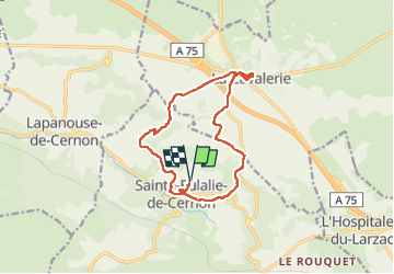
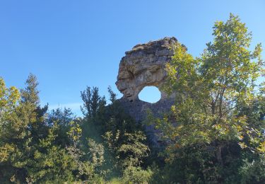
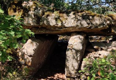
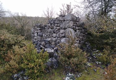
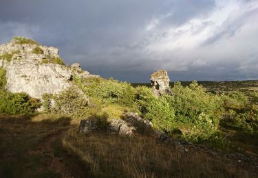
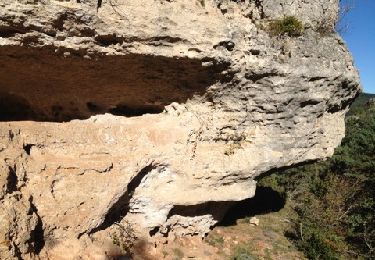
Randonnée de 14,3 km à découvrir à Occitanie, Aveyron, Sainte-Eulalie-de-Cernon. Cette randonnée est proposée par alinetpierre.
Description
Belle randonnée Villages Templiers exceptionnels .
À l’arrivée attention au sentier qui était un peu abandonner , peut être prendre la route
Localisation
Pays :
France
Région :
Occitanie
Département/Province :
Aveyron
Commune :
Sainte-Eulalie-de-Cernon
Localité :
Unknown
Départ:(Dec)
Départ:(UTM)
511097 ; 4870221 (31T) N.
Commentaires
Randonnées à proximité
![Randonnée Marche Sainte-Eulalie-de-Cernon - Sainte Eulalie de Cernon - Photo](https://media.geolcdn.com/t/375/260/ext.jpg?maxdim=2&url=https%3A%2F%2Fstatic1.geolcdn.com%2Fsiteimages%2Fupload%2Ffiles%2F1553511878bg_sport_marche.png)
![Marche Marche](https://static1.geolcdn.com/sitytour/trail-icons/101.png)
Sainte Eulalie de Cernon
Marche
Moyen
(1)
Sainte-Eulalie-de-Cernon,
Occitanie,
Aveyron,
France
![](/images/other/stat-length.png)
11,8 km | 16,9 km-effort
4h 15min
![](https://static1.geolcdn.com/siteimages/upload/files/16400158638029165_repeat_loop_refresh_sync_direction_icon.png)
Oui
![Randonnée Marche La Cavalerie - num.la cavalerie le viala - Photo](https://media.geolcdn.com/t/375/260/66b2c8c4-4396-4805-bf73-b77139ba46d0.jpg&format=jpg&maxdim=2)
![Marche Marche](https://static1.geolcdn.com/sitytour/trail-icons/101.png)
num.la cavalerie le viala
Marche
Moyen
La Cavalerie,
Occitanie,
Aveyron,
France
![](/images/other/stat-length.png)
15,2 km | 20 km-effort
3h 50min
![](https://static1.geolcdn.com/siteimages/upload/files/16400158638029165_repeat_loop_refresh_sync_direction_icon.png)
Non
![Randonnée Marche Sainte-Eulalie-de-Cernon - ste eulalie in live - Photo](https://media.geolcdn.com/t/375/260/db39a368-f6a7-49f9-9922-1b4703411825.jpg&format=jpg&maxdim=2)
![Marche Marche](https://static1.geolcdn.com/sitytour/trail-icons/101.png)
ste eulalie in live
Marche
Moyen
Sainte-Eulalie-de-Cernon,
Occitanie,
Aveyron,
France
![](/images/other/stat-length.png)
16,8 km | 25 km-effort
4h 8min
![](https://static1.geolcdn.com/siteimages/upload/files/16400158638029165_repeat_loop_refresh_sync_direction_icon.png)
Oui
![Randonnée Marche Sainte-Eulalie-de-Cernon - ste eulalie - Photo](https://media.geolcdn.com/t/375/260/d7427dab-bf6a-431f-b048-fe50d3371e78.jpg&format=jpg&maxdim=2)
![Marche Marche](https://static1.geolcdn.com/sitytour/trail-icons/101.png)
ste eulalie
Marche
Facile
Sainte-Eulalie-de-Cernon,
Occitanie,
Aveyron,
France
![](/images/other/stat-length.png)
8,8 km | 12,6 km-effort
2h 24min
![](https://static1.geolcdn.com/siteimages/upload/files/16400158638029165_repeat_loop_refresh_sync_direction_icon.png)
Oui
![Randonnée Marche Lapanouse-de-Cernon - lapanouse in live - Photo](https://media.geolcdn.com/t/375/260/90015915-fef9-4ab9-ab84-32a683f6b248.jpg&format=jpg&maxdim=2)
![Marche Marche](https://static1.geolcdn.com/sitytour/trail-icons/101.png)
lapanouse in live
Marche
Moyen
Lapanouse-de-Cernon,
Occitanie,
Aveyron,
France
![](/images/other/stat-length.png)
12,3 km | 19,3 km-effort
3h 23min
![](https://static1.geolcdn.com/siteimages/upload/files/16400158638029165_repeat_loop_refresh_sync_direction_icon.png)
Oui
![Randonnée Marche La Cavalerie - St Eulalie de Cernon - Photo](https://media.geolcdn.com/t/375/260/0a20ec79-7da7-496f-aef6-9b7268bcdc9b.jpg&format=jpg&maxdim=2)
![Marche Marche](https://static1.geolcdn.com/sitytour/trail-icons/101.png)
St Eulalie de Cernon
Marche
Moyen
La Cavalerie,
Occitanie,
Aveyron,
France
![](/images/other/stat-length.png)
13,5 km | 19,1 km-effort
3h 9min
![](https://static1.geolcdn.com/siteimages/upload/files/16400158638029165_repeat_loop_refresh_sync_direction_icon.png)
Non
![Randonnée Marche Sainte-Eulalie-de-Cernon - boîtes jaunes - Photo](https://media.geolcdn.com/t/375/260/ed261ed4-fb42-4a95-b196-ac168909c0d2.jpg&format=jpg&maxdim=2)
![Marche Marche](https://static1.geolcdn.com/sitytour/trail-icons/101.png)
boîtes jaunes
Marche
Très facile
Sainte-Eulalie-de-Cernon,
Occitanie,
Aveyron,
France
![](/images/other/stat-length.png)
14,5 km | 17,8 km-effort
3h 38min
![](https://static1.geolcdn.com/siteimages/upload/files/16400158638029165_repeat_loop_refresh_sync_direction_icon.png)
Oui
![Randonnée Marche Viala-du-Pas-de-Jaux - lapanouse - Photo](https://media.geolcdn.com/t/375/260/f4e6d445-25eb-4b71-b04c-48ccd4a28f8c.jpg&format=jpg&maxdim=2)
![Marche Marche](https://static1.geolcdn.com/sitytour/trail-icons/101.png)
lapanouse
Marche
Très facile
Viala-du-Pas-de-Jaux,
Occitanie,
Aveyron,
France
![](/images/other/stat-length.png)
4,2 km | 4,9 km-effort
1h 50min
![](https://static1.geolcdn.com/siteimages/upload/files/16400158638029165_repeat_loop_refresh_sync_direction_icon.png)
Non
![Randonnée Marche Sainte-Eulalie-de-Cernon - autour de Sté eu l'amie - Photo](https://media.geolcdn.com/t/375/260/ext.jpg?maxdim=2&url=https%3A%2F%2Fservices.sitytrail.com%2FGeolivesWS%2FDownloadMedia.ashx%3FTrailID%3D158316%26Media%3D20121015153647.jpg)
![Marche Marche](https://static1.geolcdn.com/sitytour/trail-icons/101.png)
autour de Sté eu l'amie
Marche
Très facile
Sainte-Eulalie-de-Cernon,
Occitanie,
Aveyron,
France
![](/images/other/stat-length.png)
10 km | 13,9 km-effort
2h 49min
![](https://static1.geolcdn.com/siteimages/upload/files/16400158638029165_repeat_loop_refresh_sync_direction_icon.png)
Oui