![](/images/other/stat-length.png)
![Randonnée Marche Saint-Zacharie - Boucle Saint Zacharie - Photo](https://media.geolcdn.com/t/1900/400/ext.pjpeg?maxdim=2&url=https%3A%2F%2Fstatic1.geolcdn.com%2Fsiteimages%2Fupload%2Ffiles%2F1553511878bg_sport_marche.png)
Boucle Saint Zacharie
bourrin83
Utilisateur
![Longueur](/images/other/stat-length.png)
Longueur
19,9 km
![Altitude max](https://static1.geolcdn.com/siteimages/upload/files/1508320355ic_sort_altitude_max_24dp.png)
Altitude max
646 m
![Dénivelé positif](https://static1.geolcdn.com/siteimages/upload/files/1508320355ic_sort_den_pos_24dp.png)
Dénivelé positif
573 m
![Km-Effort](/images/other/stat-length.png)
Km-Effort
28 km
![Altitude min](https://static1.geolcdn.com/siteimages/upload/files/1508320355ic_sort_altitude_min_24dp.png)
Altitude min
266 m
![Dénivelé négatif](https://static1.geolcdn.com/siteimages/upload/files/1508320355ic_sort_den_neg_24dp.png)
Dénivelé négatif
576 m
![Boucle](https://static1.geolcdn.com/siteimages/upload/files/16400158638029165_repeat_loop_refresh_sync_direction_icon.png)
Boucle
Oui
Date de création :
2019-02-27 18:49:57.029
Dernière modification :
2019-02-27 18:49:57.118
![Marche](https://static1.geolcdn.com/sitytour/trail-icons/101.png)
6h01
Difficulté : Moyen
![Scannez ce code QR pour ouvrir la randonnée dans l'application SityTrail](https://capi.geolives.com/qq0zvz2zws4bq2lad0pu/sitytour/trails/408356/qr.png?size=200)
Application GPS de randonnée GRATUITE
À propos
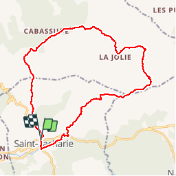
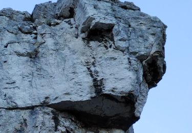
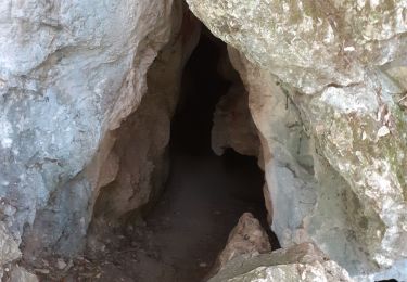
Randonnée Marche de 19,9 km à découvrir à Provence-Alpes-Côte d'Azur, Var, Saint-Zacharie. Cette randonnée est proposée par bourrin83.
Description
Au départ de Saint Zacharie , montée à l'Ermitage de Saint Jean, Passage au pied du mont Olympe , Le Clos Barry et retour par le GR
Localisation
Pays :
France
Région :
Provence-Alpes-Côte d'Azur
Département/Province :
Var
Commune :
Saint-Zacharie
Localité :
Unknown
Départ:(Dec)
Départ:(UTM)
719238 ; 4807135 (31T) N.
Commentaires
Randonnées à proximité
![Randonnée V.T.T. Trets - les contreforts du mont Olympe - Photo](https://media.geolcdn.com/t/375/260/ext.jpg?maxdim=2&url=https%3A%2F%2Fservices.sitytrail.com%2FGeolivesWS%2FDownloadMedia.ashx%3FTrailID%3D675672%26Media%3Dfix__20161223150806.jpg)
![V.T.T. V.T.T.](https://static1.geolcdn.com/sitytour/trail-icons/202.png)
les contreforts du mont Olympe
V.T.T.
Facile
(1)
Trets,
Provence-Alpes-Côte d'Azur,
Bouches-du-Rhône,
France
![](/images/other/stat-length.png)
11,8 km | 15,5 km-effort
2h 52min
![](https://static1.geolcdn.com/siteimages/upload/files/16400158638029165_repeat_loop_refresh_sync_direction_icon.png)
Oui
![Randonnée Marche Auriol - la crete des infernets - Photo](https://media.geolcdn.com/t/375/260/ext.jpg?maxdim=2&url=https%3A%2F%2Fservices.sitytrail.com%2FGeolivesWS%2FDownloadMedia.ashx%3FTrailID%3D867921%26Media%3Dfix__20171126111949.jpg)
![Marche Marche](https://static1.geolcdn.com/sitytour/trail-icons/101.png)
la crete des infernets
Marche
Difficile
(1)
Auriol,
Provence-Alpes-Côte d'Azur,
Bouches-du-Rhône,
France
![](/images/other/stat-length.png)
8,6 km | 14 km-effort
3h 22min
![](https://static1.geolcdn.com/siteimages/upload/files/16400158638029165_repeat_loop_refresh_sync_direction_icon.png)
Oui
![Randonnée Marche Saint-Zacharie - Sources des Nayes - Photo](https://media.geolcdn.com/t/375/260/f10876bf-7b9c-4295-a050-83953c85f7a8.jpg&format=jpg&maxdim=2)
![Marche Marche](https://static1.geolcdn.com/sitytour/trail-icons/101.png)
Sources des Nayes
Marche
Moyen
Saint-Zacharie,
Provence-Alpes-Côte d'Azur,
Var,
France
![](/images/other/stat-length.png)
7,6 km | 9,6 km-effort
1h 47min
![](https://static1.geolcdn.com/siteimages/upload/files/16400158638029165_repeat_loop_refresh_sync_direction_icon.png)
Oui
![Randonnée Marche Auriol - le ravin des Encanaux - Photo](https://media.geolcdn.com/t/375/260/0d6477e8-e2d8-4d99-b893-ff8f37b49a9c.jpg&format=jpg&maxdim=2)
![Marche Marche](https://static1.geolcdn.com/sitytour/trail-icons/101.png)
le ravin des Encanaux
Marche
Difficile
Auriol,
Provence-Alpes-Côte d'Azur,
Bouches-du-Rhône,
France
![](/images/other/stat-length.png)
7,3 km | 12,2 km-effort
3h 10min
![](https://static1.geolcdn.com/siteimages/upload/files/16400158638029165_repeat_loop_refresh_sync_direction_icon.png)
Oui
![Randonnée Marche Saint-Zacharie - Source de l'Huveaune - Photo](https://media.geolcdn.com/t/375/260/ext.jpg?maxdim=2&url=https%3A%2F%2Fservices.sitytrail.com%2FGeolivesWS%2FDownloadMedia.ashx%3FTrailID%3D393138%26Media%3Dfix__20150307141431.jpg)
![Marche Marche](https://static1.geolcdn.com/sitytour/trail-icons/101.png)
Source de l'Huveaune
Marche
Facile
Saint-Zacharie,
Provence-Alpes-Côte d'Azur,
Var,
France
![](/images/other/stat-length.png)
15,2 km | 19,7 km-effort
4h 24min
![](https://static1.geolcdn.com/siteimages/upload/files/16400158638029165_repeat_loop_refresh_sync_direction_icon.png)
Oui
![Randonnée Marche Auriol - Les Encanaux, Auriol-05-06-24 - Photo](https://media.geolcdn.com/t/375/260/4f585078-9323-4b69-b9ad-98d39eead66e.jpg&format=jpg&maxdim=2)
![Marche Marche](https://static1.geolcdn.com/sitytour/trail-icons/101.png)
Les Encanaux, Auriol-05-06-24
Marche
Moyen
Auriol,
Provence-Alpes-Côte d'Azur,
Bouches-du-Rhône,
France
![](/images/other/stat-length.png)
15,4 km | 24 km-effort
4h 9min
![](https://static1.geolcdn.com/siteimages/upload/files/16400158638029165_repeat_loop_refresh_sync_direction_icon.png)
Oui
![Randonnée Marche Auriol - les Encanaux - Photo](https://media.geolcdn.com/t/375/260/3bba590b-d41b-4fbd-a3a9-76850bb610aa.jpg&format=jpg&maxdim=2)
![Marche Marche](https://static1.geolcdn.com/sitytour/trail-icons/101.png)
les Encanaux
Marche
Difficile
Auriol,
Provence-Alpes-Côte d'Azur,
Bouches-du-Rhône,
France
![](/images/other/stat-length.png)
7,1 km | 11 km-effort
2h 14min
![](https://static1.geolcdn.com/siteimages/upload/files/16400158638029165_repeat_loop_refresh_sync_direction_icon.png)
Oui
![Randonnée Marche Auriol - Ravin des Infernets -Tête de chien - Photo](https://media.geolcdn.com/t/375/260/87e67d84-cabc-4812-80f4-0f6a5c04faa5.jpg&format=jpg&maxdim=2)
![Marche Marche](https://static1.geolcdn.com/sitytour/trail-icons/101.png)
Ravin des Infernets -Tête de chien
Marche
Très difficile
Auriol,
Provence-Alpes-Côte d'Azur,
Bouches-du-Rhône,
France
![](/images/other/stat-length.png)
13,7 km | 22 km-effort
9h 33min
![](https://static1.geolcdn.com/siteimages/upload/files/16400158638029165_repeat_loop_refresh_sync_direction_icon.png)
Oui
![Randonnée Marche Plan-d'Aups-Sainte-Baume - l'huveaune - Photo](https://media.geolcdn.com/t/375/260/cd28fc6a-2cc4-4f9b-9d4f-0cc5e850011b.jpg&format=jpg&maxdim=2)
![Marche Marche](https://static1.geolcdn.com/sitytour/trail-icons/101.png)
l'huveaune
Marche
Très difficile
Plan-d'Aups-Sainte-Baume,
Provence-Alpes-Côte d'Azur,
Var,
France
![](/images/other/stat-length.png)
15,4 km | 25 km-effort
7h 52min
![](https://static1.geolcdn.com/siteimages/upload/files/16400158638029165_repeat_loop_refresh_sync_direction_icon.png)
Oui