marienberg SityTrail > Randonnées > Outdoor > Autriche > Tyrol > Bezirk Imst > Gemeinde Obsteig SityTrail > Randonnées > Outdoor > Autriche > Tyrol > Bezirk Imst > Gemeinde Obsteig marienberg Nicole SIMONNET Utilisateur 3D © OpenStreetMap contributors Longueur 11,2 km Altitude max 1793 m Dénivelé positif 673 m Km-Effort 20 km Altitude min 1148 m Dénivelé négatif 669 m Boucle Oui Date de création : 2024-06-07 08:05:47.613 Dernière modification : 2024-06-07 15:40:19.638 (0 Avis) Marche 4h23 Difficulté : Difficile Application GPS de randonnée GRATUITE SityTrail IGN / Instituts géographiques SityTrail World Le monde est à vous À propos Randonnée Marche de 11,2 km à découvrir à Tyrol, Bezirk Imst, Gemeinde Obsteig. Cette randonnée est proposée par Nicole SIMONNET. Légendes | Plus de détails (PDF) Profil altimétrique Légendes > 15% 15% - 10% 10% - 5% à plat 5% - 10% 10% - 15% 15% - 30% > 30% Photos Localisation Pays : Autriche Région : Tyrol Département/Province : Bezirk Imst Commune : Gemeinde Obsteig Localité : Unknown Départ:(Dec) 47.3116854 / 10.9026631 Départ:(UTM) 643806 ; 5241557 (32T) N. Commentaires Veuillez vous connecter pour laisser un commentaire ou une note Randonnées à proximité daniel34 point de vue de Lake Autre activité Moyen Gemeinde Obsteig, Tyrol, Bezirk Imst, Autriche 
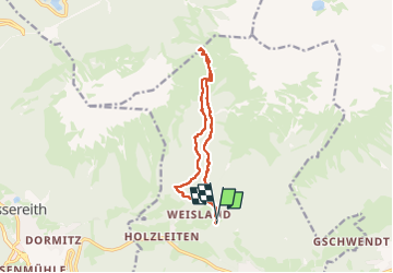
9,9 km | 17,8 km-effort 4h 23min Oui