![](/images/other/stat-length.png)
![Randonnée Marche Herve - 20240606 - IPA Verviers- Reconnaissance balade - Photo](https://media.geolcdn.com/t/1900/400/4017dc65-60b3-416a-a1d4-c02f5ec63a20.jpg&format=pjpeg&maxdim=2)
20240606 - IPA Verviers- Reconnaissance balade
pierreh01
Utilisateur GUIDE
![Longueur](/images/other/stat-length.png)
![Altitude max](https://static1.geolcdn.com/siteimages/upload/files/1508320355ic_sort_altitude_max_24dp.png)
![Dénivelé positif](https://static1.geolcdn.com/siteimages/upload/files/1508320355ic_sort_den_pos_24dp.png)
![Km-Effort](/images/other/stat-length.png)
![Altitude min](https://static1.geolcdn.com/siteimages/upload/files/1508320355ic_sort_altitude_min_24dp.png)
![Dénivelé négatif](https://static1.geolcdn.com/siteimages/upload/files/1508320355ic_sort_den_neg_24dp.png)
![Boucle](https://static1.geolcdn.com/siteimages/upload/files/16400158638029165_repeat_loop_refresh_sync_direction_icon.png)
![Marche](https://static1.geolcdn.com/sitytour/trail-icons/101.png)
1h32
Difficulté : Moyen
![Scannez ce code QR pour ouvrir la randonnée dans l'application SityTrail](https://capi.geolives.com/qq0zvz2zws4bq2lad0pu/sitytour/trails/4081613/qr.png?size=200)
Application GPS de randonnée GRATUITE
À propos
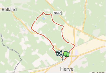
Randonnée Marche de 6,1 km à découvrir à Wallonie, Liège, Herve. Cette randonnée est proposée par pierreh01.
Description
Jeudi 6 juin 2024 : Reconnaissance de la balade annuelle de IPA Verviers.
C'est sous un très beau soleil et une température agréable que la reconnaissance de la balade No 17 de la Maison du Tourisme du Pays de Herve (MTPH), baptisée "De la Ligne 38 au Vieux Couvent. Entre Ville et bocages..." a été effectuée par mes soins.
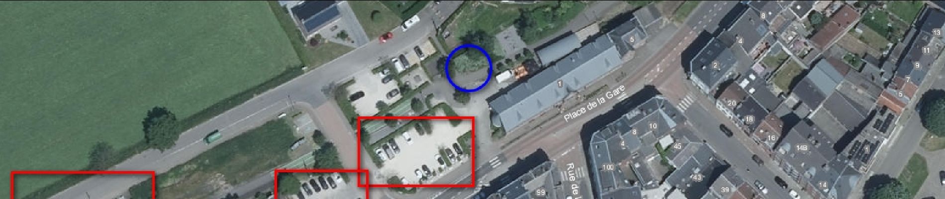
D/A : MTPH Place de la Gare, No 1 à 4650 HERVE, côté RAVel.
On emprunte le petit sentier nous amenant Rue du Calvaire où nous prenons à droite.
A hauteur de la croix, prendre à gauche le petit sentier herbeux, presque sec à ce jour, d'abord étroit et bordé par moments d'orties et de ronces, avant de s'élargir.
Au bout de ce sentier, à la croix, prendre à droite dans le hameau de Bellefontaine.
Au carrefour, prendre Bellefontaine à gauche en direction de Sarémont sur les hauteurs de BOLLAND. Attention, route avec de la circulation.
Prendre la première rue à droite, Sarémont, pendant quelques mètres avant de prendre la rue en cul de sac, vers la ferme de Havremont.
Poursuivre sa route dans le sentier et ensuite dans la première prairie fraîchement fauchée lors de notre passage.
Se diriger ensuite vers le gué du Bolland, normalement franchissable à pieds secs sur une dalle de béton. Ce jour, dalle recouverte d'eau courante et le Bolland est franchi avec un grand pas au départ d'une assise en béton.
Difficulté rencontrée, outre le franchissement du ruisseau, c'est la "grimpette" dans la prairie non fauchée en direction de Mur du Couvent.
Une fois sur cette route de crête, prendre à droite vers Herve jusqu'au carrefour avec Voie des Hougnes, où il faut prendre la première à gauche.
Passer devant le Recyparc, et prendre à droite sur Rue de Charneux jusqu'au RAVel où on s'engage à droite également.
Il ne reste que quelques centaines de mètres pour arriver au point de départ.
Distance annoncée de 5,6 Km, mesurée à 6,1 Km avec SityTrai.
Beaucoup de macadam quand même.
Localisation
Commentaires
Randonnées à proximité
![Randonnée Marche Herve - Entre bois et GR (8km) - Photo](https://media.geolcdn.com/t/375/260/ext.jpg?maxdim=2&url=https%3A%2F%2Fstatic1.geolcdn.com%2Fsiteimages%2Fupload%2Ffiles%2F1553511878bg_sport_marche.png)
![Marche Marche](https://static1.geolcdn.com/sitytour/trail-icons/101.png)
Marche
![](/images/other/stat-length.png)
![](https://static1.geolcdn.com/siteimages/upload/files/16400158638029165_repeat_loop_refresh_sync_direction_icon.png)
![Randonnée Marche Thimister-Clermont - La Minerie - Photo](https://media.geolcdn.com/t/375/260/ext.jpg?maxdim=2&url=https%3A%2F%2Fstatic1.geolcdn.com%2Fsiteimages%2Fupload%2Ffiles%2F1553511878bg_sport_marche.png)
![Marche Marche](https://static1.geolcdn.com/sitytour/trail-icons/101.png)
Marche
![](/images/other/stat-length.png)
![](https://static1.geolcdn.com/siteimages/upload/files/16400158638029165_repeat_loop_refresh_sync_direction_icon.png)
![Randonnée Marche Herve - Thimister et son Marché de Noël 🎅🎄 alsacien 🥨 - Photo](https://media.geolcdn.com/t/375/260/3e67f0de-4933-4699-a966-0b37dcd8155f.jpg&format=jpg&maxdim=2)
![Marche Marche](https://static1.geolcdn.com/sitytour/trail-icons/101.png)
Marche
![](/images/other/stat-length.png)
![](https://static1.geolcdn.com/siteimages/upload/files/16400158638029165_repeat_loop_refresh_sync_direction_icon.png)
![Randonnée Marche Blegny - 20230703 - Blegny-Mine 6.8 Km - Photo](https://media.geolcdn.com/t/375/260/840a4c96-62cb-4388-9c6c-d720f9bd1cc9.jpeg&format=jpg&maxdim=2)
![Marche Marche](https://static1.geolcdn.com/sitytour/trail-icons/101.png)
Marche
![](/images/other/stat-length.png)
![](https://static1.geolcdn.com/siteimages/upload/files/16400158638029165_repeat_loop_refresh_sync_direction_icon.png)
![Marche Marche](https://static1.geolcdn.com/sitytour/trail-icons/101.png)
Marche
![](/images/other/stat-length.png)
![](https://static1.geolcdn.com/siteimages/upload/files/16400158638029165_repeat_loop_refresh_sync_direction_icon.png)
![Marche Marche](https://static1.geolcdn.com/sitytour/trail-icons/101.png)
Marche
![](/images/other/stat-length.png)
![](https://static1.geolcdn.com/siteimages/upload/files/16400158638029165_repeat_loop_refresh_sync_direction_icon.png)
![Marche Marche](https://static1.geolcdn.com/sitytour/trail-icons/101.png)
Marche
![](/images/other/stat-length.png)
![](https://static1.geolcdn.com/siteimages/upload/files/16400158638029165_repeat_loop_refresh_sync_direction_icon.png)
![Randonnée Marche Soumagne - Cerexhe-Heuseux _1395 - Photo](https://media.geolcdn.com/t/375/260/a90bb153-f7f9-4ccc-abe3-d0c8ad0a64f0.jpg&format=jpg&maxdim=2)
![Marche Marche](https://static1.geolcdn.com/sitytour/trail-icons/101.png)
Marche
![](/images/other/stat-length.png)
![](https://static1.geolcdn.com/siteimages/upload/files/16400158638029165_repeat_loop_refresh_sync_direction_icon.png)
![Randonnée Marche Thimister-Clermont - La Minerie - Photo](https://media.geolcdn.com/t/375/260/2cdc1fed-57d0-4e96-9f7c-8bfb9eab2451.jpg&format=jpg&maxdim=2)
![Marche Marche](https://static1.geolcdn.com/sitytour/trail-icons/101.png)
Marche
![](/images/other/stat-length.png)
![](https://static1.geolcdn.com/siteimages/upload/files/16400158638029165_repeat_loop_refresh_sync_direction_icon.png)