Randonnée  Draveil - Chêne d’Antin soisy sur Seine Deaveil  - Photo

Chêne d’Antin soisy sur Seine Deaveil

© OpenStreetMap contributors
Longueur
Longueur
9,2 km
Altitude max
Altitude max
96 m
Dénivelé positif
Dénivelé positif
104 m
Km-Effort
Km-Effort  
10,6 km
Altitude min
Altitude min
29 m
Dénivelé négatif
Dénivelé négatif
102 m
Boucle
Boucle
Oui
Date de création :
2024-06-05 11:59:30.0
Dernière modification :
2024-06-06 07:02:42.854

(0 Avis)


Scannez ce code QR pour ouvrir la randonnée dans l'application SityTrail

Application GPS de randonnée GRATUITE

Logo SityTrail SityTrail

IGN / Instituts géographiques

Télécharger SityTrail sur l'App Store Télécharger SityTrail sur Google Play

Logo SityTrail SityTrail World

Le monde est à vous

Télécharger SityTrail sur l'App Store Télécharger SityTrail sur Google Play Télécharger SityTrail sur Huawei AppGallery

À propos

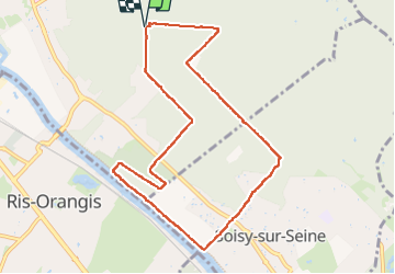
Randonnée de 9,2 km à découvrir à Île-de-France, Essonne, Draveil. Cette randonnée est proposée par 001185.1a411e07e05844e0b21535b8a6fe40df.0829.

Description

Marche

Profil altimétrique

Localisation

Pays :
France
Région :
Île-de-France
Département/Province :
Essonne
Commune :
Draveil
Localité :
Unknown
Départ:(Dec)
Départ:(UTM)
458008 ; 5391166 (31U) N.

Randonnées à proximité

Randonnée Marche Juvisy-sur-Orge - GRP CV-IDF 16R Juvisy-sur-Orge à Ballainvilliers - Photo
Marche
clalaur

Marche

Difficile
(1)
Juvisy-sur-Orge, Île-de-France, Essonne, France
14,8 km | 17 km-effort
3h 52min
Non
Randonnée Marche Montgeron - J 38 Montgeron la Pelouse, forêt de Sénart - Photo
Marche

Marche

Moyen
(3)
Montgeron, Île-de-France, Essonne, France
12,3 km | 13,2 km-effort
3h 9min
Oui
Randonnée Marche Yerres - J 43  Yerres Parc Caillebotte, île des Prévôts - Photo
Marche

Marche

Moyen
(2)
Yerres, Île-de-France, Essonne, France
11,4 km | 13,1 km-effort
2h 59min
Oui
Randonnée Marche Montgeron - JC 28 Sénart, Champrosay, Soisy sur Seine - Photo
Marche

Marche

Difficile
(1)
Montgeron, Île-de-France, Essonne, France
21 km | 24 km-effort
5h 21min
Oui
Randonnée Marche Soisy-sur-Seine - Sénart arbres remarquables 1/2 - Photo
Marche
dmatignon

Marche

Facile
(1)
Soisy-sur-Seine, Île-de-France, Essonne, France
12,2 km | 13,1 km-effort
2h 55min
Oui
Randonnée Marche Draveil - Port aux Cerises - Ablon 21 km - Photo
Marche
GUIDE
jeanmarcMasson

Marche

Très difficile
(1)
Draveil, Île-de-France, Essonne, France
22 km | 25 km-effort
4h 51min
Oui
Randonnée Marche Yerres - Boucle Yerres - Réveillon- Bois de la Grange - 12 km - Photo
Marche
GUIDE
jeanmarcMasson

Marche

Difficile
(1)
Yerres, Île-de-France, Essonne, France
12,1 km | 14 km-effort
3h 11min
Oui
Randonnée Marche Yerres - SityTrail - Téléthon-2022-Circuit A - Photo
Marche
GUIDE
jeanmarcMasson

Marche

Moyen
(2)
Yerres, Île-de-France, Essonne, France
5,5 km | 6,1 km-effort
1h 23min
Oui
Randonnée Marche Yerres - Yerres - Montgeron - Brunoy 11,5 km - Photo
Marche
GUIDE
jeanmarcMasson

Marche

Difficile
(1)
Yerres, Île-de-France, Essonne, France
11,2 km | 12,4 km-effort
2h 49min
Oui


Fermer
Mes abonnements